Chest opened
+${chestReward.xp} XP
Explorer
NOUVEAU ×${chestReward.collectible.quantity}
tapez pour fermer
Chest locked

Open chests in the app

Around Us is built for your phone — chests unlock when you walk, explore and capture nearby places.

Enable Location

We need your location to show you interesting places around you

Discover nearby places

Find interesting locations and hidden gems around you

Precise directions

Get accurate directions and distances to places

Your location is never shared with other users. It's only used when you tap the location button.

Lake Moultrie

Log in to your account

Start exploring — it's free

Trusted by 72,878 travelers worldwide

Continue with Google
Continue with Apple
or

We will send you a code to connect

By continuing, you accept our Terms and Conditions and our Privacy Policy

Check your inbox

We've sent a pincode in your inbox. Please enter the code below.

Lake Moultrie
Discussion Reviews 1 Photos
16.8k Popularity

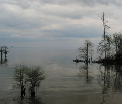
Lake Moultrie, man-made reservoir in South Carolina, United States

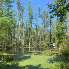
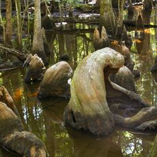
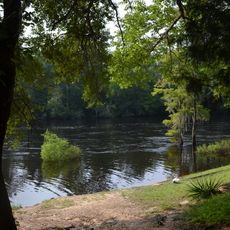
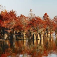
Lake Moultrie is a large body of water in Bonneau that forms part of the Santee-Cooper reservoir system. The lake is bounded by dams and dikes that create a broad, flat basin, and it contains numerous channels, backwater sloughs, and coves lined with cypress and tupelo trees.

The lake was created in the 1930s during the Great Depression as part of a water control and electricity generation project. The area was cleared of trees before the water was dammed to prevent flooding in surrounding farmland and swamps.

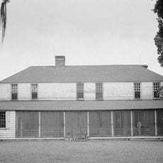
The lake is named after William Moultrie, an 18th-century American military officer. Today, locals use this water for fishing and boating, showing how the place has become woven into the rhythm of daily life in the region.

The best time to explore is on a cool day, especially early morning when the sun is not too strong. Several boat ramps like the Amos Lee Gourdine Boat Ramp serve as good starting points to navigate the waterways and shallow areas.

In the 1940s, a population of striped bass became trapped in the lake and thrived in freshwater, proving that these ocean fish could survive and breed entirely in lakes. This discovery made the water a significant site for fish research and sport fishing in the region.

The community of curious travelers

AroundUs brings together thousands of curated places, local tips, and hidden gems, enriched daily by 60,000 contributors worldwide.

Start exploring
Location
GPS coordinates
33.31307,-80.07226
Latest update
February 17, 2026 01:40
Around this place
Mepkin Abbey
United States of America

Mepkin Abbey

24.7 km
Lewisfield Plantation
United States of America

Lewisfield Plantation

18.5 km
Cypress Gardens
United States of America

Cypress Gardens

31.7 km
Medway
United States of America

Medway

32.8 km
Colonial Dorchester State Historic Site
United States of America

Colonial Dorchester State Historic Site

41.5 km
Francis Beidler Forest
United States of America

Francis Beidler Forest

28.3 km
Mulberry Plantation
United States of America

Mulberry Plantation

19.7 km
Middleburg Plantation
United States of America

Middleburg Plantation

33.5 km
Givhans Ferry State Park
United States of America

Givhans Ferry State Park

42.3 km
Hell Hole Swamp
United States of America

Hell Hole Swamp

35.6 km
Santee National Wildlife Refuge
United States of America

Santee National Wildlife Refuge

32.6 km
Cypress Gardens
United States of America

Cypress Gardens

31 km
Biggin Church
United States of America

Biggin Church

14.9 km
Old White Meeting House Ruins and Cemetery
United States of America

Old White Meeting House Ruins and Cemetery

40.3 km
Santee Indian Mound and Fort Watson
United States of America

Santee Indian Mound and Fort Watson

42.3 km
Gippy Plantation
United States of America

Gippy Plantation

16.9 km
Davis House
United States of America

Davis House

40.4 km
Summerton High School
United States of America

Summerton High School

41.2 km
Lawson's Pond Plantation
United States of America

Lawson's Pond Plantation

15.4 km
Saint Paul Campground
United States of America

Saint Paul Campground

40 km
Cypress Methodist Camp Ground
United States of America

Cypress Methodist Camp Ground

25 km
Numertia Plantation
United States of America

Numertia Plantation

20.8 km
Pineville Historic District
United States of America

Pineville Historic District

9.8 km
White Church
United States of America

White Church

44.1 km
William Robertson House
United States of America

William Robertson House

9.7 km
Taveau Church
United States of America

Taveau Church

26.1 km
Manning Commercial Historic District
United States of America

Manning Commercial Historic District

44.4 km
St. Paul's Church
United States of America

St. Paul's Church

35 km
Show the full map
Reviews
Share your experience

No review yet

Discussions
Start a discussion...

No discussion yet

« Lake Moultrie - man-made reservoir in South Carolina, United States » is provided by Around Us (aroundus.com). Images and texts are derived from Wikimedia project under a Creative Commons license. You are allowed to copy, distribute, and modify copies of this page, under the conditions set by the license, as long as this note is clearly visible.

Discover hidden gems everywhere you go!

From secret cafés to breathtaking viewpoints, skip the crowded tourist spots and find places that match your style. Our app makes it easy with voice search, smart filtering, route optimization, and insider tips from travelers worldwide. Download now for the complete mobile experience.

Around Us App Screenshot

A unique approach to discovering new places

Le Figaro

All the places worth exploring

France Info

A tailor-made excursion in just a few clicks

20 Minutes

Around Us
Travel Guide & Maps
Download

Send to your phone

QR Code
1

Open the camera app on your mobile.

2

Point at the QR code with your camera. A notification will appear.

3

Tap the notification to open the link.