Enable Location

We need your location to show you interesting places around you

Discover nearby places

Find interesting locations and hidden gems around you

Precise directions

Get accurate directions and distances to places

Your location is never shared with other users. It's only used when you tap the location button.

Lower Blackburn Grade Bridge

Log in to your account

Start exploring — it's free

Trusted by 62,961 travelers worldwide

Continue with Google
Continue with Apple
or

We will send you a code to connect

By continuing, you accept our Terms and Conditions and our Privacy Policy

Check your inbox

We've sent a pincode in your inbox. Please enter the code below.

Discussion Reviews 1 Photos
1.3k Popularity

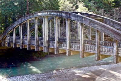
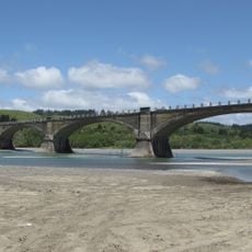
Lower Blackburn Grade Bridge, Historic bridge near Bridgeville, California.

The Lower Blackburn Grade Bridge is a reinforced concrete arch span crossing the Van Duzen River with distinctive inset panels decorating its surface. The structure showcases the through-arch design that defined engineering practices during the early 20th century.

John B. Leonard designed this bridge in 1925 as one of five structures built for California State Route 36 connecting Fortuna and Red Bluff. It emerged during a period when engineers were experimenting with new reinforced concrete techniques for river crossings.

The National Register of Historic Places listed this bridge in 1981, marking its importance in California's transportation development and engineering advancement.

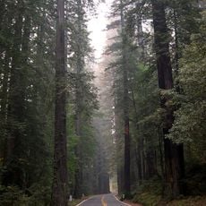
The bridge sits in a rural area west of Bridgeville requiring travel through secondary roads in Humboldt County. Visitors should check road conditions before driving and allow time to locate it off the main highway routes.

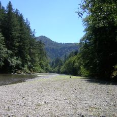
The structure appeared in the 1995 film Outbreak when a helicopter flew directly beneath it during a chase scene over the Van Duzen River. This film moment added an unexpected connection to cinema history for a quiet engineering landmark.

The community of curious travelers

AroundUs brings together thousands of curated places, local tips, and hidden gems, enriched daily by 60,000 contributors worldwide.

Start exploring
Location
Architects
John B. Leonard
GPS coordinates
40.48056,-123.88944
Latest update
December 14, 2025 18:13
Around this place
Humboldt Redwoods State Park
United States of America

Humboldt Redwoods State Park

20 km
Fort Humboldt State Historic Park
United States of America

Fort Humboldt State Historic Park

41.6 km
King Range
United States of America

King Range

40.8 km
Sequoia Park Zoo
United States of America

Sequoia Park Zoo

39.4 km
Headwaters Forest Reserve
United States of America

Headwaters Forest Reserve

25.2 km
Grizzly Creek Redwoods State Park
United States of America

Grizzly Creek Redwoods State Park

1.5 km
Humboldt Bay National Wildlife Refuge
United States of America

Humboldt Bay National Wildlife Refuge

35.9 km
Fernbridge
United States of America

Fernbridge

30.4 km
Gingerbread Mansion
United States of America

Gingerbread Mansion

33.3 km
King Range Wilderness
United States of America

King Range Wilderness

40.8 km
Table Bluff Light
United States of America

Table Bluff Light

40.4 km
Shaw House
United States of America

Shaw House

33.3 km
Centerville Beach Cross
United States of America

Centerville Beach Cross

40.3 km
A. Berding House
United States of America

A. Berding House

33.3 km
Ferndale Library
United States of America

Ferndale Library

33.3 km
William S. Clark House
United States of America

William S. Clark House

42.1 km
Humboldt Botanical Gardens
United States of America

Humboldt Botanical Gardens

35.6 km
Carnegie Free Library
United States of America

Carnegie Free Library

42.5 km
Ferndale Museum
United States of America

Ferndale Museum

33.5 km
Scotia Bluffs
United States of America

Scotia Bluffs

18 km
Eureka Municipal Auditorium
United States of America

Eureka Municipal Auditorium

42.2 km
Rectory, Catholic Church of the Assumption
United States of America

Rectory, Catholic Church of the Assumption

33.2 km
Winema Theater
United States of America

Winema Theater

18.1 km
Grizzly Bluff School
United States of America

Grizzly Bluff School

25.5 km
Masonic Temple
United States of America

Masonic Temple

33.5 km
United States of America

Signal Peak

32.7 km
Alford-Nielson House
United States of America

Alford-Nielson House

33.3 km
Thomas F. Ricks House
United States of America

Thomas F. Ricks House

42.4 km
Show the full map
Reviews
Share your experience

No review yet

Discussions
Start a discussion...

No discussion yet

« Lower Blackburn Grade Bridge - Historic bridge near Bridgeville, California » is provided by Around Us (aroundus.com). Images and texts are derived from Wikimedia project under a Creative Commons license. You are allowed to copy, distribute, and modify copies of this page, under the conditions set by the license, as long as this note is clearly visible.

Discover hidden gems everywhere you go!

From secret cafés to breathtaking viewpoints, skip the crowded tourist spots and find places that match your style. Our app makes it easy with voice search, smart filtering, route optimization, and insider tips from travelers worldwide. Download now for the complete mobile experience.

Around Us App Screenshot

A unique approach to discovering new places

Le Figaro

All the places worth exploring

France Info

A tailor-made excursion in just a few clicks

20 Minutes

Around Us
Travel Guide & Maps
Download

Send to your phone

QR Code
1

Open the camera app on your mobile.

2

Point at the QR code with your camera. A notification will appear.

3

Tap the notification to open the link.