Enable Location

We need your location to show you interesting places around you

Discover nearby places

Find interesting locations and hidden gems around you

Precise directions

Get accurate directions and distances to places

Your location is never shared with other users. It's only used when you tap the location button.

Phantom Falls

Log in to your account

Start exploring — it's free

Trusted by 65,789 travelers worldwide

Continue with Google
Continue with Apple
or

We will send you a code to connect

By continuing, you accept our Terms and Conditions and our Privacy Policy

Check your inbox

We've sent a pincode in your inbox. Please enter the code below.

Phantom Falls
Discussion Reviews 1 Photos
6k Popularity

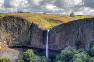
Phantom Falls, Seasonal waterfall at North Table Mountain Ecological Reserve in Oroville, California.

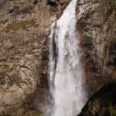
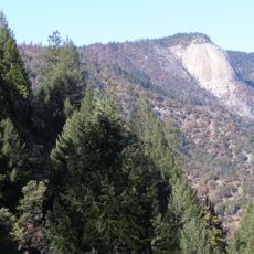
Phantom Falls is a seasonal waterfall in the North Table Mountain Ecological Reserve near Oroville, California, where water pours over the basalt edge of Coal Canyon and drops about 160 feet (roughly 50 meters) into a pool below. At the base, a natural grotto cuts into the rock, making it possible to stand behind the curtain of water when the flow is strong enough.

During the California Gold Rush, miners dug a shaft directly behind the falls in search of deposits, leaving traces that are still visible in the rock today. The gold prospects turned out to be minimal, and the site was quickly abandoned.

The name Phantom comes from the way the falls appear and vanish with the rains, which locals find fitting for a place that only exists part of the year. Hikers who visit during the short window when water flows often describe the experience as catching something rare before it disappears again.

A CDFW Lands Pass is required to enter the reserve and should be arranged before arriving, since there is no on-site purchase option. The trail from the Cherokee Road trailhead covers rocky terrain, and the ground becomes very slippery after rain, so visiting during dry weather makes for a safer hike.

The natural grotto carved into the rock at the base of the falls is large enough to walk into, letting visitors stand behind the falling water and look out through it. This is only possible when the flow is strong, which ties the experience directly to the seasonal rains.

The community of curious travelers

AroundUs brings together thousands of curated places, local tips, and hidden gems, enriched daily by 60,000 contributors worldwide.

Start exploring
GPS coordinates
39.61050,-121.56073
Latest update
March 3, 2026 10:09
Around this place
Lake Oroville
United States of America

Lake Oroville

10.4 km
Bidwell Park
United States of America

Bidwell Park

25.8 km
Bidwell Mansion State Historic Park
United States of America

Bidwell Mansion State Historic Park

28.6 km
Feather Falls
United States of America

Feather Falls

24.8 km
Bidwell Bar Bridge
United States of America

Bidwell Bar Bridge

13.1 km
North Table Mountain Ecological Reserve
United States of America

North Table Mountain Ecological Reserve

3 km
Lake Oroville State Recreation Area
United States of America

Lake Oroville State Recreation Area

10.4 km
Oroville Chinese Temple
United States of America

Oroville Chinese Temple

10.8 km
Sacramento River National Wildlife Refuge
United States of America

Sacramento River National Wildlife Refuge

35.4 km
Bald Rock Dome
United States of America

Bald Rock Dome

22 km
Poe Dam
United States of America

Poe Dam

24.7 km
Chico Air Museum
United States of America

Chico Air Museum

33.3 km
Pulga Bridges
United States of America

Pulga Bridges

22.5 km
Old Bidwell Bar Bridge
United States of America

Old Bidwell Bar Bridge

12.2 km
Gianella Bridge
United States of America

Gianella Bridge

40.5 km
Chico Community Observatory
United States of America

Chico Community Observatory

26.1 km
Live Oak Historic Commercial District
United States of America

Live Oak Historic Commercial District

38.3 km
A. H. Chapman House
United States of America

A. H. Chapman House

26.4 km
Silberstein Park Building
United States of America

Silberstein Park Building

27.2 km
Collins Lake Beach
United States of America

Collins Lake Beach

37 km
Bowlero
United States of America

Bowlero

30.3 km
Museum of Northern California Art
United States of America

Museum of Northern California Art

28.1 km
Oroville Carnegie Library
United States of America

Oroville Carnegie Library

10.9 km
Arboreto de la Universidad de California Campus de Chico
United States of America

Arboreto de la Universidad de California Campus de Chico

28.2 km
Oroville Chinese Temple
United States of America

Oroville Chinese Temple

10.8 km
Senator Theatre
United States of America

Senator Theatre

27.1 km
Oroville State Theatre
United States of America

Oroville State Theatre

10.9 km
Beatson Falls
United States of America

Beatson Falls

2.8 km
Show the full map
Reviews
Share your experience

No review yet

Discussions
Start a discussion...

No discussion yet

« Phantom Falls - Seasonal waterfall at North Table Mountain Ecological Reserve in Oroville, California » is provided by Around Us (aroundus.com). Images and texts are derived from Wikimedia project under a Creative Commons license. You are allowed to copy, distribute, and modify copies of this page, under the conditions set by the license, as long as this note is clearly visible.

Discover hidden gems everywhere you go!

From secret cafés to breathtaking viewpoints, skip the crowded tourist spots and find places that match your style. Our app makes it easy with voice search, smart filtering, route optimization, and insider tips from travelers worldwide. Download now for the complete mobile experience.

Around Us App Screenshot

A unique approach to discovering new places

Le Figaro

All the places worth exploring

France Info

A tailor-made excursion in just a few clicks

20 Minutes

Around Us
Travel Guide & Maps
Download

Send to your phone

QR Code
1

Open the camera app on your mobile.

2

Point at the QR code with your camera. A notification will appear.

3

Tap the notification to open the link.