Lake Oroville

Log in to your account

AroundUs is a community-driven map of interesting places, built by curious explorers like you. It grows with every review, story, and photo you share.
Connect to save your favorite spots, contribute locations, and create personalized routes.
Continue with Google
Continue with Apple
Continue with X
Continue with Facebook
Continue with email
By continuing, you accept our Terms and Conditions and our Privacy Policy
Create an account
Add to collection
Map
Suggest a change
Share

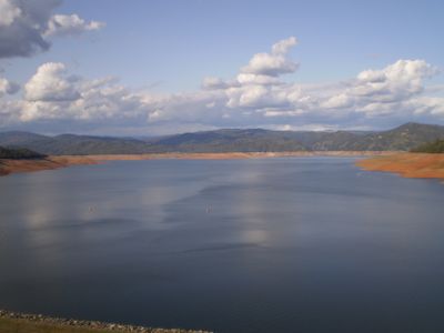
Lake Oroville, Reservoir in Oroville, California, US

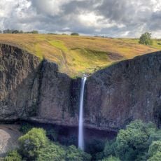
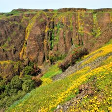
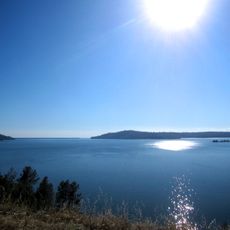
Lake Oroville is a reservoir in Northern California formed by a dam on the Feather River, with shorelines stretching over 170 miles (about 270 kilometers) through rolling foothills and steep canyon walls. The water fills a valley that cuts deep into the Sierra Nevada foothills, creating narrow arms and coves that branch into surrounding drainages.

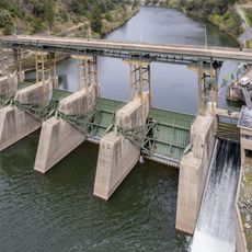
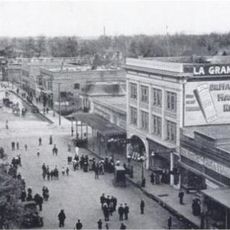
The dam that created the reservoir was built during the 1960s as part of California's effort to store water for irrigation and municipal use in drier regions. Construction required flooding the original valley and relocating communities that had existed along the Feather River for generations.

The Feather River Nature Center at Lake Oroville presents educational exhibits about local wildlife, plant species, and regional environmental patterns.

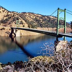
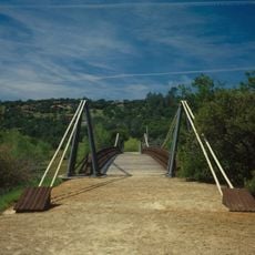
Several boat ramps provide access for watercraft, while hiking trails begin at different points along the shore and lead up into the surrounding hills. Most facilities stay open year-round, though water levels can drop significantly during summer months compared to spring when snowmelt fills the reservoir.

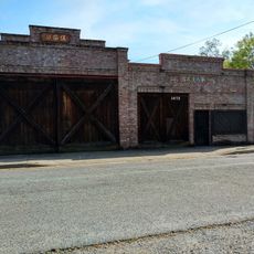
When water levels drop during dry years, remnants of old bridges and building foundations from flooded settlements become visible along the exposed lakebed. Some years reveal sections of former roads that once connected communities in the valley before the dam was built.

Location: Oroville

Elevation above the sea: 275 m

GPS coordinates: 39.56360,-121.45600

Latest update: December 14, 2025 17:31

Photos
Around this place
Bidwell Park
United States of America

Bidwell Park

36 km
New Bullards Bar Reservoir
United States of America

New Bullards Bar Reservoir

33.1 km
New Bullards Bar Dam
United States of America

New Bullards Bar Dam

32.9 km
South Yuba River State Park
United States of America

South Yuba River State Park

37.6 km
Bridgeport Covered Bridge
United States of America

Bridgeport Covered Bridge

37.6 km
Feather Falls
United States of America

Feather Falls

17.9 km
Phantom Falls
United States of America

Phantom Falls

10.4 km
Bidwell Bar Bridge
United States of America

Bidwell Bar Bridge

2.7 km
North Table Mountain Ecological Reserve
United States of America

North Table Mountain Ecological Reserve

11.4 km
Lake Oroville State Recreation Area
United States of America

Lake Oroville State Recreation Area

0 m
Oroville Chinese Temple
United States of America

Oroville Chinese Temple

10.6 km
Bald Rock Dome
United States of America

Bald Rock Dome

16 km
Poe Dam
United States of America

Poe Dam

27.4 km
Oregon Creek Covered Bridge
United States of America

Oregon Creek Covered Bridge

37.1 km
Pulga Bridges
United States of America

Pulga Bridges

25.7 km
Old Bidwell Bar Bridge
United States of America

Old Bidwell Bar Bridge

2.9 km
Chico Community Observatory
United States of America

Chico Community Observatory

36.3 km
Live Oak Historic Commercial District
United States of America

Live Oak Historic Commercial District

36.6 km
A. H. Chapman House
United States of America

A. H. Chapman House

36.8 km
Silberstein Park Building
United States of America

Silberstein Park Building

37.6 km
Collins Lake Beach
United States of America

Collins Lake Beach

28 km
Museum of Northern California Art
United States of America

Museum of Northern California Art

38.5 km
Oroville Carnegie Library
United States of America

Oroville Carnegie Library

10.5 km
Oroville Chinese Temple
United States of America

Oroville Chinese Temple

10.7 km
Oroville State Theatre
United States of America

Oroville State Theatre

10.2 km
Senator Theatre
United States of America

Senator Theatre

37.5 km
Beatson Falls
United States of America

Beatson Falls

11.1 km
Castleberry Covered Bridge
United States of America

Castleberry Covered Bridge

7.2 km
Show the full map
Reviews

Real people, real opinions — but not verified.

Visited this place? Tap the stars to rate it and share your experience / photos with the community! Try now! You can cancel it anytime.

sochabrison
@sochabrison

Oct 18, 2025 07:19

Grand enjoyment. Make memories. Family friendly.

« Lake Oroville - Reservoir in Oroville, California, US » is provided by Around Us (aroundus.com). Images and texts are derived from Wikimedia project under a Creative Commons license. You are allowed to copy, distribute, and modify copies of this page, under the conditions set by the license, as long as this note is clearly visible.

Discover hidden gems everywhere you go!

From secret cafés to breathtaking viewpoints, skip the crowded tourist spots and find places that match your style. Our app makes it easy with voice search, smart filtering, route optimization, and insider tips from travelers worldwide. Download now for the complete mobile experience.

Around Us App Screenshot

A unique approach to discovering new places

Le Figaro

All the places worth exploring

France Info

A tailor-made excursion in just a few clicks

20 Minutes