Enable Location

We need your location to show you interesting places around you

Discover nearby places

Find interesting locations and hidden gems around you

Precise directions

Get accurate directions and distances to places

Your location is never shared with other users. It's only used when you tap the location button.

Bidwell Bar Bridge

Log in to your account

Start exploring — it's free

Trusted by 61,399 travelers worldwide

Continue with Google
Continue with Apple
or

We will send you a code to connect

By continuing, you accept our Terms and Conditions and our Privacy Policy

Check your inbox

We've sent a pincode in your inbox. Please enter the code below.

Bidwell Bar Bridge

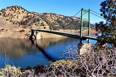
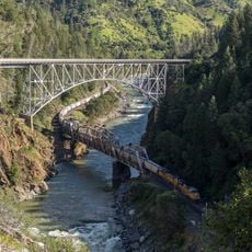
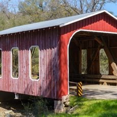
Bidwell Bar Bridge, Suspension bridge in Oroville, United States

Description

Bidwell Bar Bridge is a steel cable suspension bridge that spans across Lake Oroville and connects two sections of State Route 162. The structure uses cable towers to maintain its span across the water, creating a distinctive curved profile when viewed from different angles.

History

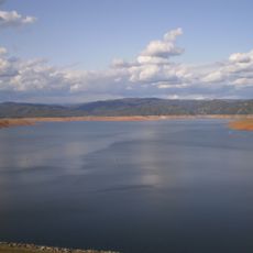
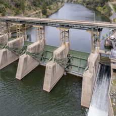
The original bridge was built in 1855 and had to be relocated when the Oroville Dam construction began in the 1960s. The new structure was completed to maintain road access across the newly formed Lake Oroville.

Culture

The bridge represents a key point in the landscape for people traveling through the area, marking a transition between different parts of the region. It stands as a reminder of how engineering shaped local communities during the mid-20th century.

Practical

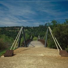
The bridge remains open as an active road crossing, and visitors can drive across to experience the views of the lake and surrounding terrain. For the best perspective, stop at nearby pullouts or viewpoints along the approach roads rather than trying to view it while driving.

Did you know?

The name Bidwell Bar comes from John Bidwell, an early settler and gold prospector whose name marks several locations in the area. This connection to the Gold Rush era adds a layer of pioneer history to what might otherwise seem like just a modern road crossing.

Location
Official opening
1967
Length
338 m
GPS coordinates
39.55021,-121.43002
Latest update
December 10, 2025 16:29

AroundUs brings together thousands of curated places, local tips, and hidden gems, enriched daily by 60,000 contributors worldwide. Discover all places nearby (Oroville).

Around this place
Lake Oroville
United States of America

Lake Oroville

2.7 km
Bidwell Park
United States of America

Bidwell Park

38.6 km
New Bullards Bar Reservoir
United States of America

New Bullards Bar Reservoir

30.4 km
Bidwell Mansion State Historic Park
United States of America

Bidwell Mansion State Historic Park

41.7 km
New Bullards Bar Dam
United States of America

New Bullards Bar Dam

30.2 km
South Yuba River State Park
United States of America

South Yuba River State Park

35.1 km
Bridgeport Covered Bridge
United States of America

Bridgeport Covered Bridge

35.1 km
Feather Falls
United States of America

Feather Falls

16.9 km
Phantom Falls
United States of America

Phantom Falls

13.1 km
North Table Mountain Ecological Reserve
United States of America

North Table Mountain Ecological Reserve

14 km
Englebright Lake
United States of America

Englebright Lake

37.1 km
Lake Oroville State Recreation Area
United States of America

Lake Oroville State Recreation Area

2.7 km
Oroville Chinese Temple
United States of America

Oroville Chinese Temple

11.9 km
Bald Rock Dome
United States of America

Bald Rock Dome

15.5 km
Poe Dam
United States of America

Poe Dam

28.9 km
Englebright Dam
United States of America

Englebright Dam

37.2 km
Oregon Creek Covered Bridge
United States of America

Oregon Creek Covered Bridge

34.4 km
Pulga Bridges
United States of America

Pulga Bridges

27.3 km
Old Bidwell Bar Bridge
United States of America

Old Bidwell Bar Bridge

2.5 km
Chico Community Observatory
United States of America

Chico Community Observatory

39 km
Live Oak Historic Commercial District
United States of America

Live Oak Historic Commercial District

36.5 km
A. H. Chapman House
United States of America

A. H. Chapman House

39.4 km
Silberstein Park Building
United States of America

Silberstein Park Building

40.3 km
Oroville Carnegie Library
United States of America

Oroville Carnegie Library

11.8 km
Oroville Chinese Temple
United States of America

Oroville Chinese Temple

12 km
Oroville State Theatre
United States of America

Oroville State Theatre

11.5 km
Senator Theatre
United States of America

Senator Theatre

40.2 km
Castleberry Covered Bridge
United States of America

Castleberry Covered Bridge

9.8 km
Show the full map
« Bidwell Bar Bridge - Suspension bridge in Oroville, United States » is provided by Around Us (aroundus.com). Images and texts are derived from Wikimedia project under a Creative Commons license. You are allowed to copy, distribute, and modify copies of this page, under the conditions set by the license, as long as this note is clearly visible.

Discover hidden gems everywhere you go!

From secret cafés to breathtaking viewpoints, skip the crowded tourist spots and find places that match your style. Our app makes it easy with voice search, smart filtering, route optimization, and insider tips from travelers worldwide. Download now for the complete mobile experience.

Around Us App Screenshot

A unique approach to discovering new places

Le Figaro

All the places worth exploring

France Info

A tailor-made excursion in just a few clicks

20 Minutes

Around Us
Travel Guide & Maps
Download

Send to your phone

QR Code
1

Open the camera app on your mobile.

2

Point at the QR code with your camera. A notification will appear.

3

Tap the notification to open the link.