Enable Location

We need your location to show you interesting places around you

Discover nearby places

Find interesting locations and hidden gems around you

Precise directions

Get accurate directions and distances to places

Your location is never shared with other users. It's only used when you tap the location button.

North Table Mountain Ecological Reserve

Log in to your account

Start exploring — it's free

Trusted by 64,607 travelers worldwide

Continue with Google
Continue with Apple
or

We will send you a code to connect

By continuing, you accept our Terms and Conditions and our Privacy Policy

Check your inbox

We've sent a pincode in your inbox. Please enter the code below.

North Table Mountain Ecological Reserve
Discussion Reviews 1 Photos
5.1k Popularity

North Table Mountain Ecological Reserve, Protected nature area in Oroville, California.

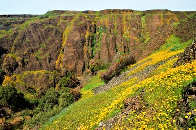
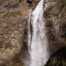
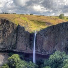
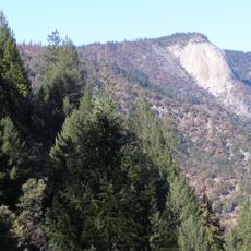
North Table Mountain Ecological Reserve is a protected area near Oroville in northern California, set on a raised basalt plateau shaped by volcanic rock formations, open grasslands, and seasonal waterfalls. After winter rains, shallow rock basins fill with water and form temporary pools that dry up again by spring.

California acquired this land in 1993 to protect a rare system of seasonal rock pools that exists at this scale in very few other places. The funds came from a state conservation program focused on saving habitats at risk.

Visitors walking through the reserve in spring can spot rare plants that grow only in the Oroville area, including Butte County meadowfoam, a flowering plant found nowhere else on Earth. The rock pools that fill with rainwater are the only habitats where these species can survive.

A valid day or annual pass is required to enter, except for those who hold a valid hunting or fishing license. The best time to visit is from January to April, when the seasonal waterfalls are running and the rock pools have filled with water.

The reserve holds one of only 4 known sites in California where Northern Basalt Flow Vernal Pools occur, a type of seasonal rock pool that can only form on certain volcanic surfaces. The combination of basalt rock and the local climate creates the precise conditions these pools need, and those conditions rarely come together elsewhere.

The community of curious travelers

AroundUs brings together thousands of curated places, local tips, and hidden gems, enriched daily by 60,000 contributors worldwide.

Start exploring
Location
GPS coordinates
39.63610,-121.55000
Latest update
March 3, 2026 08:15
Around this place
Lake Oroville
United States of America

Lake Oroville

11.4 km
Bidwell Park
United States of America

Bidwell Park

24.6 km
Bidwell Mansion State Historic Park
United States of America

Bidwell Mansion State Historic Park

28.1 km
Feather Falls
United States of America

Feather Falls

23.6 km
Phantom Falls
United States of America

Phantom Falls

3 km
Bidwell Bar Bridge
United States of America

Bidwell Bar Bridge

14 km
Lake Oroville State Recreation Area
United States of America

Lake Oroville State Recreation Area

11.4 km
Oroville Chinese Temple
United States of America

Oroville Chinese Temple

13.7 km
Sacramento River National Wildlife Refuge
United States of America

Sacramento River National Wildlife Refuge

35.5 km
Bald Rock Dome
United States of America

Bald Rock Dome

20.6 km
United States of America

Bucks Lake

43.2 km
Poe Dam
United States of America

Poe Dam

21.7 km
Chico Air Museum
United States of America

Chico Air Museum

32.3 km
Pulga Bridges
United States of America

Pulga Bridges

19.5 km
Old Bidwell Bar Bridge
United States of America

Old Bidwell Bar Bridge

13.7 km
Gianella Bridge
United States of America

Gianella Bridge

40.3 km
Chico Community Observatory
United States of America

Chico Community Observatory

25 km
Live Oak Historic Commercial District
United States of America

Live Oak Historic Commercial District

41.3 km
Tobin Bridges
United States of America

Tobin Bridges

39 km
A. H. Chapman House
United States of America

A. H. Chapman House

26 km
Silberstein Park Building
United States of America

Silberstein Park Building

26.8 km
Museum of Northern California Art
United States of America

Museum of Northern California Art

27.6 km
Oroville Carnegie Library
United States of America

Oroville Carnegie Library

13.8 km
Arboreto de la Universidad de California Campus de Chico
United States of America

Arboreto de la Universidad de California Campus de Chico

27.8 km
Oroville Chinese Temple
United States of America

Oroville Chinese Temple

13.7 km
Senator Theatre
United States of America

Senator Theatre

26.7 km
Oroville State Theatre
United States of America

Oroville State Theatre

13.8 km
Castleberry Covered Bridge
United States of America

Castleberry Covered Bridge

5 km
Show the full map
Reviews
Share your experience

No review yet

Discussions
Start a discussion...

No discussion yet

« North Table Mountain Ecological Reserve - Protected nature area in Oroville, California » is provided by Around Us (aroundus.com). Images and texts are derived from Wikimedia project under a Creative Commons license. You are allowed to copy, distribute, and modify copies of this page, under the conditions set by the license, as long as this note is clearly visible.

Discover hidden gems everywhere you go!

From secret cafés to breathtaking viewpoints, skip the crowded tourist spots and find places that match your style. Our app makes it easy with voice search, smart filtering, route optimization, and insider tips from travelers worldwide. Download now for the complete mobile experience.

Around Us App Screenshot

A unique approach to discovering new places

Le Figaro

All the places worth exploring

France Info

A tailor-made excursion in just a few clicks

20 Minutes

Around Us
Travel Guide & Maps
Download

Send to your phone

QR Code
1

Open the camera app on your mobile.

2

Point at the QR code with your camera. A notification will appear.

3

Tap the notification to open the link.