Enable Location

We need your location to show you interesting places around you

Discover nearby places

Find interesting locations and hidden gems around you

Precise directions

Get accurate directions and distances to places

Your location is never shared with other users. It's only used when you tap the location button.

Tobin Bridges

Log in to your account

Start exploring — it's free

Trusted by 62,372 travelers worldwide

Continue with Google
Continue with Apple
or

We will send you a code to connect

By continuing, you accept our Terms and Conditions and our Privacy Policy

Check your inbox

We've sent a pincode in your inbox. Please enter the code below.

Tobin Bridges

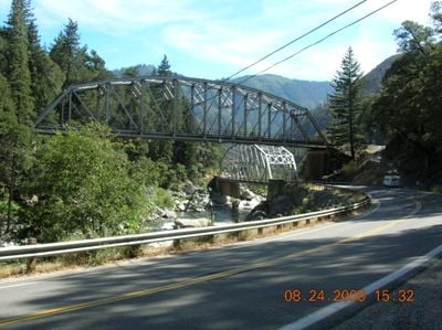
Tobin Bridges, transportation infrastructure in California

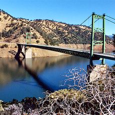
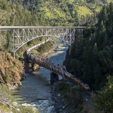
The Tobin Bridges are two crossing structures that span the North Fork of the Feather River in California. The railway bridge was built in 1910 with a camelback Pratt truss design measuring about 234 feet (71 meters), while the 1936 road bridge has a single span of approximately 290 feet (88 meters) designed to carry vehicles across the same river.

The railway bridge was built in 1910 by the Western Pacific Railroad as part of a transcontinental route through the Sierra Nevada, maintaining a gentle 1 percent grade to ease train passage. The road bridge followed in 1936 as State Route 70 was developed through the Feather River Gorge.

The Tobin Bridges represent how remote mountain areas were connected to the wider world through rail and road infrastructure. Both structures remain visible reminders of how communities relied on these crossings to enable commerce and movement through challenging terrain.

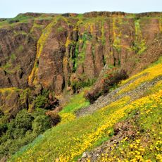
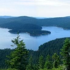
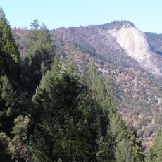
The bridges sit in a tight canyon with steep rock walls and dense forest cover, so the setting is defined by the river and rugged topography. Visitors should know that the road bridge has narrow travel lanes without shoulders and handles about a thousand vehicles daily.

The railway bridge is part of a transcontinental route with the gentlest grade of any mountain crossing from its era and is recognized as one of the 7 Wonders of the Railroad World in Plumas County. This special engineering feat allowed trains to traverse the mountains more efficiently.

The community of curious travelers

AroundUs brings together thousands of curated places, local tips, and hidden gems, enriched daily by 60,000 contributors worldwide.

Start exploring
Location
GPS coordinates
39.93660,-121.31600
Latest update
February 9, 2026 07:40
Around this place
Lake Oroville
United States of America

Lake Oroville

43.2 km
Lake Almanor
United States of America

Lake Almanor

37.6 km
Bidwell Park
United States of America

Bidwell Park

43.7 km
Bidwell Mansion State Historic Park
United States of America

Bidwell Mansion State Historic Park

50.3 km
Ishi Wilderness
United States of America

Ishi Wilderness

43.4 km
Feather Falls
United States of America

Feather Falls

32.9 km
Phantom Falls
United States of America

Phantom Falls

41.9 km
Bidwell Bar Bridge
United States of America

Bidwell Bar Bridge

44.1 km
North Table Mountain Ecological Reserve
United States of America

North Table Mountain Ecological Reserve

39 km
Bucks Lake Wilderness
United States of America

Bucks Lake Wilderness

12.1 km
Lake Oroville State Recreation Area
United States of America

Lake Oroville State Recreation Area

43.2 km
Oroville Chinese Temple
United States of America

Oroville Chinese Temple

51.5 km
Little Grass Valley Reservoir
United States of America

Little Grass Valley Reservoir

36.2 km
Bald Rock Dome
United States of America

Bald Rock Dome

31.4 km
United States of America

Bucks Lake

14.4 km
Poe Dam
United States of America

Poe Dam

17.3 km
Chico Air Museum
United States of America

Chico Air Museum

48.6 km
Pulga Bridges
United States of America

Pulga Bridges

19.6 km
Old Bidwell Bar Bridge
United States of America

Old Bidwell Bar Bridge

46 km
Chico Community Observatory
United States of America

Chico Community Observatory

44 km
Butte Creek Ecological Reserve
United States of America

Butte Creek Ecological Reserve

18.9 km
A. H. Chapman House
United States of America

A. H. Chapman House

49.8 km
Silberstein Park Building
United States of America

Silberstein Park Building

50.4 km
Museum of Northern California Art
United States of America

Museum of Northern California Art

50.3 km
Arboreto de la Universidad de California Campus de Chico
United States of America

Arboreto de la Universidad de California Campus de Chico

51 km
Senator Theatre
United States of America

Senator Theatre

50.3 km
Oroville State Theatre
United States of America

Oroville State Theatre

51.4 km
Castleberry Covered Bridge
United States of America

Castleberry Covered Bridge

42.3 km
Show the full map
« Tobin Bridges - transportation infrastructure in California » is provided by Around Us (aroundus.com). Images and texts are derived from Wikimedia project under a Creative Commons license. You are allowed to copy, distribute, and modify copies of this page, under the conditions set by the license, as long as this note is clearly visible.

Discover hidden gems everywhere you go!

From secret cafés to breathtaking viewpoints, skip the crowded tourist spots and find places that match your style. Our app makes it easy with voice search, smart filtering, route optimization, and insider tips from travelers worldwide. Download now for the complete mobile experience.

Around Us App Screenshot

A unique approach to discovering new places

Le Figaro

All the places worth exploring

France Info

A tailor-made excursion in just a few clicks

20 Minutes

Around Us
Travel Guide & Maps
Download

Send to your phone

QR Code
1

Open the camera app on your mobile.

2

Point at the QR code with your camera. A notification will appear.

3

Tap the notification to open the link.