Butte Creek Ecological Reserve

Log in to your account

AroundUs is a community-driven map of interesting places, built by curious explorers like you. It grows with every review, story, and photo you share.
Connect to save your favorite spots, contribute locations, and create personalized routes.
Continue with Google
Continue with Apple
Continue with X
Continue with Facebook
Continue with email
By continuing, you accept our Terms and Conditions and our Privacy Policy
Create an account

Butte Creek Ecological Reserve

Add to collection
Map
Suggest a change
Share

Butte Creek Ecological Reserve, Protected natural area near Chico, California.

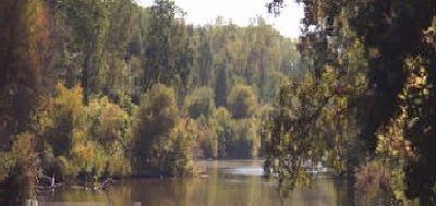
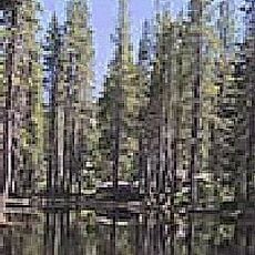
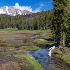
Butte Creek Ecological Reserve is a protected natural area spanning approximately 287 acres along Butte Creek with two separate units near Chico. The land contains riparian forests, oak woodlands, and numerous habitats that support different kinds of wildlife.

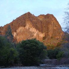
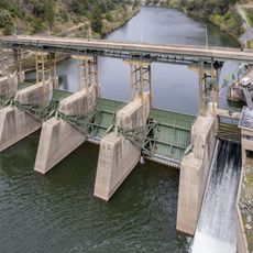
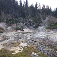
Mining for gold, sand, and gravel shaped the canyon from the mid-1800s until recent decades, significantly altering the landscape. The California Department of Fish and Wildlife eventually acquired the property to restore and protect the natural environment.

The land holds meaning for the Mechoopda Indian Tribe, who took ownership of the Honey Run Unit in 2023 and continue their ancestral ties to this territory. Walking through the forest and along the creek, you sense the ongoing connection between the tribe and this place.

The reserve is best explored on foot, with trails along the creek and through different habitats suited to various skill levels. Wear sturdy shoes and check seasonal conditions before your visit, as trail quality changes with weather and water levels.

The creek supports the largest population of Central Valley Spring Run Chinook salmon in the region, demonstrating remarkable recovery after habitat protection began. These fish depend on flowing water and healthy forest conditions that the reserve now provides.

Location: California

GPS coordinates: 40.08780,-121.41600

Latest update: December 14, 2025 17:02

Photos
Around this place
Lassen Peak
United States of America

Lassen Peak

45.2 km
Lake Almanor
United States of America

Lake Almanor

28.5 km
Mount Tehama
United States of America

Mount Tehama

41.6 km
Geothermal areas in Lassen Volcanic National Park
United States of America

Geothermal areas in Lassen Volcanic National Park

41.9 km
Ishi Wilderness
United States of America

Ishi Wilderness

29.3 km
Bucks Lake Wilderness
United States of America

Bucks Lake Wilderness

25.3 km
Drakesbad Guest Ranch
United States of America

Drakesbad Guest Ranch

39.7 km
Bucks Lake
United States of America

Bucks Lake

31.3 km
Poe Dam
United States of America

Poe Dam

31 km
Canyon Dam
United States of America

Canyon Dam

29.3 km
Pulga Bridges
United States of America

Pulga Bridges

32.8 km
Mount Harkness Fire Lookout
United States of America

Mount Harkness Fire Lookout

39.4 km
Tobin Bridges
United States of America

Tobin Bridges

18.9 km
Lassen Volcanic National Park Highway Historic District
United States of America

Lassen Volcanic National Park Highway Historic District

46.6 km
Park Headquarters, Lassen Volcanic National Park
United States of America

Park Headquarters, Lassen Volcanic National Park

33.1 km
Warner Valley Ranger Station
United States of America

Warner Valley Ranger Station

39.4 km
Horseshoe Lake Ranger Station
United States of America

Horseshoe Lake Ranger Station

43.5 km
Summit Lake Ranger Station
United States of America

Summit Lake Ranger Station

45.7 km
Sulphur Works
United States of America

Sulphur Works

41.5 km
Kohm Yah-mah-nee Visitor Center
United States of America

Kohm Yah-mah-nee Visitor Center

40.2 km
Bumpass Hell
United States of America

Bumpass Hell

41.8 km
Lassen Peak Trailhead
United States of America

Lassen Peak Trailhead

43.7 km
Sulphur Works
United States of America

Sulphur Works

41.5 km
Catfish Beach
United States of America

Catfish Beach

32.2 km
Lassen Volcanic Center
United States of America

Lassen Volcanic Center

45.7 km
Kings Creek
United States of America

Kings Creek

38.2 km
Summit Lake North Campground
United States of America

Summit Lake North Campground

45.3 km
Devils Kitchen
United States of America

Devils Kitchen

39.5 km
Show the full map
Reviews

Visited this place? Tap the stars to rate it and share your experience / photos with the community! Try now! You can cancel it anytime.

« Butte Creek Ecological Reserve - Protected natural area near Chico, California » is provided by Around Us (aroundus.com). Images and texts are derived from Wikimedia project under a Creative Commons license. You are allowed to copy, distribute, and modify copies of this page, under the conditions set by the license, as long as this note is clearly visible.

Discover hidden gems everywhere you go!

From secret cafés to breathtaking viewpoints, skip the crowded tourist spots and find places that match your style. Our app makes it easy with voice search, smart filtering, route optimization, and insider tips from travelers worldwide. Download now for the complete mobile experience.

Around Us App Screenshot

A unique approach to discovering new places

Le Figaro

All the places worth exploring

France Info

A tailor-made excursion in just a few clicks

20 Minutes