Chest opened
+${chestReward.xp} XP
Explorer
NOUVEAU ×${chestReward.collectible.quantity}
tapez pour fermer
Chest locked

Open chests in the app

Around Us is built for your phone — chests unlock when you walk, explore and capture nearby places.

Enable Location

We need your location to show you interesting places around you

Discover nearby places

Find interesting locations and hidden gems around you

Precise directions

Get accurate directions and distances to places

Your location is never shared with other users. It's only used when you tap the location button.

Infernal Caverns

Log in to your account

Start exploring — it's free

Trusted by 72,888 travelers worldwide

Continue with Google
Continue with Apple
or

We will send you a code to connect

By continuing, you accept our Terms and Conditions and our Privacy Policy

Check your inbox

We've sent a pincode in your inbox. Please enter the code below.

Infernal Caverns
Discussion Reviews 1 Photos
2.3k Popularity

Infernal Caverns, Historical battlefield memorial in Modoc County, California, United States.

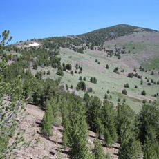
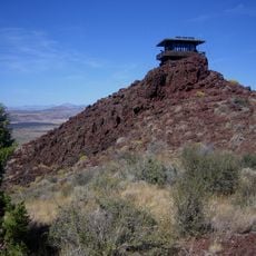
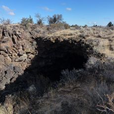
Infernal Caverns is a battlefield site featuring rocky cave formations on a steep hillside in northeastern California. The terrain consists of jagged rock faces and natural openings carved into the landscape.

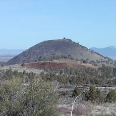
The site was the scene of a two-day conflict in September 1867 between U.S. Army forces and Native American forces. The cave formations provided crucial defensive advantages during the fighting.

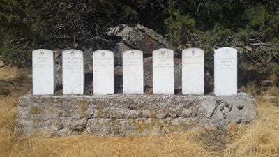
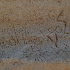
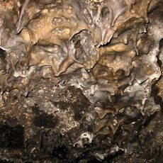
The site took its name from the cave formations that shaped the conflict. Six white marble tombstones stand here as markers for those who died during the engagement.

The site is located about 10 kilometers northwest of Likely along a county road in a remote area. Visitors should wear sturdy shoes and be prepared for uneven ground when exploring the rocky terrain.

The caves served as an unusually effective natural fortress for the period. The formation allowed a smaller group to hold out against a numerically superior force.

The community of curious travelers

AroundUs brings together thousands of curated places, local tips, and hidden gems, enriched daily by 60,000 contributors worldwide.

Start exploring
GPS coordinates
41.27222,-120.57611
Latest update
December 13, 2025 11:40
Around this place
Burney Falls
United States of America

Burney Falls

94.7 km
Allen Telescope Array
United States of America

Allen Telescope Array

90.7 km
Medicine Lake Volcano
United States of America

Medicine Lake Volcano

92.1 km
McArthur-Burney Falls Memorial State Park
United States of America

McArthur-Burney Falls Memorial State Park

94.4 km
Modoc National Forest
United States of America

Modoc National Forest

57.9 km
Ahjumawi Lava Springs State Park
United States of America

Ahjumawi Lava Springs State Park

72.1 km
Hat Creek Radio Observatory
United States of America

Hat Creek Radio Observatory

90.7 km
Clear Lake National Wildlife Refuge
United States of America

Clear Lake National Wildlife Refuge

79.2 km
South Warner Wilderness
United States of America

South Warner Wilderness

33.3 km
Modoc National Wildlife Refuge
United States of America

Modoc National Wildlife Refuge

21.1 km
Eagle Peak
United States of America

Eagle Peak

31.4 km
Petroglyph Point Archaeological Site
United States of America

Petroglyph Point Archaeological Site

93.1 km
Goose Lake State Recreation Area
United States of America

Goose Lake State Recreation Area

83.1 km
Schonchin Butte
United States of America

Schonchin Butte

94.9 km
High Rock Canyon Wilderness
United States of America

High Rock Canyon Wilderness

94.6 km
Goose Lake meteorite
United States of America

Goose Lake meteorite

78.8 km
Fort Crook
United States of America

Fort Crook

81.2 km
Dodge Reservoir
United States of America

Dodge Reservoir

50 km
Hat Mountain
United States of America

Hat Mountain

40.1 km
Jess Valley Schoolhouse
United States of America

Jess Valley Schoolhouse

22.2 km
Schonchin Butte Lookout
United States of America

Schonchin Butte Lookout

94.9 km
Skull Cave
United States of America

Skull Cave

93.2 km
Mushpot Cave
United States of America

Mushpot Cave

92 km
Intermountain Fair
United States of America

Intermountain Fair

73.3 km
Lava Beds Visitor Center
United States of America

Lava Beds Visitor Center

92.1 km
Fort Crook Museum
United States of America

Fort Crook Museum

78.8 km
Niles Theater
United States of America

Niles Theater

23.7 km
Sandy Beach
United States of America

Sandy Beach

67.1 km
Show the full map
Reviews
Share your experience

No review yet

Discussions
Start a discussion...

No discussion yet

« Infernal Caverns - Historical battlefield memorial in Modoc County, California, United States » is provided by Around Us (aroundus.com). Images and texts are derived from Wikimedia project under a Creative Commons license. You are allowed to copy, distribute, and modify copies of this page, under the conditions set by the license, as long as this note is clearly visible.

Discover hidden gems everywhere you go!

From secret cafés to breathtaking viewpoints, skip the crowded tourist spots and find places that match your style. Our app makes it easy with voice search, smart filtering, route optimization, and insider tips from travelers worldwide. Download now for the complete mobile experience.

Around Us App Screenshot

A unique approach to discovering new places

Le Figaro

All the places worth exploring

France Info

A tailor-made excursion in just a few clicks

20 Minutes

Around Us
Travel Guide & Maps
Download

Send to your phone

QR Code
1

Open the camera app on your mobile.

2

Point at the QR code with your camera. A notification will appear.

3

Tap the notification to open the link.