Chest opened
+${chestReward.xp} XP
Explorer
NOUVEAU ×${chestReward.collectible.quantity}
tapez pour fermer
Chest locked

Open chests in the app

Around Us is built for your phone — chests unlock when you walk, explore and capture nearby places.

Enable Location

We need your location to show you interesting places around you

Discover nearby places

Find interesting locations and hidden gems around you

Precise directions

Get accurate directions and distances to places

Your location is never shared with other users. It's only used when you tap the location button.

Log in to your account

Start exploring — it's free

Trusted by 72,887 travelers worldwide

Continue with Google
Continue with Apple
or

We will send you a code to connect

By continuing, you accept our Terms and Conditions and our Privacy Policy

Check your inbox

We've sent a pincode in your inbox. Please enter the code below.

Eagle Creek Upper Falls
Discussion Reviews Photo
1.7k Popularity

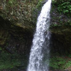
Eagle Creek Upper Falls, Waterfall in Clackamas County, Oregon, United States

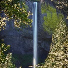
Eagle Creek Upper Falls is a waterfall in Clackamas County that drops over rock faces into a narrow canyon below. The water cascades in stages, creating a layered descent through forested terrain where moss and mist accumulate along the rocks.

The waterfall was officially registered in the Geographic Names Information System in 2018, giving it formal recognition on maps. This registration made it easier for hikers and geographers to locate and document the site.

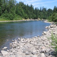
The waterfall functions as a crucial part of the local ecosystem, supporting populations of chinook salmon, bull trout, and steelhead trout in Eagle Creek.

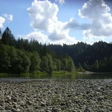
The area is accessible through established hiking trails that wind through forests along Eagle Creek. The ground can be wet and slippery, particularly after rain, so sturdy footwear is important.

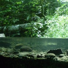
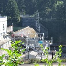
The site contains a fish ladder that helps salmon navigate upstream during their migration season. This installation demonstrates how human infrastructure works to support natural migration routes for wildlife.

The community of curious travelers

AroundUs brings together thousands of curated places, local tips, and hidden gems, enriched daily by 60,000 contributors worldwide.

Start exploring
Location
GPS coordinates
45.27750,-122.19556
Latest update
December 14, 2025 12:22
Around this place
Crown Point
United States of America

Crown Point

29.4 km
Boring Lava Field
United States of America

Boring Lava Field

24 km
Latourell Falls
United States of America

Latourell Falls

28.9 km
Larch Mountain
United States of America

Larch Mountain

29.4 km
Milo McIver State Park
United States of America

Milo McIver State Park

14.3 km
Oxbow Regional Park
United States of America

Oxbow Regional Park

25.3 km
Wildwood Recreation Site
United States of America

Wildwood Recreation Site

17.7 km
View Point Inn
United States of America

View Point Inn

28.7 km
Guy W. Talbot State Park
United States of America

Guy W. Talbot State Park

28.8 km
Camp Namanu
United States of America

Camp Namanu

19.2 km
Philip Foster Farm
United States of America

Philip Foster Farm

15.3 km
United States of America

Salmon–Huckleberry Wilderness

17.1 km
United States of America

North Fork Reservoir

6.8 km
Dabney State Recreation Area
United States of America

Dabney State Recreation Area

29.3 km
Bonnie Lure State Recreation Area
United States of America

Bonnie Lure State Recreation Area

16.5 km
River Mill Hydroelectric Project
United States of America

River Mill Hydroelectric Project

12.4 km
Zigzag Ranger Station
United States of America

Zigzag Ranger Station

21.1 km
George W. Joseph State Natural Area
United States of America

George W. Joseph State Natural Area

28.2 km
Zigzag Mountain
United States of America

Zigzag Mountain

29 km
Horace Baker Log Cabin
United States of America

Horace Baker Log Cabin

9.4 km
St. John the Evangelist Roman Catholic Church
United States of America

St. John the Evangelist Roman Catholic Church

20.6 km
Springdale School
United States of America

Springdale School

28.9 km
Andreas Graf House
United States of America

Andreas Graf House

26 km
Emanuel and Christina Anderson House
United States of America

Emanuel and Christina Anderson House

29 km
R. S. Smith Motor Company Building
United States of America

R. S. Smith Motor Company Building

14.1 km
Lusted Road Bridge
United States of America

Lusted Road Bridge

19.2 km
Damascus School
United States of America

Damascus School

25.7 km
North American Bigfoot Center
United States of America

North American Bigfoot Center

20.6 km
Show the full map
Reviews
Share your experience

No review yet

Discussions
Start a discussion...

No discussion yet

« Eagle Creek Upper Falls - Waterfall in Clackamas County, Oregon, United States » is provided by Around Us (aroundus.com). Images and texts are derived from Wikimedia project under a Creative Commons license. You are allowed to copy, distribute, and modify copies of this page, under the conditions set by the license, as long as this note is clearly visible.

Discover hidden gems everywhere you go!

From secret cafés to breathtaking viewpoints, skip the crowded tourist spots and find places that match your style. Our app makes it easy with voice search, smart filtering, route optimization, and insider tips from travelers worldwide. Download now for the complete mobile experience.

Around Us App Screenshot

A unique approach to discovering new places

Le Figaro

All the places worth exploring

France Info

A tailor-made excursion in just a few clicks

20 Minutes

Around Us
Travel Guide & Maps
Download

Send to your phone

QR Code
1

Open the camera app on your mobile.

2

Point at the QR code with your camera. A notification will appear.

3

Tap the notification to open the link.