Pisgah Crater

Log in to your account

AroundUs is a community-driven map of interesting places, built by curious explorers like you. It grows with every review, story, and photo you share.
Connect to save your favorite spots, contribute locations, and create personalized routes.
Continue with Google
Continue with Apple
Continue with X
Continue with Facebook
Continue with email
By continuing, you accept our Terms and Conditions and our Privacy Policy
Create an account
Add to collection
Map
Suggest a change
Share

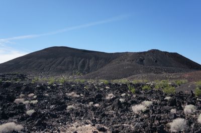
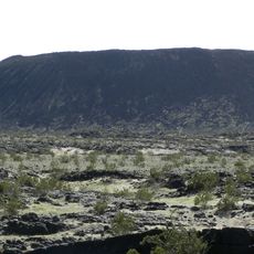
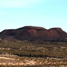
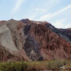
Pisgah Crater, Volcanic cinder cone in San Bernardino County, California.

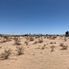
Pisgah Crater is a volcanic cone in the Mojave Desert of San Bernardino County, California. Black lava fields spread from the summit into the flat desert landscape, forming a dark band of solidified rock.

The last eruption occurred around 2000 years ago, leaving fresh lava flows across the desert. In the decades before protection status in 1973, mining companies removed cinder material from the cone for railroad construction.

University geology classes and professional groups conduct regular field studies at the crater, examining volcanic formations and mineral compositions.

Visitors follow a short trail from the parking area to the crater rim and can climb on the eastern side. Light clothing, sturdy footwear, and several liters of water are essential in the desert heat.

Geologists use the site regularly for field trips because both main types of cooled lava occur side by side in one location. Stalactites made of gypsum have formed inside some cavities within the lava tubes.

Location: California

GPS coordinates: 34.74638,-116.37558

Latest update: December 5, 2025 22:29

Photos
Around this place
Integratron
United States of America

Integratron

50.4 km
Lake Dolores Waterpark
United States of America

Lake Dolores Waterpark

36.3 km
Rancho De La Luna
United States of America

Rancho De La Luna

67.6 km
Amboy Crater
United States of America

Amboy Crater

58.1 km
Calico Early Man Site
United States of America

Calico Early Man Site

41.8 km
Kelso Dunes
United States of America

Kelso Dunes

58.3 km
World's Tallest Thermometer
United States of America

World's Tallest Thermometer

64.1 km
Big Bear Solar Observatory
United States of America

Big Bear Solar Observatory

73.9 km
Mojave Trails National Monument
United States of America

Mojave Trails National Monument

41.4 km
Rainbow Basin
United States of America

Rainbow Basin

68.1 km
Lavic Lake volcanic field
United States of America

Lavic Lake volcanic field

53 m
Liberty Sculpture Park
United States of America

Liberty Sculpture Park

46.3 km
Big Bear Discovery Center
United States of America

Big Bear Discovery Center

72.4 km
Calico and Odessa Railroad
United States of America

Calico and Odessa Railroad

50 km
Western America Railroad Museum
United States of America

Western America Railroad Museum

61.9 km
Desert Christ Park
United States of America

Desert Christ Park

69 km
Goode Solar Telescope
United States of America

Goode Solar Telescope

73.9 km
Bagdad Cafe
United States of America

Bagdad Cafe

25.8 km
World Famous Crochet Museum
United States of America

World Famous Crochet Museum

68.4 km
Hi-Desert Nature Museum
United States of America

Hi-Desert Nature Museum

69.4 km
Joshua Tree National Park Visitor Center
United States of America

Joshua Tree National Park Visitor Center

74.1 km
Calikage Playhouse
United States of America

Calikage Playhouse

50.1 km
Joshua Tree Visitor Center
United States of America

Joshua Tree Visitor Center

68.4 km
Black Rock Nature Center
United States of America

Black Rock Nature Center

74.9 km
Beauty Bubble Salon and Museum
United States of America

Beauty Bubble Salon and Museum

68.3 km
Black Rock Campground
United States of America

Black Rock Campground

74.9 km
Indian Cove Campground Amphitheater
United States of America

Indian Cove Campground Amphitheater

75.1 km
Afton Canyon
United States of America

Afton Canyon

34.1 km
Show the full map
Reviews

Visited this place? Tap the stars to rate it and share your experience / photos with the community! Try now! You can cancel it anytime.

« Pisgah Crater - Volcanic cinder cone in San Bernardino County, California » is provided by Around Us (aroundus.com). Images and texts are derived from Wikimedia project under a Creative Commons license. You are allowed to copy, distribute, and modify copies of this page, under the conditions set by the license, as long as this note is clearly visible.

Discover hidden gems everywhere you go!

From secret cafés to breathtaking viewpoints, skip the crowded tourist spots and find places that match your style. Our app makes it easy with voice search, smart filtering, route optimization, and insider tips from travelers worldwide. Download now for the complete mobile experience.

Around Us App Screenshot

A unique approach to discovering new places

Le Figaro

All the places worth exploring

France Info

A tailor-made excursion in just a few clicks

20 Minutes