Enable Location

We need your location to show you interesting places around you

Discover nearby places

Find interesting locations and hidden gems around you

Precise directions

Get accurate directions and distances to places

Your location is never shared with other users. It's only used when you tap the location button.

Lake Dolores Waterpark

Log in to your account

Start exploring — it's free

Trusted by 62,056 travelers worldwide

Continue with Google
Continue with Apple
or

We will send you a code to connect

By continuing, you accept our Terms and Conditions and our Privacy Policy

Check your inbox

We've sent a pincode in your inbox. Please enter the code below.

Lake Dolores Waterpark

Lake Dolores Waterpark, Water park in Mojave Desert, California.

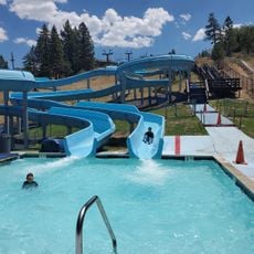
Lake Dolores Waterpark is an abandoned recreational complex in the Mojave Desert between Los Angeles and Las Vegas. The structures include several empty pools, slides of different heights, and artificial water features now standing idle among the dry hills.

Businessman Bob Byers opened the park in 1962 and named it after his wife Dolores. After multiple ownership changes and renamings, the facility closed its doors permanently in 2004.

The site has served as a filming location for several American movies and music videos depicting post-apocalyptic scenes. The abandoned pools and colorful slide towers now stand in contrast to the bare desert surroundings.

The site sits directly beside Interstate 15 roughly halfway between Los Angeles and Las Vegas. Access is not officially regulated, but entering is at your own risk due to unstable structures and lack of safety measures.

Skateboarder Rob Dyrdek used the empty pools in 2008 for an episode of his MTV series. The colorful graffiti and artworks that have since been added turn the place into a sort of open-air gallery.

The community of curious travelers

AroundUs brings together thousands of curated places, local tips, and hidden gems, enriched daily by 60,000 contributors worldwide.

Start exploring
Location
Official opening
May 1962
GPS coordinates
34.94820,-116.68700
Latest update
December 14, 2025 17:42
Around this place
Deep Space Network
United States of America

Deep Space Network

56.4 km
Integratron
United States of America

Integratron

77.3 km
Big Bear Lake
United States of America

Big Bear Lake

83 km
Goldstone Deep Space Communications Complex
United States of America

Goldstone Deep Space Communications Complex

56.4 km
Calico Early Man Site
United States of America

Calico Early Man Site

6.8 km
Pisgah Crater
United States of America

Pisgah Crater

36.3 km
World's Tallest Thermometer
United States of America

World's Tallest Thermometer

66.2 km
Deep Creek Hot Springs
United States of America

Deep Creek Hot Springs

81.3 km
Big Bear Solar Observatory
United States of America

Big Bear Solar Observatory

79.7 km
Mojave Trails National Monument
United States of America

Mojave Trails National Monument

75.9 km
Rainbow Basin
United States of America

Rainbow Basin

33.2 km
Lavic Lake volcanic field
United States of America

Lavic Lake volcanic field

36.3 km
Liberty Sculpture Park
United States of America

Liberty Sculpture Park

14.8 km
Goldstone Solar System Radar
United States of America

Goldstone Solar System Radar

56.4 km
Alpine Slide
United States of America

Alpine Slide

81.9 km
Big Bear Discovery Center
United States of America

Big Bear Discovery Center

78.8 km
California Route 66 Museum
United States of America

California Route 66 Museum

72 km
Calico and Odessa Railroad
United States of America

Calico and Odessa Railroad

16.1 km
Western America Railroad Museum
United States of America

Western America Railroad Museum

31.2 km
Big Bear Snow Play
United States of America

Big Bear Snow Play

78.5 km
Bristol Mountains
United States of America

Bristol Mountains

58.7 km
Rodman Mountains
United States of America

Rodman Mountains

28.1 km
Goode Solar Telescope
United States of America

Goode Solar Telescope

79.7 km
Desert Lighthouse
United States of America

Desert Lighthouse

48 km
Bagdad Cafe
United States of America

Bagdad Cafe

14.9 km
DSS 14
United States of America

DSS 14

56.3 km
DSS 13
United States of America

DSS 13

56.3 km
Calikage Playhouse
United States of America

Calikage Playhouse

16.3 km
Show the full map
« Lake Dolores Waterpark - Water park in Mojave Desert, California » is provided by Around Us (aroundus.com). Images and texts are derived from Wikimedia project under a Creative Commons license. You are allowed to copy, distribute, and modify copies of this page, under the conditions set by the license, as long as this note is clearly visible.

Discover hidden gems everywhere you go!

From secret cafés to breathtaking viewpoints, skip the crowded tourist spots and find places that match your style. Our app makes it easy with voice search, smart filtering, route optimization, and insider tips from travelers worldwide. Download now for the complete mobile experience.

Around Us App Screenshot

A unique approach to discovering new places

Le Figaro

All the places worth exploring

France Info

A tailor-made excursion in just a few clicks

20 Minutes

Around Us
Travel Guide & Maps
Download

Send to your phone

QR Code
1

Open the camera app on your mobile.

2

Point at the QR code with your camera. A notification will appear.

3

Tap the notification to open the link.