Enable Location

We need your location to show you interesting places around you

Discover nearby places

Find interesting locations and hidden gems around you

Precise directions

Get accurate directions and distances to places

Your location is never shared with other users. It's only used when you tap the location button.

Rodman Mountains

Log in to your account

Start exploring — it's free

Trusted by 60,652 travelers worldwide

Continue with Google
Continue with Apple
or

We will send you a code to connect

By continuing, you accept our Terms and Conditions and our Privacy Policy

Check your inbox

We've sent a pincode in your inbox. Please enter the code below.

Rodman Mountains

Rodman Mountains, Protected mountain range in Mojave Desert, California, US

Description

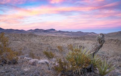
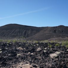
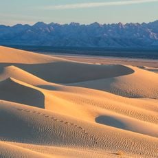
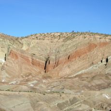
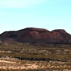
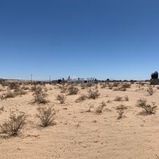
Rodman Mountains is a mountain range in the Mojave Desert covering thousands of acres with colorful escarpments, white peaks marked by red patches, and intricate canyon systems. The terrain rises to considerable elevations and contains diverse geological formations shaped over long periods of time.

History

The United States Congress protected this area in 1994, placing it under Bureau of Land Management supervision through protective legislation. This action recognized the region's ecological and historical value and secured its preservation for future generations.

Culture

Ancient rock carvings cover basalt surfaces throughout the region, particularly concentrated in a narrow canyon where visitors can observe traces of earlier inhabitants. These markings tell of people who lived here long ago and viewed the landscape as sacred.

Practical

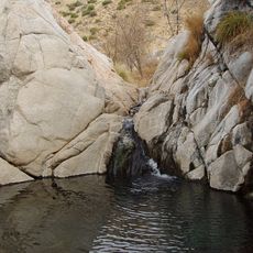
The area contains natural water tanks formed in lava rock that hold water throughout the year and are important for hikers and other visitors. Visitors should be prepared for the harsh desert environment and bring adequate supplies for exploration.

Did you know?

The region is one of only seven core breeding territories for raptors in the entire Mojave Desert. Prairie falcons and golden eagles actively raise their young here, making this area a rare refuge for these birds of prey.

Location
Elevation above the sea
1,323 m
GPS coordinates
34.70000,-116.63400
Latest update
December 13, 2025 17:04

AroundUs brings together thousands of curated places, local tips, and hidden gems, enriched daily by 60,000 contributors worldwide. Discover all places nearby (California).

Around this place
Integratron
United States of America

Integratron

49.8 km
San Gorgonio Mountain
United States of America

San Gorgonio Mountain

69.1 km
Lake Dolores Waterpark
United States of America

Lake Dolores Waterpark

28.1 km
Big Bear Lake
United States of America

Big Bear Lake

59.9 km
Rancho De La Luna
United States of America

Rancho De La Luna

68.5 km
Calico Early Man Site
United States of America

Calico Early Man Site

30 km
San Bernardino National Forest
United States of America

San Bernardino National Forest

132.4 km
Pisgah Crater
United States of America

Pisgah Crater

24.2 km
Deep Creek Hot Springs
United States of America

Deep Creek Hot Springs

64 km
Big Bear Solar Observatory
United States of America

Big Bear Solar Observatory

55.8 km
Mojave Trails National Monument
United States of America

Mojave Trails National Monument

64.1 km
Rainbow Basin
United States of America

Rainbow Basin

52 km
Lavic Lake volcanic field
United States of America

Lavic Lake volcanic field

24.3 km
Liberty Sculpture Park
United States of America

Liberty Sculpture Park

30 km
Big Bear Discovery Center
United States of America

Big Bear Discovery Center

54.6 km
California Route 66 Museum
United States of America

California Route 66 Museum

63.2 km
Calico and Odessa Railroad
United States of America

Calico and Odessa Railroad

34.8 km
Western America Railroad Museum
United States of America

Western America Railroad Museum

42.3 km
Desert Christ Park
United States of America

Desert Christ Park

66 km
Goode Solar Telescope
United States of America

Goode Solar Telescope

55.8 km
Desert Lighthouse
United States of America

Desert Lighthouse

60.1 km
Bagdad Cafe
United States of America

Bagdad Cafe

13.3 km
Jepson Peak
United States of America

Jepson Peak

69.2 km
World Famous Crochet Museum
United States of America

World Famous Crochet Museum

69.5 km
Hi-Desert Nature Museum
United States of America

Hi-Desert Nature Museum

67.1 km
Calikage Playhouse
United States of America

Calikage Playhouse

34.9 km
Joshua Tree Visitor Center
United States of America

Joshua Tree Visitor Center

69.5 km
Beauty Bubble Salon and Museum
United States of America

Beauty Bubble Salon and Museum

69.5 km
Show the full map
« Rodman Mountains - Protected mountain range in Mojave Desert, California, US » is provided by Around Us (aroundus.com). Images and texts are derived from Wikimedia project under a Creative Commons license. You are allowed to copy, distribute, and modify copies of this page, under the conditions set by the license, as long as this note is clearly visible.

Discover hidden gems everywhere you go!

From secret cafés to breathtaking viewpoints, skip the crowded tourist spots and find places that match your style. Our app makes it easy with voice search, smart filtering, route optimization, and insider tips from travelers worldwide. Download now for the complete mobile experience.

Around Us App Screenshot

A unique approach to discovering new places

Le Figaro

All the places worth exploring

France Info

A tailor-made excursion in just a few clicks

20 Minutes

Around Us
Travel Guide & Maps
Download

Send to your phone

QR Code
1

Open the camera app on your mobile.

2

Point at the QR code with your camera. A notification will appear.

3

Tap the notification to open the link.