Kelso Dunes

Log in to your account

AroundUs is a community-driven map of interesting places, built by curious explorers like you. It grows with every review, story, and photo you share.
Connect to save your favorite spots, contribute locations, and create personalized routes.
Continue with Google
Continue with Apple
Continue with X
Continue with Facebook
Continue with email
By continuing, you accept our Terms and Conditions and our Privacy Policy
Create an account
Add to collection
Map
Suggest a change
Share

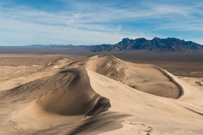
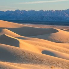
Kelso Dunes, Sand dune field in Mojave National Preserve, California.

Kelso Dunes is a sand dune field in the Mojave Desert with sand formations rising steeply above the surrounding plain. The area spreads across multiple kilometers of rolling terrain composed of fine sand sculpted by wind into different shapes and heights.

The dunes formed thousands of years ago when an ancient lake dried up and wind transported the exposed sediments into large sand mounds. This process reshaped the landscape as desert conditions continued to evolve.

The dunes served as navigation points for Mojave people moving through the desert landscape. Visitors walking across the sand can still sense how these formations shaped the routes and rhythms of traditional desert travel.

Visitors should arrive early in the morning when temperatures are still manageable and bring plenty of water for the hike. The terrain is demanding and the midday heat can quickly become exhausting.

When people slide down the sandy slopes, the dunes emit a deep, resonant sound, a rare acoustic phenomenon among dunes in North America. This booming effect occurs at only a handful of other dune fields on the continent.

Location: San Bernardino County

Part of: Mojave Desert

GPS coordinates: 34.90913,-115.76940

Latest update: December 7, 2025 10:04

Photos
Around this place
Interstate 40
United States of America

Interstate 40

45.2 km
Integratron
United States of America

Integratron

89.8 km
Lake Dolores Waterpark
United States of America

Lake Dolores Waterpark

83.9 km
United States of America

AN/URC-117 Ground Wave Emergency Network

52.3 km
Amboy Crater
United States of America

Amboy Crater

40.7 km
Calico Early Man Site
United States of America

Calico Early Man Site

90.6 km
Desperado
United States of America

Desperado

86 km
Interstate 40 in California
United States of America

Interstate 40 in California

83.1 km
Pisgah Crater
United States of America

Pisgah Crater

58.3 km
World's Tallest Thermometer
United States of America

World's Tallest Thermometer

48.4 km
Mitchell Caverns
United States of America

Mitchell Caverns

23.5 km
Castle Mountains National Monument
United States of America

Castle Mountains National Monument

76.9 km
Mojave Trails National Monument
United States of America

Mojave Trails National Monument

31.8 km
Lavic Lake volcanic field
United States of America

Lavic Lake volcanic field

58.2 km
Mojave Memorial Cross
United States of America

Mojave Memorial Cross

49.4 km
Cima Dome & Volcanic Field National Natural Landmark
United States of America

Cima Dome & Volcanic Field National Natural Landmark

38 km
Old Woman meteorite
United States of America

Old Woman meteorite

61.6 km
Old Woman Mountains Wilderness
United States of America

Old Woman Mountains Wilderness

72.4 km
Providence Mountains State Recreation Area
United States of America

Providence Mountains State Recreation Area

24.2 km
Clark Mountain
United States of America

Clark Mountain

70.5 km
Bigelow Cholla Garden Wilderness
United States of America

Bigelow Cholla Garden Wilderness

80.7 km
Clipper Mountain Wilderness
United States of America

Clipper Mountain Wilderness

37.3 km
Dead Mountains
United States of America

Dead Mountains

94.7 km
Goffs Schoolhouse
United States of America

Goffs Schoolhouse

65.2 km
Bagdad Cafe
United States of America

Bagdad Cafe

80.4 km
Wee Thump Joshua Tree Wilderness, Nevada
United States of America

Wee Thump Joshua Tree Wilderness, Nevada

92.4 km
Joshua Tree National Park Visitor Center
United States of America

Joshua Tree National Park Visitor Center

90.1 km
Afton Canyon
United States of America

Afton Canyon

49.4 km
Show the full map
Reviews

Visited this place? Tap the stars to rate it and share your experience / photos with the community! Try now! You can cancel it anytime.

« Kelso Dunes - Sand dune field in Mojave National Preserve, California » is provided by Around Us (aroundus.com). Images and texts are derived from Wikimedia project under a Creative Commons license. You are allowed to copy, distribute, and modify copies of this page, under the conditions set by the license, as long as this note is clearly visible.

Discover hidden gems everywhere you go!

From secret cafés to breathtaking viewpoints, skip the crowded tourist spots and find places that match your style. Our app makes it easy with voice search, smart filtering, route optimization, and insider tips from travelers worldwide. Download now for the complete mobile experience.

Around Us App Screenshot

A unique approach to discovering new places

Le Figaro

All the places worth exploring

France Info

A tailor-made excursion in just a few clicks

20 Minutes