Enable Location

We need your location to show you interesting places around you

Discover nearby places

Find interesting locations and hidden gems around you

Precise directions

Get accurate directions and distances to places

Your location is never shared with other users. It's only used when you tap the location button.

Log in to your account

Start exploring — it's free

Trusted by 63,045 travelers worldwide

Continue with Google
Continue with Apple
or

We will send you a code to connect

By continuing, you accept our Terms and Conditions and our Privacy Policy

Check your inbox

We've sent a pincode in your inbox. Please enter the code below.

Doherty Slide
Discussion Reviews Photo
1.8k Popularity

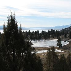
Doherty Slide, Protected area in Lake County, Oregon.

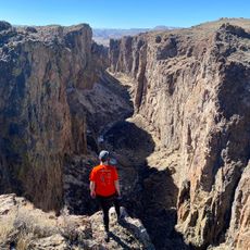
Doherty Slide is a volcanic ridge in southeastern Oregon near the Nevada border where Oregon Route 140 crosses at elevation. The formation rises steeply about 1000 feet from the valley floor and creates a dramatic geological barrier in this remote high desert region.

The ridge formed from ancient lava flows that built up a high wall, which erosion then shaped into its present form. The road was built to cross this steep terrain and connect remote areas in southeastern Oregon.

The Doherty Slide represents a testament to road engineering, where a highway navigates through severe geological constraints in the American West.

The road is narrow and two-lane with a steep grade, so careful driving is essential especially in bad weather or with large vehicles. There are no guard rails on this stretch, so drivers should stay focused and respect the road edges.

The eastern side of the formation connects to a high plateau stretching across much of southeastern Oregon. On the opposite side the terrain drops sharply into Guano Valley, creating two very different landscapes within a short distance.

The community of curious travelers

AroundUs brings together thousands of curated places, local tips, and hidden gems, enriched daily by 60,000 contributors worldwide.

Start exploring
Location
GPS coordinates
42.03680,-119.48300
Latest update
December 14, 2025 12:25
Around this place
Sheldon National Wildlife Refuge
United States of America

Sheldon National Wildlife Refuge

31.3 km
Hart Mountain National Antelope Refuge
United States of America

Hart Mountain National Antelope Refuge

58.8 km
Abert Rim
United States of America

Abert Rim

73.3 km
David L. Shirk Ranch
United States of America

David L. Shirk Ranch

22.7 km
Fandango Pass
United States of America

Fandango Pass

65.4 km
Greaser Petroglyph Site
United States of America

Greaser Petroglyph Site

31.4 km
Camp Warner
United States of America

Camp Warner

48.3 km
Goose Lake State Recreation Area
United States of America

Goose Lake State Recreation Area

69.6 km
High Rock Canyon Wilderness
United States of America

High Rock Canyon Wilderness

72.5 km
Stone Bridge and the Oregon Central Military Wagon Road
United States of America

Stone Bridge and the Oregon Central Military Wagon Road

46 km
Deep Creek Falls
United States of America

Deep Creek Falls

41.5 km
Heryford Brothers Building
United States of America

Heryford Brothers Building

73.3 km
Lake County Round Sale Barn
United States of America

Lake County Round Sale Barn

74.6 km
Bailey and Massingill Store
United States of America

Bailey and Massingill Store

73.2 km
John N. and Cornelia Watson House
United States of America

John N. and Cornelia Watson House

73.5 km
William P. Heryford House
United States of America

William P. Heryford House

73.2 km
BLM Field Camp
United States of America

BLM Field Camp

22.4 km
BLM Field Camp
United States of America

BLM Field Camp

44.5 km
Thousand Creek Gorge
United States of America

Thousand Creek Gorge

45.7 km
United States of America

Crane Mountain Viewpoint

63 km
United States of America

Hart Mountain Hot Springs

54.4 km
United States of America

Thousand Creek Gorge Viewpoint

45.4 km
United States of America

Lookout Point

51 km
United States of America

Scenic viewpoint, mountain, summit, hill

63 km
United States of America

L

72.7 km
United States of America

North Warner Viewpoint

68.1 km
United States of America

Scenic viewpoint

63.2 km
United States of America

Scenic viewpoint

63.1 km
Show the full map
Reviews
Share your experience

No review yet

Discussions
Start a discussion...

No discussion yet

« Doherty Slide - Protected area in Lake County, Oregon » is provided by Around Us (aroundus.com). Images and texts are derived from Wikimedia project under a Creative Commons license. You are allowed to copy, distribute, and modify copies of this page, under the conditions set by the license, as long as this note is clearly visible.

Discover hidden gems everywhere you go!

From secret cafés to breathtaking viewpoints, skip the crowded tourist spots and find places that match your style. Our app makes it easy with voice search, smart filtering, route optimization, and insider tips from travelers worldwide. Download now for the complete mobile experience.

Around Us App Screenshot

A unique approach to discovering new places

Le Figaro

All the places worth exploring

France Info

A tailor-made excursion in just a few clicks

20 Minutes

Around Us
Travel Guide & Maps
Download

Send to your phone

QR Code
1

Open the camera app on your mobile.

2

Point at the QR code with your camera. A notification will appear.

3

Tap the notification to open the link.