Stone Bridge and the Oregon Central Military Wagon Road

Log in to your account

AroundUs is a community-driven map of interesting places, built by curious explorers like you. It grows with every review, story, and photo you share.
Connect to save your favorite spots, contribute locations, and create personalized routes.
By continuing, you accept our Terms and Conditions and our Privacy Policy
Add to collection
Map
Suggest a change
Share

Stone Bridge and the Oregon Central Military Wagon Road, Military road bridge in Plush, Oregon

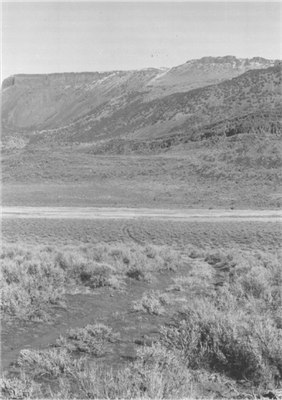
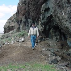
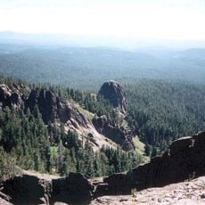
The Stone Bridge is a road bridge in Lake County, Oregon, consisting of a roughly quarter-mile elevated causeway built from basalt rocks dragged into place by hand. The structure connects two lakes and formed part of a military transportation route that helped the Army move across this isolated region.

The United States Army built this structure in 1867 to connect two lakes and later integrated it with a military transportation route. After a nearby fort closed in the late 1870s, local ranchers kept using this causeway for their own purposes.

The bridge reflects how military construction shaped a remote frontier region, showing the practical methods settlers used to navigate challenging landscapes.

This site is located in a remote area accessible via rough roads that can become difficult depending on the season. Visitors should expect unpaved terrain and bring appropriate clothing for changing weather conditions.

Building this structure required workers to haul heavy basalt boulders over long distances from nearby Hart Mountain, which was remarkable given the primitive equipment of the era. This manual method reveals the limits of early engineering efforts in remote wilderness.

Location: Lake County

GPS coordinates: 42.35470,-119.83900

Latest update: December 13, 2025 12:20

Photos
Around this place
Paisley Caves
United States of America

Paisley Caves

73.9 km
Summer Lake Hot Springs
United States of America

Summer Lake Hot Springs

78.1 km
Sheldon National Wildlife Refuge
United States of America

Sheldon National Wildlife Refuge

77.2 km
Hart Mountain National Antelope Refuge
United States of America

Hart Mountain National Antelope Refuge

26.4 km
Steens Mountain Wilderness
United States of America

Steens Mountain Wilderness

95.8 km
Summer Lake Wildlife Area
United States of America

Summer Lake Wildlife Area

100.7 km
Gearhart Mountain Wilderness
United States of America

Gearhart Mountain Wilderness

85.9 km
Abert Rim
United States of America

Abert Rim

32.7 km
David L. Shirk Ranch
United States of America

David L. Shirk Ranch

29.3 km
Frenchglen Hotel State Heritage Site
United States of America

Frenchglen Hotel State Heritage Site

92.2 km
Greaser Petroglyph Site
United States of America

Greaser Petroglyph Site

19.3 km
P Ranch
United States of America

P Ranch

94.1 km
Camp Warner
United States of America

Camp Warner

12.3 km
Goose Lake State Recreation Area
United States of America

Goose Lake State Recreation Area

56.6 km
Chandler State Wayside
United States of America

Chandler State Wayside

37.5 km
Hunter's Hot Springs
United States of America

Hunter's Hot Springs

46.1 km
Gerber Reservoir
United States of America

Gerber Reservoir

105.5 km
Booth State Scenic Corridor
United States of America

Booth State Scenic Corridor

63.9 km
Goose Lake meteorite
United States of America

Goose Lake meteorite

71.4 km
Deep Creek Falls
United States of America

Deep Creek Falls

22.1 km
Bly Ranger Station
United States of America

Bly Ranger Station

99.4 km
Lake County Round Sale Barn
United States of America

Lake County Round Sale Barn

46.5 km
John N. and Cornelia Watson House
United States of America

John N. and Cornelia Watson House

45.8 km
William P. Heryford House
United States of America

William P. Heryford House

45.7 km
Alger Theatre
United States of America

Alger Theatre

45.7 km
Star Theater
United States of America

Star Theater

99.2 km
BLM Field Camp
United States of America

BLM Field Camp

52.3 km
BLM Field Camp
United States of America

BLM Field Camp

40 km
Show the full map
Reviews

Visited this place? Tap the stars to rate it and share your experience / photos with the community! Try now! You can cancel it anytime.

« Stone Bridge and the Oregon Central Military Wagon Road - Military road bridge in Plush, Oregon » is provided by Around Us (aroundus.com). Images and texts are derived from Wikimedia project under a Creative Commons license. You are allowed to copy, distribute, and modify copies of this page, under the conditions set by the license, as long as this note is clearly visible.

Discover hidden gems everywhere you go!

From secret cafés to breathtaking viewpoints, skip the crowded tourist spots and find places that match your style. Our app makes it easy with voice search, smart filtering, route optimization, and insider tips from travelers worldwide. Download now for the complete mobile experience.

Around Us App Screenshot

A unique approach to discovering new places

Le Figaro

All the places worth exploring

France Info

A tailor-made excursion in just a few clicks

20 Minutes