Enable Location

We need your location to show you interesting places around you

Discover nearby places

Find interesting locations and hidden gems around you

Precise directions

Get accurate directions and distances to places

Your location is never shared with other users. It's only used when you tap the location button.

Gerber Reservoir

Log in to your account

Start exploring — it's free

Trusted by 62,374 travelers worldwide

Continue with Google
Continue with Apple
or

We will send you a code to connect

By continuing, you accept our Terms and Conditions and our Privacy Policy

Check your inbox

We've sent a pincode in your inbox. Please enter the code below.

Gerber Reservoir

Gerber Reservoir, reservoir in Oregon, USA

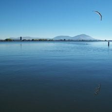
Gerber Reservoir is a large water body in south central Oregon covering nearly 4000 acres at full capacity. The lake is used for irrigation storage, causing the water level to change substantially throughout the year based on rainfall and water demands.

The reservoir was built as an irrigation project to support agriculture in southern Oregon and has developed into a recreational destination over the decades. Today it serves both its original purpose of water storage and functions as a fishing and outdoor recreation area.

The reservoir is easiest to reach from Klamath Falls by driving east through Bonanza, a trip of less than one hour. Boat ramps are located on the north end near the Ben Hall arm and at the southeast end, but bring a map or directions since roads from Lakeview are less direct.

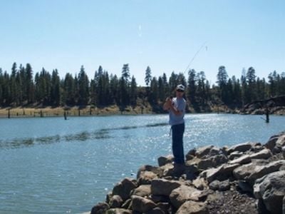
The lake is known among anglers for large crappie exceeding 4 pounds and yellow perch reaching up to 14 inches, which gather in the arms where tributaries flow in during late spring and early summer. The fish move to deeper water during hot daytime hours, making early morning and evening the prime fishing times.

The community of curious travelers

AroundUs brings together thousands of curated places, local tips, and hidden gems, enriched daily by 60,000 contributors worldwide.

Start exploring
Location
GPS coordinates
42.19904,-121.10204
Latest update
February 9, 2026 08:21
Around this place
Lava Beds National Monument
United States of America

Lava Beds National Monument

63.6 km
Captain Jack's Stronghold
United States of America

Captain Jack's Stronghold

53.6 km
Lower Klamath National Wildlife Refuge
United States of America

Lower Klamath National Wildlife Refuge

56.5 km
Link River Dam
United States of America

Link River Dam

57.8 km
Tule Lake National Wildlife Refuge
United States of America

Tule Lake National Wildlife Refuge

47.3 km
OC&E Woods Line State Trail
United States of America

OC&E Woods Line State Trail

53.6 km
Clear Lake National Wildlife Refuge
United States of America

Clear Lake National Wildlife Refuge

37.7 km
Gearhart Mountain Wilderness
United States of America

Gearhart Mountain Wilderness

40.1 km
Lake Ewauna
United States of America

Lake Ewauna

55.8 km
Petroglyph Point Archaeological Site
United States of America

Petroglyph Point Archaeological Site

46.1 km
Schonchin Butte
United States of America

Schonchin Butte

62.3 km
Hunter's Hot Springs
United States of America

Hunter's Hot Springs

60.5 km
Klamath Basin National Wildlife Refuge Complex
United States of America

Klamath Basin National Wildlife Refuge Complex

47.5 km
Canby's Cross
United States of America

Canby's Cross

55.9 km
Booth State Scenic Corridor
United States of America

Booth State Scenic Corridor

42.9 km
Goose Lake meteorite
United States of America

Goose Lake meteorite

52.3 km
Bly Ranger Station
United States of America

Bly Ranger Station

22.9 km
Klamath Falls City Hall
United States of America

Klamath Falls City Hall

56 km
Lake County Round Sale Barn
United States of America

Lake County Round Sale Barn

61.1 km
Judge Henry L. Benson House
United States of America

Judge Henry L. Benson House

56.4 km
John N. and Cornelia Watson House
United States of America

John N. and Cornelia Watson House

62.1 km
Richardson–Ulrich House
United States of America

Richardson–Ulrich House

57 km
Tule Lake National Monument
United States of America

Tule Lake National Monument

41.2 km
Klamath County Museum
United States of America

Klamath County Museum

55.6 km
Skull Cave
United States of America

Skull Cave

62.1 km
Hospital Rock Trail
United States of America

Hospital Rock Trail

50.8 km
Ross Ragland Theatre
United States of America

Ross Ragland Theatre

56.2 km
Star Theater
United States of America

Star Theater

22.8 km
Show the full map
« Gerber Reservoir - reservoir in Oregon, USA » is provided by Around Us (aroundus.com). Images and texts are derived from Wikimedia project under a Creative Commons license. You are allowed to copy, distribute, and modify copies of this page, under the conditions set by the license, as long as this note is clearly visible.

Discover hidden gems everywhere you go!

From secret cafés to breathtaking viewpoints, skip the crowded tourist spots and find places that match your style. Our app makes it easy with voice search, smart filtering, route optimization, and insider tips from travelers worldwide. Download now for the complete mobile experience.

Around Us App Screenshot

A unique approach to discovering new places

Le Figaro

All the places worth exploring

France Info

A tailor-made excursion in just a few clicks

20 Minutes

Around Us
Travel Guide & Maps
Download

Send to your phone

QR Code
1

Open the camera app on your mobile.

2

Point at the QR code with your camera. A notification will appear.

3

Tap the notification to open the link.