Booth State Scenic Corridor

Log in to your account

AroundUs is a community-driven map of interesting places, built by curious explorers like you. It grows with every review, story, and photo you share.
Connect to save your favorite spots, contribute locations, and create personalized routes.
Continue with Google
Continue with Apple
Continue with X
Continue with Facebook
Continue with email
By continuing, you accept our Terms and Conditions and our Privacy Policy
Create an account

Booth State Scenic Corridor

Add to collection
Map
Suggest a change
Share

Booth State Scenic Corridor, State park in Lake County, Oregon, United States.

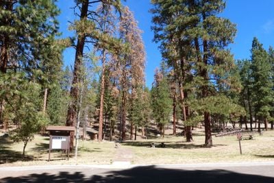
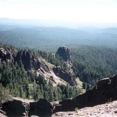
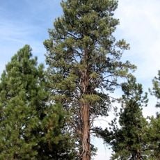
Booth State Scenic Corridor is a 318-acre area covered with dense conifer forests of ponderosa pine and western juniper along Oregon Route 140 west of Lakeview. The park offers picnic tables, vault toilets, and parking spaces for day visitors exploring the wooded landscape.

Robert A. Booth, president of Oregon Land and Live Stock Company, donated the initial 50 acres in 1928 to establish this corridor. During the 1930s, the Civilian Conservation Corps expanded the infrastructure and added more facilities to the original land contribution.

The Civilian Conservation Corps shaped the place during the 1930s by building picnic areas and gathering spots. These developments changed how people in the region spend time outdoors and enjoy nature together.

The place is easily accessible along Oregon Route 140 with free parking available during the day. It is wise to check what facilities are available before your visit, as access and amenities may vary by season.

The forest is home to mule deer, coyotes, and cougars that visitors may glimpse while exploring attentively. In fall, quaking aspen trees turn brilliant yellow and red, transforming the whole corridor with changing colors throughout the season.

Location: Oregon

Inception: 1928

Website: https://stateparks.oregon.gov/index.cfm?do=park.profile&parkId=37

GPS coordinates: 42.18880,-120.58200

Latest update: December 14, 2025 09:41

Photos
Around this place
Paisley Caves
United States of America

Paisley Caves

63.8 km
Summer Lake Hot Springs
United States of America

Summer Lake Hot Springs

60 km
Hart Mountain National Antelope Refuge
United States of America

Hart Mountain National Antelope Refuge

86.1 km
Tule Lake National Wildlife Refuge
United States of America

Tule Lake National Wildlife Refuge

82.4 km
Clear Lake National Wildlife Refuge
United States of America

Clear Lake National Wildlife Refuge

57 km
Modoc National Wildlife Refuge
United States of America

Modoc National Wildlife Refuge

81.7 km
Gearhart Mountain Wilderness
United States of America

Gearhart Mountain Wilderness

42.8 km
Abert Rim
United States of America

Abert Rim

36.2 km
Greaser Petroglyph Site
United States of America

Greaser Petroglyph Site

63.9 km
Camp Warner
United States of America

Camp Warner

75.2 km
Petroglyph Point Archaeological Site
United States of America

Petroglyph Point Archaeological Site

77.1 km
Goose Lake State Recreation Area
United States of America

Goose Lake State Recreation Area

30.4 km
Chandler State Wayside
United States of America

Chandler State Wayside

34.2 km
Hunter's Hot Springs
United States of America

Hunter's Hot Springs

17.9 km
Klamath Basin National Wildlife Refuge Complex
United States of America

Klamath Basin National Wildlife Refuge Complex

85.6 km
Stone Bridge and the Oregon Central Military Wagon Road
United States of America

Stone Bridge and the Oregon Central Military Wagon Road

63.9 km
Gerber Reservoir
United States of America

Gerber Reservoir

42.9 km
Goose Lake meteorite
United States of America

Goose Lake meteorite

23.5 km
Deep Creek Falls
United States of America

Deep Creek Falls

52.2 km
Bly Ranger Station
United States of America

Bly Ranger Station

44.9 km
Lake County Round Sale Barn
United States of America

Lake County Round Sale Barn

18.2 km
John N. and Cornelia Watson House
United States of America

John N. and Cornelia Watson House

19.3 km
William P. Heryford House
United States of America

William P. Heryford House

19.5 km
Tule Lake National Monument
United States of America

Tule Lake National Monument

73.5 km
Hospital Rock Trail
United States of America

Hospital Rock Trail

83.4 km
Alger Theatre
United States of America

Alger Theatre

19.4 km
Niles Theater
United States of America

Niles Theater

78.6 km
Star Theater
United States of America

Star Theater

44.7 km
Show the full map
Reviews

Visited this place? Tap the stars to rate it and share your experience / photos with the community! Try now! You can cancel it anytime.

« Booth State Scenic Corridor - State park in Lake County, Oregon, United States » is provided by Around Us (aroundus.com). Images and texts are derived from Wikimedia project under a Creative Commons license. You are allowed to copy, distribute, and modify copies of this page, under the conditions set by the license, as long as this note is clearly visible.

Discover hidden gems everywhere you go!

From secret cafés to breathtaking viewpoints, skip the crowded tourist spots and find places that match your style. Our app makes it easy with voice search, smart filtering, route optimization, and insider tips from travelers worldwide. Download now for the complete mobile experience.

Around Us App Screenshot

A unique approach to discovering new places

Le Figaro

All the places worth exploring

France Info

A tailor-made excursion in just a few clicks

20 Minutes