Enable Location

We need your location to show you interesting places around you

Discover nearby places

Find interesting locations and hidden gems around you

Precise directions

Get accurate directions and distances to places

Your location is never shared with other users. It's only used when you tap the location button.

Camp Warner

Log in to your account

Start exploring — it's free

Trusted by 63,029 travelers worldwide

Continue with Google
Continue with Apple
or

We will send you a code to connect

By continuing, you accept our Terms and Conditions and our Privacy Policy

Check your inbox

We've sent a pincode in your inbox. Please enter the code below.

Camp Warner
Discussion Reviews 1 Photos
2.6k Popularity

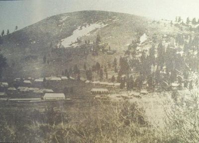
Camp Warner, Military outpost in Eastern Oregon, United States.

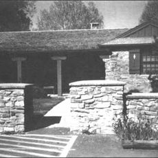
Camp Warner was a military outpost at two locations near the Warner Lakes, featuring barracks, officer housing, workshops, and support structures. The remains today include a stone bridge spanning roughly a quarter mile (400 meters) between Hart Lake and Crump Lake, which is registered as a historical landmark.

The US Army established Camp Warner in 1866 as a protective post during the period of western expansion and armed conflicts with Native American tribes. The post was abandoned after less than two decades as military priorities shifted and the region changed.

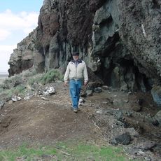
The site reflects encounters between military personnel, settlers, and Native American communities that shaped the region. Visitors can sense this intersection of cultures through the layout and ruins of the former compound.

The site sits at high elevation in a region with harsh weather and requires sturdy footwear and appropriate clothing for any season. Visitors should plan for limited facilities and bring plenty of water and supplies, as the location remains quite remote.

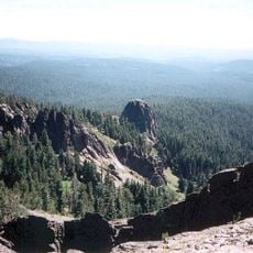
Soldiers stationed at this 1,880 meter (6,171 foot) elevation endured such extreme winter conditions that they marched continuously around the parade ground to maintain body heat. This unusual survival tactic reveals how harsh life was at this remote outpost.

The community of curious travelers

AroundUs brings together thousands of curated places, local tips, and hidden gems, enriched daily by 60,000 contributors worldwide.

Start exploring
Location
Inception
1866
GPS coordinates
42.43025,-119.72926
Latest update
December 12, 2025 17:47
Around this place
Paisley Caves
United States of America

Paisley Caves

76.8 km
Summer Lake Hot Springs
United States of America

Summer Lake Hot Springs

82.1 km
Sheldon National Wildlife Refuge
United States of America

Sheldon National Wildlife Refuge

79.2 km
Hart Mountain National Antelope Refuge
United States of America

Hart Mountain National Antelope Refuge

14.6 km
Steens Mountain Wilderness
United States of America

Steens Mountain Wilderness

84.4 km
Summer Lake Wildlife Area
United States of America

Summer Lake Wildlife Area

102.6 km
Gearhart Mountain Wilderness
United States of America

Gearhart Mountain Wilderness

93.5 km
Abert Rim
United States of America

Abert Rim

41.8 km
David L. Shirk Ranch
United States of America

David L. Shirk Ranch

27.4 km
Frenchglen Hotel State Heritage Site
United States of America

Frenchglen Hotel State Heritage Site

80 km
Greaser Petroglyph Site
United States of America

Greaser Petroglyph Site

28.3 km
P Ranch
United States of America

P Ranch

81.9 km
Goose Lake State Recreation Area
United States of America

Goose Lake State Recreation Area

68.9 km
Chandler State Wayside
United States of America

Chandler State Wayside

46.2 km
Hunter's Hot Springs
United States of America

Hunter's Hot Springs

57.6 km
Stone Bridge and the Oregon Central Military Wagon Road
United States of America

Stone Bridge and the Oregon Central Military Wagon Road

12.3 km
Booth State Scenic Corridor
United States of America

Booth State Scenic Corridor

75.2 km
Double-O Ranch Historic District
United States of America

Double-O Ranch Historic District

100.3 km
Goose Lake meteorite
United States of America

Goose Lake meteorite

83.7 km
Deep Creek Falls
United States of America

Deep Creek Falls

33.8 km
Bly Ranger Station
United States of America

Bly Ranger Station

108.3 km
Lake County Round Sale Barn
United States of America

Lake County Round Sale Barn

58.2 km
John N. and Cornelia Watson House
United States of America

John N. and Cornelia Watson House

57.6 km
William P. Heryford House
United States of America

William P. Heryford House

57.5 km
Alger Theatre
United States of America

Alger Theatre

57.5 km
Star Theater
United States of America

Star Theater

108.1 km
BLM Field Camp
United States of America

BLM Field Camp

49 km
BLM Field Camp
United States of America

BLM Field Camp

30.1 km
Show the full map
Reviews
Share your experience

No review yet

Discussions
Start a discussion...

No discussion yet

« Camp Warner - Military outpost in Eastern Oregon, United States » is provided by Around Us (aroundus.com). Images and texts are derived from Wikimedia project under a Creative Commons license. You are allowed to copy, distribute, and modify copies of this page, under the conditions set by the license, as long as this note is clearly visible.

Discover hidden gems everywhere you go!

From secret cafés to breathtaking viewpoints, skip the crowded tourist spots and find places that match your style. Our app makes it easy with voice search, smart filtering, route optimization, and insider tips from travelers worldwide. Download now for the complete mobile experience.

Around Us App Screenshot

A unique approach to discovering new places

Le Figaro

All the places worth exploring

France Info

A tailor-made excursion in just a few clicks

20 Minutes

Around Us
Travel Guide & Maps
Download

Send to your phone

QR Code
1

Open the camera app on your mobile.

2

Point at the QR code with your camera. A notification will appear.

3

Tap the notification to open the link.