Enable Location

We need your location to show you interesting places around you

Discover nearby places

Find interesting locations and hidden gems around you

Precise directions

Get accurate directions and distances to places

Your location is never shared with other users. It's only used when you tap the location button.

David L. Shirk Ranch

Log in to your account

Start exploring — it's free

Trusted by 62,370 travelers worldwide

Continue with Google
Continue with Apple
or

We will send you a code to connect

By continuing, you accept our Terms and Conditions and our Privacy Policy

Check your inbox

We've sent a pincode in your inbox. Please enter the code below.

David L. Shirk Ranch, Historic ranch district in Guano Valley, Oregon

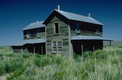
David L. Shirk Ranch is a historic property with nineteen wooden buildings spread across 14.5 acres in Guano Valley. The main structures include a house, worker housing, a barn, and a water tower that served the daily needs of ranch operations.

The property was established in 1881 and purchased by David L. Shirk in 1883 to operate as a horse breeding facility. It supplied military forces with animals until 1914, when ranch operations ceased.

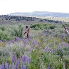
The buildings show how settlers in the high desert region organized their daily work and family life in the late 1800s. You can see from the construction how people adapted to living far from towns and supply sources.

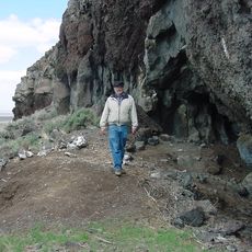
The property is maintained by the Bureau of Land Management and open to visitors who want to explore the historic structures on the grounds. Access is easiest during warmer months when roads to the remote location are in better condition.

The main house contains a second-floor billiard room where ranch workers and family gathered during winter evenings for entertainment and social time. This detail reveals how people created leisure activities even in remote, isolated locations.

The community of curious travelers

AroundUs brings together thousands of curated places, local tips, and hidden gems, enriched daily by 60,000 contributors worldwide.

Start exploring
Location
GPS coordinates
42.23850,-119.52000
Latest update
December 12, 2025 09:05
Around this place
Paisley Caves
United States of America

Paisley Caves

102.7 km
Summer Lake Hot Springs
United States of America

Summer Lake Hot Springs

107.3 km
Sheldon National Wildlife Refuge
United States of America

Sheldon National Wildlife Refuge

52.4 km
Hart Mountain National Antelope Refuge
United States of America

Hart Mountain National Antelope Refuge

36.4 km
Steens Mountain Wilderness
United States of America

Steens Mountain Wilderness

79.1 km
Mickey Hot Springs
United States of America

Mickey Hot Springs

108 km
Abert Rim
United States of America

Abert Rim

61.1 km
Frenchglen Hotel State Heritage Site
United States of America

Frenchglen Hotel State Heritage Site

82.2 km
Greaser Petroglyph Site
United States of America

Greaser Petroglyph Site

24.5 km
P Ranch
United States of America

P Ranch

83.6 km
Camp Warner
United States of America

Camp Warner

27.4 km
Goose Lake State Recreation Area
United States of America

Goose Lake State Recreation Area

71.7 km
United States of America

Little High Rock Canyon Wilderness

110.4 km
Chandler State Wayside
United States of America

Chandler State Wayside

66.1 km
High Rock Canyon Wilderness
United States of America

High Rock Canyon Wilderness

95.1 km
United States of America

North Black Rock Range Wilderness

97.7 km
Hunter's Hot Springs
United States of America

Hunter's Hot Springs

70 km
Stone Bridge and the Oregon Central Military Wagon Road
United States of America

Stone Bridge and the Oregon Central Military Wagon Road

29.3 km
United States of America

East Fork High Rock Canyon Wilderness

90.8 km
Booth State Scenic Corridor
United States of America

Booth State Scenic Corridor

87.7 km
Goose Lake meteorite
United States of America

Goose Lake meteorite

89.2 km
Deep Creek Falls
United States of America

Deep Creek Falls

36.2 km
Lake County Round Sale Barn
United States of America

Lake County Round Sale Barn

69.5 km
John N. and Cornelia Watson House
United States of America

John N. and Cornelia Watson House

68.5 km
William P. Heryford House
United States of America

William P. Heryford House

68.3 km
Alger Theatre
United States of America

Alger Theatre

68.3 km
BLM Field Camp
United States of America

BLM Field Camp

23.1 km
BLM Field Camp
United States of America

BLM Field Camp

24.6 km
Show the full map
« David L. Shirk Ranch - Historic ranch district in Guano Valley, Oregon » is provided by Around Us (aroundus.com). Images and texts are derived from Wikimedia project under a Creative Commons license. You are allowed to copy, distribute, and modify copies of this page, under the conditions set by the license, as long as this note is clearly visible.

Discover hidden gems everywhere you go!

From secret cafés to breathtaking viewpoints, skip the crowded tourist spots and find places that match your style. Our app makes it easy with voice search, smart filtering, route optimization, and insider tips from travelers worldwide. Download now for the complete mobile experience.

Around Us App Screenshot

A unique approach to discovering new places

Le Figaro

All the places worth exploring

France Info

A tailor-made excursion in just a few clicks

20 Minutes

Around Us
Travel Guide & Maps
Download

Send to your phone

QR Code
1

Open the camera app on your mobile.

2

Point at the QR code with your camera. A notification will appear.

3

Tap the notification to open the link.