Enable Location

We need your location to show you interesting places around you

Discover nearby places

Find interesting locations and hidden gems around you

Precise directions

Get accurate directions and distances to places

Your location is never shared with other users. It's only used when you tap the location button.

Winslow

Log in to your account

Start exploring — it's free

Trusted by 61,916 travelers worldwide

Continue with Google
Continue with Apple
or

We will send you a code to connect

By continuing, you accept our Terms and Conditions and our Privacy Policy

Check your inbox

We've sent a pincode in your inbox. Please enter the code below.

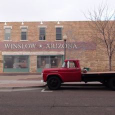
Winslow, Railroad city in Arizona, US

Winslow sits where Interstate 40 meets Arizona State Route 87 in Navajo County, resting at an elevation of 4,850 feet (1,478 meters) across flat desert land. The town extends along old railway lines that still run through the center, shaping the layout of streets and buildings.

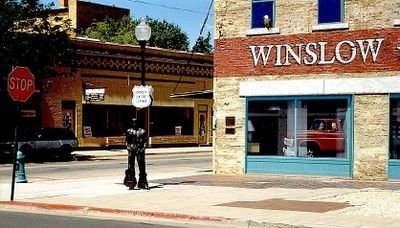
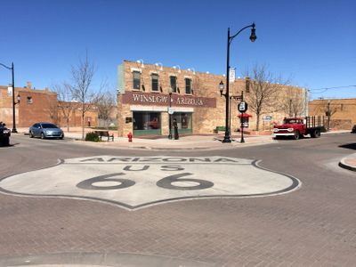
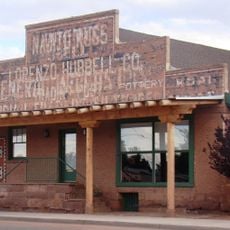
The Atlantic and Pacific Railroad established a station here in 1882, which quickly grew into a key stop for steam locomotives needing water and fuel. Route 66 and later Interstate 40 brought new waves of travelers through the area during the 20th century.

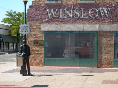
The Standin' on the Corner Park features a bronze statue and murals commemorating the Eagles song Take It Easy, which references the city in its lyrics.

The Winslow-Lindbergh Regional Airport and the Amtrak Southwest Chief train service offer arrival options for visitors coming from different directions. Interstate 40 connects the town west to Flagstaff and east to Albuquerque.

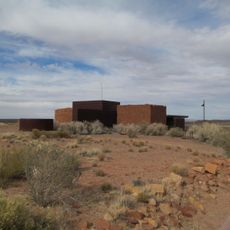
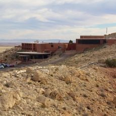
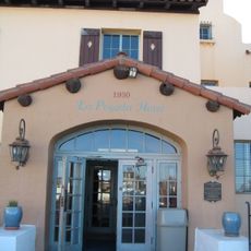
The La Posada Hotel was designed by architect Mary Colter in 1930 and became the final railroad hotel built by the Fred Harvey Company along the Santa Fe Railway. The building fell into disrepair for decades but was carefully restored in the 1990s and now operates again.

The community of curious travelers

AroundUs brings together thousands of curated places, local tips, and hidden gems, enriched daily by 60,000 contributors worldwide.

Start exploring
Location
Inception
1900
Elevation above the sea
1,478 m
GPS coordinates
35.02861,-110.70083
Latest update
December 12, 2025 23:22
Around this place
Meteor Crater
United States of America

Meteor Crater

29.4 km
Standin' on the Corner Park
United States of America

Standin' on the Corner Park

625 m
Canyon Diablo meteorite
United States of America

Canyon Diablo meteorite

30.4 km
Chevelon Creek Bridge
United States of America

Chevelon Creek Bridge

19.6 km
Meteor Crater Natural Landmark
United States of America

Meteor Crater Natural Landmark

29.3 km
Homolovi State Park
United States of America

Homolovi State Park

6.6 km
Meteor Crater Visitor Center
United States of America

Meteor Crater Visitor Center

29.2 km
Meteor City, Arizona
United States of America

Meteor City, Arizona

22.6 km
La Posada Historic District
United States of America

La Posada Historic District

953 m
Brigham City
United States of America

Brigham City

2.2 km
United States of America

Clear Creek Reservoir

8.2 km
Lorenzo Hubbell Trading Post and Warehouse
United States of America

Lorenzo Hubbell Trading Post and Warehouse

448 m
American Astronaut Wall of Fame
United States of America

American Astronaut Wall of Fame

29.2 km
United States of America

Relic Point

23.3 km
Old Jack's Canyon Bridge
United States of America

Old Jack's Canyon Bridge

7.3 km
United States of America

Work of art, sculpture

562 m
United States of America

Rock Art Ranch

28 km
United States of America

Jackrabbit

25.5 km
United States of America

Astronaut Statue

29.4 km
United States of America

Little Painted Desert Country Park

26.8 km
United States of America

Scenic viewpoint

29.2 km
United States of America

Scenic viewpoint

29.8 km
United States of America

Scenic viewpoint

29.5 km
United States of America

Scenic viewpoint

6.8 km
United States of America

Scenic viewpoint

5.3 km
United States of America

Scenic viewpoint

3.6 km
United States of America

Scenic viewpoint

29.2 km
United States of America

Scenic viewpoint

29.1 km
Show the full map
« Winslow - Railroad city in Arizona, US » is provided by Around Us (aroundus.com). Images and texts are derived from Wikimedia project under a Creative Commons license. You are allowed to copy, distribute, and modify copies of this page, under the conditions set by the license, as long as this note is clearly visible.

Discover hidden gems everywhere you go!

From secret cafés to breathtaking viewpoints, skip the crowded tourist spots and find places that match your style. Our app makes it easy with voice search, smart filtering, route optimization, and insider tips from travelers worldwide. Download now for the complete mobile experience.

Around Us App Screenshot

A unique approach to discovering new places

Le Figaro

All the places worth exploring

France Info

A tailor-made excursion in just a few clicks

20 Minutes

Around Us
Travel Guide & Maps
Download

Send to your phone

QR Code
1

Open the camera app on your mobile.

2

Point at the QR code with your camera. A notification will appear.

3

Tap the notification to open the link.