Chest opened
+${chestReward.xp} XP
Explorer
NOUVEAU ×${chestReward.collectible.quantity}
tapez pour fermer
Chest locked

Open chests in the app

Around Us is built for your phone — chests unlock when you walk, explore and capture nearby places.

Enable Location

We need your location to show you interesting places around you

Discover nearby places

Find interesting locations and hidden gems around you

Precise directions

Get accurate directions and distances to places

Your location is never shared with other users. It's only used when you tap the location button.

Log in to your account

Start exploring — it's free

Trusted by 73,021 travelers worldwide

Continue with Google
Continue with Apple
or

We will send you a code to connect

By continuing, you accept our Terms and Conditions and our Privacy Policy

Check your inbox

We've sent a pincode in your inbox. Please enter the code below.

Chama River Canyon Wilderness
Discussion Reviews Photo
3.3k Popularity

Chama River Canyon Wilderness, U.S. Wilderness Area in New Mexico.

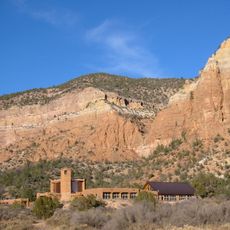
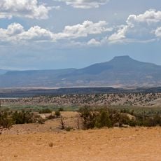
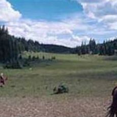
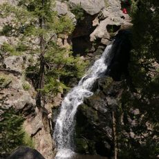
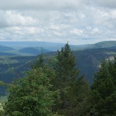
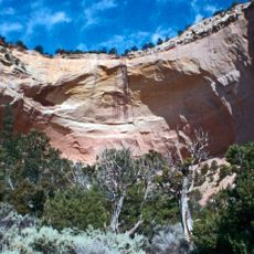
Chama River Canyon Wilderness is a protected area in northwestern New Mexico with tall sandstone cliffs rising above the river and forested slopes covered in ponderosa pines. The Rio Chama flows through multi-colored canyon sections, creating natural corridors bordered by dense forest vegetation along the terrain.

Congress established this wilderness area in 1978 through the Endangered American Wilderness Act to safeguard natural resources and ecological diversity. This legislation was part of a broader effort to protect significant wild places across the nation.

The Continental Divide Trail passes through this wilderness, offering hikers a way to connect with a broader network of mountain pathways and experience the landscape that communities have valued for generations.

Access requires permits and uses a lottery system for launch dates to maintain environmental protection. Visitors should plan ahead and prepare for a remote location with limited facilities or support services.

Black bears, mountain lions, and elk roam freely through the multi-colored canyons, using this space as their natural habitat without barriers. These large animals are rarely spotted by visitors but shape the ecosystem and demonstrate the remote nature of the place.

The community of curious travelers

AroundUs brings together thousands of curated places, local tips, and hidden gems, enriched daily by 60,000 contributors worldwide.

Start exploring
Location
GPS coordinates
36.33490,-106.66100
Latest update
December 12, 2025 09:01
Around this place
Los Alamos National Laboratory
United States of America

Los Alamos National Laboratory

59.4 km
Valles Caldera
United States of America

Valles Caldera

52.8 km
Ghost Ranch
United States of America

Ghost Ranch

16.8 km
Puye Cliff Dwellings
United States of America

Puye Cliff Dwellings

55.8 km
Georgia O'Keeffe Home and Studio
United States of America

Georgia O'Keeffe Home and Studio

34 km
Monastery of Christ in the Desert
United States of America

Monastery of Christ in the Desert

5.1 km
Cerro Pedernal
United States of America

Cerro Pedernal

23.8 km
Bradbury Science Museum
United States of America

Bradbury Science Museum

60.1 km
Ojo Caliente Mineral Springs Resort & Spa
United States of America

Ojo Caliente Mineral Springs Resort & Spa

55.2 km
Chicoma Mountain
United States of America

Chicoma Mountain

44.1 km
Fenton Lake State Park
United States of America

Fenton Lake State Park

50.7 km
San Pedro Parks Wilderness
United States of America

San Pedro Parks Wilderness

30.1 km
United States of America

Redondo Peak

52.3 km
San Gabriel de Yungue-Ouinge
United States of America

San Gabriel de Yungue-Ouinge

60.4 km
Abiquiu Dam
United States of America

Abiquiu Dam

23.7 km
Jemez Falls
United States of America

Jemez Falls

58.7 km
Ojo Caliente Hot Springs Round Barn
United States of America

Ojo Caliente Hot Springs Round Barn

55.1 km
Los Alamos Historical Museum
United States of America

Los Alamos Historical Museum

59.8 km
Mesa Public Library
United States of America

Mesa Public Library

59.7 km
Posi-ouinge
United States of America

Posi-ouinge

54.8 km
Cerro Grande
United States of America

Cerro Grande

56.4 km
Tsama Pueblo
United States of America

Tsama Pueblo

42.9 km
Fort Lowell
United States of America

Fort Lowell

44 km
Samuel Sanchez House
United States of America

Samuel Sanchez House

48.9 km
Rio Grande Bridge at San Juan Pueblo
United States of America

Rio Grande Bridge at San Juan Pueblo

60.5 km
Gilbert Martinez Barn
United States of America

Gilbert Martinez Barn

43.6 km
Sanchez-March House
United States of America

Sanchez-March House

45.8 km
Echo amphitheatre
United States of America

Echo amphitheatre

12.2 km
Show the full map
Reviews
Share your experience

No review yet

Discussions
Start a discussion...

No discussion yet

« Chama River Canyon Wilderness - U.S. Wilderness Area in New Mexico » is provided by Around Us (aroundus.com). Images and texts are derived from Wikimedia project under a Creative Commons license. You are allowed to copy, distribute, and modify copies of this page, under the conditions set by the license, as long as this note is clearly visible.

Discover hidden gems everywhere you go!

From secret cafés to breathtaking viewpoints, skip the crowded tourist spots and find places that match your style. Our app makes it easy with voice search, smart filtering, route optimization, and insider tips from travelers worldwide. Download now for the complete mobile experience.

Around Us App Screenshot

A unique approach to discovering new places

Le Figaro

All the places worth exploring

France Info

A tailor-made excursion in just a few clicks

20 Minutes

Around Us
Travel Guide & Maps
Download

Send to your phone

QR Code
1

Open the camera app on your mobile.

2

Point at the QR code with your camera. A notification will appear.

3

Tap the notification to open the link.