Enable Location

We need your location to show you interesting places around you

Discover nearby places

Find interesting locations and hidden gems around you

Precise directions

Get accurate directions and distances to places

Your location is never shared with other users. It's only used when you tap the location button.

Crystal Mill

Log in to your account

Start exploring — it's free

Trusted by 63,015 travelers worldwide

Continue with Google
Continue with Apple
or

We will send you a code to connect

By continuing, you accept our Terms and Conditions and our Privacy Policy

Check your inbox

We've sent a pincode in your inbox. Please enter the code below.

Discussion Reviews 1 Photos 1 Collections
33k Popularity

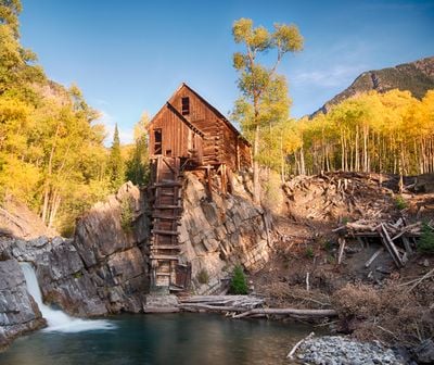
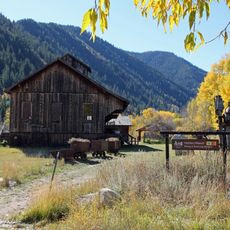
Crystal Mill, Historic power station in Crystal, Colorado.

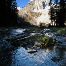
Crystal Mill is a wooden power station perched on a rocky ledge above the Crystal River in the mountains near Marble, Colorado. Water flows directly beneath the structure, and the surrounding landscape consists of pine forests and steep mountain slopes.

George C. Eaton and B.S. Phillips built the facility in 1893 to supply compressed air for drilling equipment at Sheep Mountain silver mines. Operations ceased in 1917 when mining activity declined and the area's mines closed down.

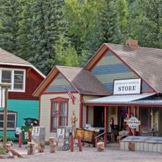
Photographers travel here throughout the year to capture the building balanced on its rocky perch above the rushing water below. The location draws hikers and off-road enthusiasts who appreciate the remote mountain setting and the way the wooden frame contrasts with the surrounding wilderness.

Reaching the site from Marble requires a four-wheel drive vehicle because the route consists of unpaved roads with difficult sections. Summer months offer the best access conditions, while winter typically brings snow and ice that make the road impassable.

The facility relied on a horizontal waterwheel that drove air compressors to power pneumatic tools in nearby silver mines. This engineering approach was uncommon at the time, as most mines used steam power directly on site.

The community of curious travelers

AroundUs brings together thousands of curated places, local tips, and hidden gems, enriched daily by 60,000 contributors worldwide.

Start exploring
Location
Inception
1893
GPS coordinates
39.05889,-107.10389
Latest update
December 19, 2025 23:57
Colorado natural treasures and remote locations

Colorado contains natural areas and historical sites located away from main roads and common routes. These places tell the story of the state's geology and human history through varied landscapes. Visitors will find sand dunes, waterfalls, rock formations, and remains from the mining era. Locations...

Around this place
Maroon Bells
United States of America

Maroon Bells

10 km
Capitol Peak
United States of America

Capitol Peak

10.3 km
Castle Peak
United States of America

Castle Peak

21.7 km
Pyramid Peak
United States of America

Pyramid Peak

13.4 km
Redstone Coke Oven Historic District
United States of America

Redstone Coke Oven Historic District

18.1 km
Redstone Castle
United States of America

Redstone Castle

17.1 km
Maroon Bells–Snowmass Wilderness
United States of America

Maroon Bells–Snowmass Wilderness

9.4 km
McClure Pass
United States of America

McClure Pass

17.4 km
Wheeler Opera House
United States of America

Wheeler Opera House

28.5 km
Redstone Historic District
United States of America

Redstone Historic District

17.9 km
Snowmass Peak
United States of America

Snowmass Peak

7.1 km
Pioneer Park
United States of America

Pioneer Park

28.2 km
United States of America

Cathedral Peak

21.4 km
Maroon Creek Bridge
United States of America

Maroon Creek Bridge

27.1 km
Wheeler–Stallard House
United States of America

Wheeler–Stallard House

28.1 km
D.E. Frantz House
United States of America

D.E. Frantz House

28.2 km
Davis Waite House
United States of America

Davis Waite House

28.5 km
Holden/Marolt Mining and Ranching Museum
United States of America

Holden/Marolt Mining and Ranching Museum

27.6 km
Marble Community Church
United States of America

Marble Community Church

7.5 km
Matthew Callahan Log Cabin
United States of America

Matthew Callahan Log Cabin

28.1 km
Osgood Gamekeeper's Lodge
United States of America

Osgood Gamekeeper's Lodge

17.4 km
Marble High School
United States of America

Marble High School

7.8 km
Bowles–Cooley House
United States of America

Bowles–Cooley House

28.5 km
Samuel I. Hallett House
United States of America

Samuel I. Hallett House

28.3 km
Smith–Elisha House
United States of America

Smith–Elisha House

28.2 km
Osgood–Kuhnhausen House
United States of America

Osgood–Kuhnhausen House

18.2 km
Dixon–Markle House
United States of America

Dixon–Markle House

28.3 km
Mount Sopris
United States of America

Mount Sopris

23.1 km
Show the full map
Reviews
Share your experience

No review yet

Discussions
Start a discussion...

No discussion yet

« Crystal Mill - Historic power station in Crystal, Colorado » is provided by Around Us (aroundus.com). Images and texts are derived from Wikimedia project under a Creative Commons license. You are allowed to copy, distribute, and modify copies of this page, under the conditions set by the license, as long as this note is clearly visible.

Discover hidden gems everywhere you go!

From secret cafés to breathtaking viewpoints, skip the crowded tourist spots and find places that match your style. Our app makes it easy with voice search, smart filtering, route optimization, and insider tips from travelers worldwide. Download now for the complete mobile experience.

Around Us App Screenshot

A unique approach to discovering new places

Le Figaro

All the places worth exploring

France Info

A tailor-made excursion in just a few clicks

20 Minutes

Around Us
Travel Guide & Maps
Download

Send to your phone

QR Code
1

Open the camera app on your mobile.

2

Point at the QR code with your camera. A notification will appear.

3

Tap the notification to open the link.