Enable Location

We need your location to show you interesting places around you

Discover nearby places

Find interesting locations and hidden gems around you

Precise directions

Get accurate directions and distances to places

Your location is never shared with other users. It's only used when you tap the location button.

Little Goose Dam

Log in to your account

Start exploring — it's free

Trusted by 65,516 travelers worldwide

Continue with Google
Continue with Apple
or

We will send you a code to connect

By continuing, you accept our Terms and Conditions and our Privacy Policy

Check your inbox

We've sent a pincode in your inbox. Please enter the code below.

Discussion Reviews 1 Photos
4k Popularity

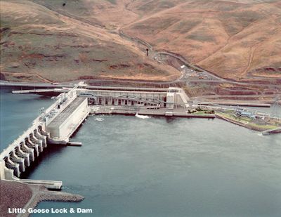
Little Goose Dam, Hydroelectric dam on Snake River in Whitman County and Columbia County, United States.

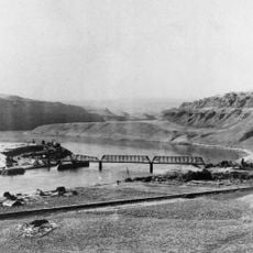
Little Goose Dam is a concrete dam on the Snake River that combines a hydroelectric power station with a navigation lock, straddling the boundary between Whitman County and Columbia County in Washington State. The dam backs up the river to form Lake Bryan, a long reservoir that stretches upstream and is visible from the roads running along the bank.

Construction started in 1963 under the US Army Corps of Engineers, and the dam went into operation in 1970 with three generating units. It was one of several dams built along the Snake River as part of a federal program to open the river to barge traffic and generate power.

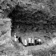
The dam sits in a region where Indigenous tribes fished for salmon for generations, and the river here still draws people who come to fish from the shoreline. The area around Lake Bryan is used today for boating and recreational fishing, giving the site a quiet working-river feel.

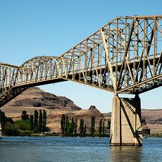
Several viewpoints along the shore of Lake Bryan give a clear view of the dam and are accessible for most of the year, though winter conditions can make the roads slippery. Visiting in spring or fall tends to give the best experience and a good chance of seeing barges moving through the lock.

The dam is regularly discussed as a candidate for removal to help restore salmon migration along the Snake River, making it one of the few active dams in the country where dismantling is a live debate. The question has drawn attention from tribes, fishing communities, and environmental groups for decades.

The community of curious travelers

AroundUs brings together thousands of curated places, local tips, and hidden gems, enriched daily by 60,000 contributors worldwide.

Start exploring
Location
Location
Inception
1963
Length
809 m
GPS coordinates
46.58750,-118.02611
Latest update
March 3, 2026 10:05
Around this place
Palouse Falls
United States of America

Palouse Falls

17.3 km
Marmes Rockshelter
United States of America

Marmes Rockshelter

13.8 km
Palouse Falls State Park
United States of America

Palouse Falls State Park

17.5 km
Lower Granite Dam
United States of America

Lower Granite Dam

46.4 km
Columbia Plateau State Park Trail
United States of America

Columbia Plateau State Park Trail

40.9 km
Lower Monumental Dam
United States of America

Lower Monumental Dam

39.2 km
Snake River Bridge
United States of America

Snake River Bridge

14.8 km
Borleske Stadium
United States of America

Borleske Stadium

61.6 km
Manning-Rye Covered Bridge
United States of America

Manning-Rye Covered Bridge

60.1 km
Joso High Bridge
United States of America

Joso High Bridge

15.5 km
Kirkman House
United States of America

Kirkman House

62.4 km
Rock Creek
United States of America

Rock Creek

64.1 km
Riparia Bridge
United States of America

Riparia Bridge

5.1 km
Electric Light Works Building
United States of America

Electric Light Works Building

63.1 km
Interior Grain Tramway
United States of America

Interior Grain Tramway

50.3 km
Nelson H. Greene House
United States of America

Nelson H. Greene House

65.3 km
Garfield County Courthouse
United States of America

Garfield County Courthouse

34.9 km
Indian Timothy Memorial Bridge
United States of America

Indian Timothy Memorial Bridge

65.3 km
Bank of Starbuck
United States of America

Bank of Starbuck

10.7 km
Preston Hall
United States of America

Preston Hall

37 km
Lyons Ferry State Park
United States of America

Lyons Ferry State Park

14.7 km
Seivers Brothers Ranchhouse and Barn
United States of America

Seivers Brothers Ranchhouse and Barn

51.5 km
Walla Walla Valley Traction Company Car Barn
United States of America

Walla Walla Valley Traction Company Car Barn

63.2 km
Children's Museum of Walla Walla
United States of America

Children's Museum of Walla Walla

64.5 km
Liberty Theatre
United States of America

Liberty Theatre

62.6 km
Codger Pole
United States of America

Codger Pole

59.9 km
St. Ignatius Hospital
United States of America

St. Ignatius Hospital

59.6 km
Rose Theatre
United States of America

Rose Theatre

59.8 km
Show the full map
Reviews
Share your experience

No review yet

Discussions
Start a discussion...

No discussion yet

« Little Goose Dam - Hydroelectric dam on Snake River in Whitman County and Columbia County, United States » is provided by Around Us (aroundus.com). Images and texts are derived from Wikimedia project under a Creative Commons license. You are allowed to copy, distribute, and modify copies of this page, under the conditions set by the license, as long as this note is clearly visible.

Discover hidden gems everywhere you go!

From secret cafés to breathtaking viewpoints, skip the crowded tourist spots and find places that match your style. Our app makes it easy with voice search, smart filtering, route optimization, and insider tips from travelers worldwide. Download now for the complete mobile experience.

Around Us App Screenshot

A unique approach to discovering new places

Le Figaro

All the places worth exploring

France Info

A tailor-made excursion in just a few clicks

20 Minutes

Around Us
Travel Guide & Maps
Download

Send to your phone

QR Code
1

Open the camera app on your mobile.

2

Point at the QR code with your camera. A notification will appear.

3

Tap the notification to open the link.