Enable Location

We need your location to show you interesting places around you

Discover nearby places

Find interesting locations and hidden gems around you

Precise directions

Get accurate directions and distances to places

Your location is never shared with other users. It's only used when you tap the location button.

Riparia Bridge

Log in to your account

Start exploring — it's free

Trusted by 61,557 travelers worldwide

Continue with Google
Continue with Apple
or

We will send you a code to connect

By continuing, you accept our Terms and Conditions and our Privacy Policy

Check your inbox

We've sent a pincode in your inbox. Please enter the code below.

Riparia Bridge

Riparia Bridge, Railroad bridge in Whitman County, Washington, United States.

Description

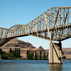
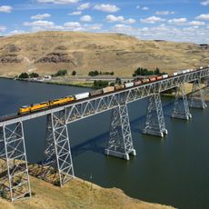
Riparia Bridge was a steel structure spanning the Snake River with three trusses, one of which could rotate to let vessels pass beneath. The movable section was operated through a hydraulic system on the main support pier.

History

George S. Morison designed this bridge for the Oregon Railroad and Navigation Company, completing it in 1889 as a pioneering steel structure. It represented early engineering innovation along the Snake River corridor.

Culture

The bridge served as a meeting point where steamboats and trains intersected, shaping how the community connected with the wider region. Visitors today can sense how this location brought different forms of transport and trade together.

Practical

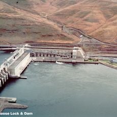
The bridge was positioned at a key junction between river and rail routes, making it accessible from several directions. Keep in mind that the site is now submerged and visible only from vantage points along the current shoreline.

Did you know?

The rotating section was one of the earliest examples of a pivoting span in North America, allowing steamboats to navigate while keeping rail traffic flowing. This engineering solution was remarkable for its time and demonstrated advanced mechanical design.

Inception
1889
GPS coordinates
46.57491,-118.09026
Latest update
December 14, 2025 18:43

AroundUs brings together thousands of curated places, local tips, and hidden gems, enriched daily by 60,000 contributors worldwide. Discover all places nearby (United States of America).

Around this place
Palouse Falls
United States of America

Palouse Falls

14.2 km
Mullan Road
United States of America

Mullan Road

23.4 km
Marmes Rockshelter
United States of America

Marmes Rockshelter

9.6 km
Fort Walla Walla
United States of America

Fort Walla Walla

62.2 km
Palouse Falls State Park
United States of America

Palouse Falls State Park

14.5 km
Lower Granite Dam
United States of America

Lower Granite Dam

51.5 km
Columbia Plateau State Park Trail
United States of America

Columbia Plateau State Park Trail

36.4 km
Little Goose Dam
United States of America

Little Goose Dam

5.1 km
Juniper Dunes Wilderness
United States of America

Juniper Dunes Wilderness

62.1 km
Lower Monumental Dam
United States of America

Lower Monumental Dam

34.2 km
Snake River Bridge
United States of America

Snake River Bridge

10 km
Borleske Stadium
United States of America

Borleske Stadium

58.6 km
Lewis and Clark Trail-Travois Road
United States of America

Lewis and Clark Trail-Travois Road

48.4 km
Joso High Bridge
United States of America

Joso High Bridge

10.8 km
Kirkman House
United States of America

Kirkman House

59.4 km
Electric Light Works Building
United States of America

Electric Light Works Building

60 km
Interior Grain Tramway
United States of America

Interior Grain Tramway

55.4 km
Nelson H. Greene House
United States of America

Nelson H. Greene House

64.8 km
Garfield County Courthouse
United States of America

Garfield County Courthouse

39.1 km
Bank of Starbuck
United States of America

Bank of Starbuck

6.7 km
Preston Hall
United States of America

Preston Hall

34.7 km
Lyons Ferry State Park
United States of America

Lyons Ferry State Park

10.7 km
Seivers Brothers Ranchhouse and Barn
United States of America

Seivers Brothers Ranchhouse and Barn

49.2 km
Walla Walla Valley Traction Company Car Barn
United States of America

Walla Walla Valley Traction Company Car Barn

60.1 km
Children's Museum of Walla Walla
United States of America

Children's Museum of Walla Walla

61.4 km
Liberty Theatre
United States of America

Liberty Theatre

59.6 km
St. Ignatius Hospital
United States of America

St. Ignatius Hospital

64.5 km
Ritzville Water Park
United States of America

Ritzville Water Park

64.6 km
Show the full map
« Riparia Bridge - Railroad bridge in Whitman County, Washington, United States » is provided by Around Us (aroundus.com). Images and texts are derived from Wikimedia project under a Creative Commons license. You are allowed to copy, distribute, and modify copies of this page, under the conditions set by the license, as long as this note is clearly visible.

Discover hidden gems everywhere you go!

From secret cafés to breathtaking viewpoints, skip the crowded tourist spots and find places that match your style. Our app makes it easy with voice search, smart filtering, route optimization, and insider tips from travelers worldwide. Download now for the complete mobile experience.

Around Us App Screenshot

A unique approach to discovering new places

Le Figaro

All the places worth exploring

France Info

A tailor-made excursion in just a few clicks

20 Minutes

Around Us
Travel Guide & Maps
Download

Send to your phone

QR Code
1

Open the camera app on your mobile.

2

Point at the QR code with your camera. A notification will appear.

3

Tap the notification to open the link.