Baishuiyang, Natural geopark in Shuangxi Town, China.
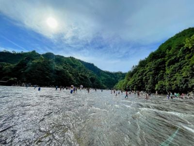
Baishuiyang is a broad, shallow riverbed of pale, uneven bedrock worn into ridges, ledges and shallow basins, washed by thin sheets of rippling water. A low stone retaining wall and a paved path where visitors walk run along its upper edge, with green vegetation beyond. The site lies in Pingnan County, Ningde, Fujian, within a 77.34 km² national geopark.
Geologists from Fuzhou University found traces of Quaternary glaciation at Baishuiyang and attributed the broad rock riverbed to glacial movement more than a million years ago; some scholars dispute this. In August 2005 it was designated a Chinese national geopark, and in 2010 it was joined with Baiyun Mountain in Fu'an and Taimu Mountain in Fuding as the Ningde UNESCO Global Geopark.
The name comes from the milky white appearance of water flowing over smooth rock. People use this place as a natural swimming and wading area, gathering in the shallow pools during warmer months.
The bedrock forms a broad, shallow riverbed crossed by thin sheets of rippling water, so wading is possible on foot. The rock is worn into ridges, ledges and shallow basins that are uneven underfoot. A low stone retaining wall and a paved path with a line of walkers run along the upper edge, giving a dry route above the water.
Fuzhou University geologists found traces of Quaternary glaciation at Baishuiyang and argued that the rock surface was shaped by glacial movement more than a million years ago. Other scholars dispute this reading, so the origin of the flat riverbed remains debated.
The community of curious travelers
AroundUs brings together thousands of curated places, local tips, and hidden gems, enriched daily by 93,685 contributors worldwide.