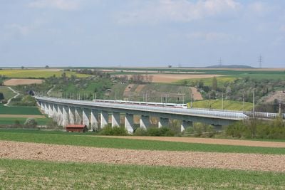
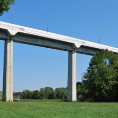
Enz Viaduct, Railway bridge in Vaihingen an der Enz, Germany
The Enz Viaduct is a railway bridge made from prestressed concrete that crosses over the Enz River valley between Mannheim and Stuttgart. Its structure uses tall concrete supports and long beam sections designed to carry heavy train loads across the entire valley span.
The bridge was built in 1989 as a modern addition to Germany's railway network connecting two major industrial centers. Its construction marked an important moment in how engineers approached long-distance train infrastructure in that era.
The bridge forms an essential part of the Mannheim-Stuttgart high-speed railway line, connecting communities and facilitating cultural exchange between major urban centers.
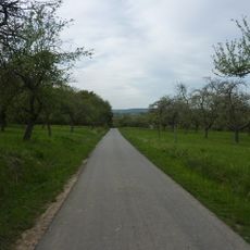
The best times to visit and photograph the structure are early morning or late afternoon when light reaches across the valley. You can view it well from nearby walking paths that run along the river and surrounding areas.
The structure uses tension cables embedded within the concrete that spread train weight evenly - a technique that makes the concrete stronger and last longer. Many visitors miss how these hidden cables hold the entire bridge together and allow it to span the valley without supports in the middle.
Location: Vaihingen an der Enz
Inception: 1989
GPS coordinates: 48.92220,9.00139
Latest update: December 14, 2025 17:04
Hochdorf Chieftain's Grave
3.8 km
Strohgäu
5.5 km
Schloss Kaltenstein
3.7 km
Schloss Unterriexingen
4.8 km
Hofgut Kleinglattbach
4 km
Schloss Riet
3.7 km
Schloss Hochdorf
4.1 km
Schloss Nussdorf
5.6 km
Frauenkirche Unterriexingen
3.7 km
Sammlung Alison & Peter W. Klein
5.3 km
Bachmühle
4.4 km
Glemstalbrücke (Markgröningen)
5.2 km
Mills in Markgröningen
5.5 km
Enztal zwischen dem Leinfelder Hof und Bietigheim-Bissingen sowie Glems- und Leudelsbachtal unterhalb Markgröningen mit angrenzenden Gebieten (insbesondere Ottern-, Berg- und Siegental, Muckenschupf und Rotenacker Wald)
3.6 km
Pfarrkirche Unterriexingen
4.2 km
Wasserturm Markgröningen
5.7 km
Heulerberg
3.5 km
Sachsenheim-Ring
4.8 km
Wasserturm Pulverdingen
2.6 km
Martinskirche
5.5 km
Lamparterhaus
3.6 km
Pflanzenstandort "Bühl"
2.4 km
Enztal zwischen Vaihingen-Roßwag und dem Leinfelder Hof
3.7 km
Altes Pfarrhaus
4.2 km
Hammelrain/Oberer Wannenberg
5.6 km
Hohlweg "Frauenklinge"
3.9 km
Sukzessionsfläche und Tümpel "Ob dem Hart"
4 km
2 Sommerlinden (Katharinenlinden)
5.3 kmVisited this place? Tap the stars to rate it and share your experience / photos with the community! Try now! You can cancel it anytime.
Discover hidden gems everywhere you go!
From secret cafés to breathtaking viewpoints, skip the crowded tourist spots and find places that match your style. Our app makes it easy with voice search, smart filtering, route optimization, and insider tips from travelers worldwide. Download now for the complete mobile experience.
A unique approach to discovering new places❞
— Le Figaro
All the places worth exploring❞
— France Info
A tailor-made excursion in just a few clicks❞
— 20 Minutes