Chest opened
+${chestReward.xp} XP
Explorer
NOUVEAU ×${chestReward.collectible.quantity}
tapez pour fermer

See the monuments around you in AR Open chests in the app

Around Us is built for your phone — point your camera at the streets and discover the monuments and places around you in augmented reality. Around Us is built for your phone — chests unlock when you walk, explore and capture nearby places.

•

Enable Location

We need your location to show you interesting places around you

Discover nearby places

Find interesting locations and hidden gems around you

Precise directions

Get accurate directions and distances to places

Your location is never shared with other users. It's only used when you tap the location button.

Mount Mihara

Log in to your account

Start exploring — it's free

Trusted by 92,727 travelers worldwide

Continue with Google
Continue with Apple
or

We will send you a code to connect

By continuing, you accept our Terms and Conditions and our Privacy Policy

Check your inbox

We've sent a pincode in your inbox. Please enter the code below.

Mount Mihara

Mount Mihara, Active volcano on Oshima Island, Japan

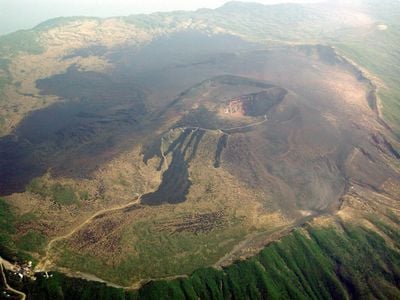
Mount Mihara is a basaltic central cone inside the caldera of Izu Ōshima, Tokyo. Its highest point, Mihara Shinzan, reaches 758 m, the island's highest summit. The cone rises about 150 m above the caldera floor, has a base diameter of roughly 1.2 km and holds a crater about 800 m wide, filled nearly flat by 1986 lava with a pit roughly 300 m across and 200 m deep toward the south.

The first record naming "Mihara" as an eruption site is a 1552 prayer plaque at a Yakushi hall in Motomachi. Major eruptions occurred in 1684–1690 and 1777, when lava overtopped the caldera wall and relief rice was granted. In 1950–51 lava buried the crater and formed Mihara Shinzan, now the island's highest point at 758 m.

Islanders have long called eruptions goshinka, the sacred fire, and the volcano itself Gojinka-sama, a fire deity to be revered. The name Mihara is traced to mihara, "belly" or womb, because the mountain discharges lava and debris flows as if giving birth. A shrine on the summit survived the 1986 eruption unharmed and is counted among Oshima's seven wonders.

The Obachi Meguri trail system leads hikers around the crater rim and offers several viewpoints overlooking the interior of the volcano. Guided tours help with orientation and provide information about current volcanic activity and safety guidelines.

The 1986 eruption sent lava fountains up to 1.6 km high and produced a 16 km subplinian plume, with a Volcanic Explosivity Index of 3. The summit shrine survived the eruption unharmed and is counted among the Seven Wonders of Oshima. The 1986 eruption also formed a rock known as Gojira Iwa, now a landmark.

The community of curious travelers

AroundUs brings together thousands of curated places, local tips, and hidden gems, enriched daily by 92,727 contributors worldwide.

Start exploring
Location
Elevation above the sea
764 m
Made from material
basalt
GPS coordinates
34.72694,139.39454
Latest update
October 25, 2026 08:06
Reviews
Share your experience

No review yet

Discussions
Start a discussion...

No discussion yet

« Mount Mihara - Active volcano on Oshima Island, Japan » is provided by Around Us (aroundus.com). Images and texts are derived from Wikimedia project under a Creative Commons license. You are allowed to copy, distribute, and modify copies of this page, under the conditions set by the license, as long as this note is clearly visible.

Discover hidden gems everywhere you go!

From secret cafés to breathtaking viewpoints, skip the crowded tourist spots and find places that match your style. Our app makes it easy with voice search, smart filtering, route optimization, and insider tips from travelers worldwide. Download now for the complete mobile experience.

Around Us App Screenshot
❝

A unique approach to discovering new places❞

— Le Figaro

❝

All the places worth exploring❞

— France Info

❝

A tailor-made excursion in just a few clicks❞

— 20 Minutes

Around Us
Travel Guide & Maps
Download

Send to your phone

QR Code
1

Open the camera app on your mobile.

2

Point at the QR code with your camera. A notification will appear.

3

Tap the notification to open the link.