·

Enable Location

We need your location to show you interesting places around you

Discover nearby places

Find interesting locations and hidden gems around you

Precise directions

Get accurate directions and distances to places

Your location is never shared with other users. It's only used when you tap the location button.

Tippecanoe County

Log in to your account

Start exploring — it's free

Trusted by 62,678 travelers worldwide

Continue with Google
Continue with Apple
or

We will send you a code to connect

By continuing, you accept our Terms and Conditions and our Privacy Policy

Check your inbox

We've sent a pincode in your inbox. Please enter the code below.

Tippecanoe County, Administrative county in Indiana, United States

Tippecanoe County is an administrative county in west-central Indiana covering about 500 square miles, with Lafayette and West Lafayette located along the Wabash River. The territory includes urban and rural areas, with Purdue University as its largest institution.

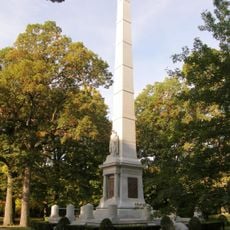
The county was established in 1826 and named after a Miami-Illinois word meaning buffalo fish. The region gained historical importance from the 1811 Battle of Tippecanoe, a key event in early American history.

Purdue University shapes how the region functions, drawing students and researchers from around the world. The university influences everyday life through its events, presence in the community, and role as a major employer.

Interstate 65 passes through and connects the county to Indianapolis and Chicago, making it easy to travel in both directions. Amtrak offers passenger rail service at Lafayette Station as an alternative to driving.

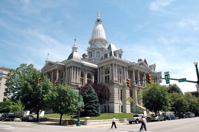
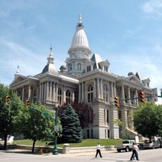
The Tippecanoe County Courthouse, built in 1881, displays Renaissance Revival architecture and stands on the National Register of Historic Places. The building features ornate details and decorative elements typical of that era.

The community of curious travelers

AroundUs brings together thousands of curated places, local tips, and hidden gems, enriched daily by 60,000 contributors worldwide.

Start exploring
Location
Inception
January 20, 1826
Capital city
Lafayette
Shares border with
White County, Carroll County, Clinton County, Montgomery County, Fountain County, Warren County, Benton County
GPS coordinates
40.39000,-86.89000
Latest update
December 17, 2025 09:32
Around this place
Ross–Ade Stadium
United States of America

Ross–Ade Stadium

5.5 km
Prophetstown State Park
United States of America

Prophetstown State Park

13.2 km
Fort Ouiatenon
United States of America

Fort Ouiatenon

6.5 km
Samara
United States of America

Samara

5.9 km
Tippecanoe Battlefield Park
United States of America

Tippecanoe Battlefield Park

13.5 km
Elliott Hall of Music
United States of America

Elliott Hall of Music

4.7 km
United States of America

Ouiatenon

6.1 km
Purdue Memorial Union
United States of America

Purdue Memorial Union

4.3 km
Engineering Fountain
United States of America

Engineering Fountain

4.7 km
Tippecanoe County Courthouse
United States of America

Tippecanoe County Courthouse

3.2 km
Slayter Center of Performing Arts
United States of America

Slayter Center of Performing Arts

5.4 km
Purdue University Horticulture Gardens
United States of America

Purdue University Horticulture Gardens

4.3 km
United States of America

The Boilermaker

5.4 km
Temple Israel
United States of America

Temple Israel

3 km
Haan Mansion Museum of Indiana Art
United States of America

Haan Mansion Museum of Indiana Art

2.6 km
Glen Hall, Indiana
United States of America

Glen Hall, Indiana

13.4 km
Cathedral of Saint Mary of the Immaculate Conception
United States of America

Cathedral of Saint Mary of the Immaculate Conception

3.1 km
Judge Cyrus Ball House
United States of America

Judge Cyrus Ball House

2.6 km
Downtown Lafayette Historic District
United States of America

Downtown Lafayette Historic District

3.2 km
Jerry E. Clegg Botanic Garden
United States of America

Jerry E. Clegg Botanic Garden

3.2 km
Former Alpha Tau Omega Fraternity House
United States of America

Former Alpha Tau Omega Fraternity House

4.8 km
Cairo Skywatch Tower
United States of America

Cairo Skywatch Tower

17 km
Centennial Neighborhood District
United States of America

Centennial Neighborhood District

3.6 km
LaFayette Fountain
United States of America

LaFayette Fountain

3.2 km
United States of America

Wabash Heritage Trail

9 km
Long Center for the Performing Arts
United States of America

Long Center for the Performing Arts

3.2 km
Upper Main Street Historic District
United States of America

Upper Main Street Historic District

3.3 km
Farmers Institute
United States of America

Farmers Institute

11.5 km
Show the full map
Administrative divisions
« Tippecanoe County - Administrative county in Indiana, United States » is provided by Around Us (aroundus.com). Images and texts are derived from Wikimedia project under a Creative Commons license. You are allowed to copy, distribute, and modify copies of this page, under the conditions set by the license, as long as this note is clearly visible.

Discover hidden gems everywhere you go!

From secret cafés to breathtaking viewpoints, skip the crowded tourist spots and find places that match your style. Our app makes it easy with voice search, smart filtering, route optimization, and insider tips from travelers worldwide. Download now for the complete mobile experience.

Around Us App Screenshot

A unique approach to discovering new places

Le Figaro

All the places worth exploring

France Info

A tailor-made excursion in just a few clicks

20 Minutes

Around Us
Travel Guide & Maps
Download

Send to your phone

QR Code
1

Open the camera app on your mobile.

2

Point at the QR code with your camera. A notification will appear.

3

Tap the notification to open the link.