Chest opened
+${chestReward.xp} XP
Explorer
NOUVEAU ×${chestReward.collectible.quantity}
tapez pour fermer
Chest locked

Open chests in the app

Around Us is built for your phone — chests unlock when you walk, explore and capture nearby places.

Enable Location

We need your location to show you interesting places around you

Discover nearby places

Find interesting locations and hidden gems around you

Precise directions

Get accurate directions and distances to places

Your location is never shared with other users. It's only used when you tap the location button.

Log in to your account

Start exploring — it's free

Trusted by 73,009 travelers worldwide

Continue with Google
Continue with Apple
or

We will send you a code to connect

By continuing, you accept our Terms and Conditions and our Privacy Policy

Check your inbox

We've sent a pincode in your inbox. Please enter the code below.

State of Franklin
Discussion Reviews Photo
88k Popularity

State of Franklin, Historical territory in Eastern Tennessee, United States

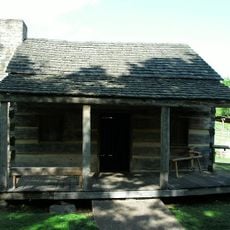
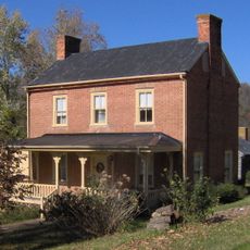
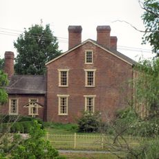
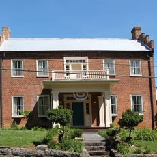
The State of Franklin was an independent territory in eastern present-day Tennessee that stretched across the Appalachian Mountains between North Carolina and other frontier areas. The region contained several towns and settlements with Jonesborough and later Greeneville serving as administrative centers.

After North Carolina ceded the land to Congress in 1784, settlers established this independent territory as an early attempt at self-governance. The experiment ended in 1789 when the region returned to North Carolina control.

The people who lived here built their own local government and made decisions without waiting for approval from distant authorities. They created laws and institutions that reflected the needs of settlers who had moved to this mountain region to start fresh lives.

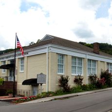
The historical region today is spread across Tennessee and can be explored by visiting different towns such as Jonesborough and Greeneville. Museums and historic sites in these locations provide information about this brief period of independence.

Residents paid taxes to two different governments at the same time because the region was claimed by both North Carolina and the local Sevier-led government. This unusual double loyalty made the territory a place of conflicting political claims.

The community of curious travelers

AroundUs brings together thousands of curated places, local tips, and hidden gems, enriched daily by 60,000 contributors worldwide.

Start exploring
Location
Inception
August 1784
GPS coordinates
36.16670,-82.81670
Latest update
December 18, 2025 11:41
Around this place
Andrew Johnson National Cemetery
United States of America

Andrew Johnson National Cemetery

2.3 km
Davy Crockett Birthplace State Park
United States of America

Davy Crockett Birthplace State Park

15 km
Earnest Farms Historic District
United States of America

Earnest Farms Historic District

12.7 km
Amis House
United States of America

Amis House

30.8 km
Greeneville Historic District
United States of America

Greeneville Historic District

1.3 km
Rogersville Historic District
United States of America

Rogersville Historic District

31.7 km
Jonesborough Historic District
United States of America

Jonesborough Historic District

33.9 km
Lamar Alexander Rocky Fork State Park
United States of America

Lamar Alexander Rocky Fork State Park

25.6 km
Hawkins County Courthouse
United States of America

Hawkins County Courthouse

31.7 km
Swaggerty Blockhouse
United States of America

Swaggerty Blockhouse

28.6 km
United States of America

Overton Lodge

32 km
Bulls Gap Historic District
United States of America

Bulls Gap Historic District

26.2 km
Conway Bridge
United States of America

Conway Bridge

28.1 km
Maden Hall Farm
United States of America

Maden Hall Farm

6 km
Price Public Elementary School
United States of America

Price Public Elementary School

32.1 km
St. Marks Presbyterian Church
United States of America

St. Marks Presbyterian Church

32 km
Rural Mount
United States of America

Rural Mount

33.6 km
New Providence Presbyterian Church, Academy, and Cemetery
United States of America

New Providence Presbyterian Church, Academy, and Cemetery

36.6 km
Salem Presbyterian Church
United States of America

Salem Presbyterian Church

22.7 km
Stony Point
United States of America

Stony Point

35.9 km
A.R. Brown House
United States of America

A.R. Brown House

35.9 km
Thomas Telford House
United States of America

Thomas Telford House

19.6 km
Jonesborough United Methodist Church
United States of America

Jonesborough United Methodist Church

33.7 km
Henry Hoss House
United States of America

Henry Hoss House

35.3 km
Gate City Historic District
United States of America

Gate City Historic District

26.1 km
Sunnybank
United States of America

Sunnybank

30.7 km
Waterfall on West Prong Hickey Fork
United States of America

Waterfall on West Prong Hickey Fork

21 km
Sulphur Springs Methodist Campground
United States of America

Sulphur Springs Methodist Campground

31.9 km
Show the full map
Reviews
Share your experience

No review yet

Discussions
Start a discussion...

No discussion yet

« State of Franklin - Historical territory in Eastern Tennessee, United States » is provided by Around Us (aroundus.com). Images and texts are derived from Wikimedia project under a Creative Commons license. You are allowed to copy, distribute, and modify copies of this page, under the conditions set by the license, as long as this note is clearly visible.

Discover hidden gems everywhere you go!

From secret cafés to breathtaking viewpoints, skip the crowded tourist spots and find places that match your style. Our app makes it easy with voice search, smart filtering, route optimization, and insider tips from travelers worldwide. Download now for the complete mobile experience.

Around Us App Screenshot

A unique approach to discovering new places

Le Figaro

All the places worth exploring

France Info

A tailor-made excursion in just a few clicks

20 Minutes

Around Us
Travel Guide & Maps
Download

Send to your phone

QR Code
1

Open the camera app on your mobile.

2

Point at the QR code with your camera. A notification will appear.

3

Tap the notification to open the link.