Enable Location

We need your location to show you interesting places around you

Discover nearby places

Find interesting locations and hidden gems around you

Precise directions

Get accurate directions and distances to places

Your location is never shared with other users. It's only used when you tap the location button.

Beartown State Park

Log in to your account

Start exploring — it's free

Trusted by 62,526 travelers worldwide

Continue with Google
Continue with Apple
or

We will send you a code to connect

By continuing, you accept our Terms and Conditions and our Privacy Policy

Check your inbox

We've sent a pincode in your inbox. Please enter the code below.

Beartown State Park

Beartown State Park, Natural area with rock formations in Pocahontas County, United States.

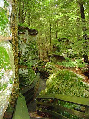
Beartown State Park is a natural area in Pocahontas County featuring massive sandstone boulders, deep crevices, and cliffs shaped through geological processes over millions of years. The roughly 45-acre park displays impressive rock formations that visitors can explore on protected walkways.

The Nature Conservancy acquired the land in 1970 through a donation from Mrs. Edwin Polan in memory of her son who died in Vietnam. This gift enabled the long-term preservation of this geologically significant site for future generations.

The park takes its name from cave openings where black bears sheltered through winter and from narrow passages between rocks that resemble streets in a town.

A half-mile boardwalk guides visitors through the area while protecting the natural surroundings and providing access to rock formations. Wearing comfortable shoes and staying on marked paths helps ensure safety and preserves the environment.

Erosion and faulting of Pottsville Sandstone created a network of passages between rock walls that form a natural stone maze. This system developed over millions of years as natural forces broke the stone into unexpected patterns.

The community of curious travelers

AroundUs brings together thousands of curated places, local tips, and hidden gems, enriched daily by 60,000 contributors worldwide.

Start exploring
Location
Inception
1970
Elevation above the sea
1,035 m
GPS coordinates
38.05220,-80.27560
Latest update
December 6, 2025 17:41
Nature areas and historic sites in West Virginia

West Virginia brings together natural landscapes and historical places. The state features waterfalls, mountain peaks, caves and old railroad lines that invite exploration. Visitors discover national forests, battlefields from America's past and mineral springs that have drawn people for...

Around this place
The Greenbrier
United States of America

The Greenbrier

29.8 km
Project Greek Island
United States of America

Project Greek Island

29.7 km
Lost World Caverns
United States of America

Lost World Caverns

28.7 km
Greenbrier River Trail
United States of America

Greenbrier River Trail

24.7 km
Cranberry Wilderness
United States of America

Cranberry Wilderness

25.5 km
Watoga State Park
United States of America

Watoga State Park

12.4 km
Droop Mountain Battlefield State Park
United States of America

Droop Mountain Battlefield State Park

6.4 km
Pearl S. Buck Birthplace
United States of America

Pearl S. Buck Birthplace

11.7 km
Big Draft Wilderness
United States of America

Big Draft Wilderness

14.7 km
Spice Run Wilderness
United States of America

Spice Run Wilderness

3.9 km
Renick Farm
United States of America

Renick Farm

10.1 km
Pocahontas Times Print Shop
United States of America

Pocahontas Times Print Shop

24.8 km
Sunshine Farm and Gardens
United States of America

Sunshine Farm and Gardens

13.9 km
Pocahontas County Opera House
United States of America

Pocahontas County Opera House

24.7 km
Frank and Anna Hunter House
United States of America

Frank and Anna Hunter House

24.2 km
Pocahontas County Courthouse and Jail
United States of America

Pocahontas County Courthouse and Jail

24.7 km
Edgefield
United States of America

Edgefield

9.4 km
McNeel Mill
United States of America

McNeel Mill

14.3 km
United States of America

Pleasant Green Methodist Episcopal Church

12.5 km
Downtown Richwood Historic District
United States of America

Downtown Richwood Historic District

29.7 km
Gov. Samuel Price House
United States of America

Gov. Samuel Price House

31.3 km
IOOF Lodge Building
United States of America

IOOF Lodge Building

24.8 km
McClung's Price Place
United States of America

McClung's Price Place

21.5 km
Droop Mountain Battlefield State Park
United States of America

Droop Mountain Battlefield State Park

6.6 km
Greenbrier County Courthouse
United States of America

Greenbrier County Courthouse

31.5 km
Locust Creek Covered Bridge
United States of America

Locust Creek Covered Bridge

3.8 km
Lewisburg Historic District
United States of America

Lewisburg Historic District

29.1 km
James Withrow House
United States of America

James Withrow House

31.3 km
Show the full map
« Beartown State Park - Natural area with rock formations in Pocahontas County, United States » is provided by Around Us (aroundus.com). Images and texts are derived from Wikimedia project under a Creative Commons license. You are allowed to copy, distribute, and modify copies of this page, under the conditions set by the license, as long as this note is clearly visible.

Discover hidden gems everywhere you go!

From secret cafés to breathtaking viewpoints, skip the crowded tourist spots and find places that match your style. Our app makes it easy with voice search, smart filtering, route optimization, and insider tips from travelers worldwide. Download now for the complete mobile experience.

Around Us App Screenshot

A unique approach to discovering new places

Le Figaro

All the places worth exploring

France Info

A tailor-made excursion in just a few clicks

20 Minutes

Around Us
Travel Guide & Maps
Download

Send to your phone

QR Code
1

Open the camera app on your mobile.

2

Point at the QR code with your camera. A notification will appear.

3

Tap the notification to open the link.