Enable Location

We need your location to show you interesting places around you

Discover nearby places

Find interesting locations and hidden gems around you

Precise directions

Get accurate directions and distances to places

Your location is never shared with other users. It's only used when you tap the location button.

Coudersport Historic District

Log in to your account

Start exploring — it's free

Trusted by 63,306 travelers worldwide

Continue with Google
Continue with Apple
or

We will send you a code to connect

By continuing, you accept our Terms and Conditions and our Privacy Policy

Check your inbox

We've sent a pincode in your inbox. Please enter the code below.

Discussion Reviews 1 Photos
1.2k Popularity

Coudersport Historic District, Historic district in Coudersport, Pennsylvania.

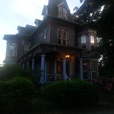
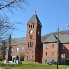
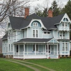
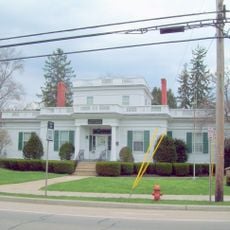
The Coudersport Historic District comprises 73 buildings nestled in a narrow valley along the Allegheny River, displaying Late Victorian and Queen Anne architectural styles. The structures vary in size and detail, reflecting how the town grew and changed across generations.

The town experienced major growth during the 19th-century lumber boom, when companies harvested vast quantities of white pine and hemlock from surrounding forests. This economic prosperity attracted workers and business owners who built most of the structures you see today.

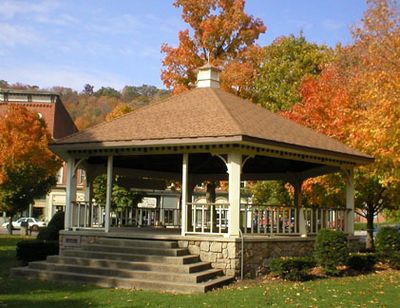
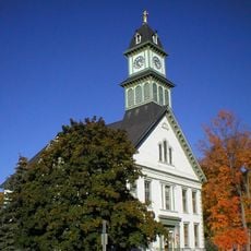
The Courthouse Square forms the social heart of the district, with churches like Park United Methodist and Presbyterian serving as gathering places that shaped community life. These buildings reflect how faith and civic identity were woven into daily routines.

Walking through the narrow valley streets is the best way to explore the buildings and appreciate their architectural details from the outside. Many structures remain private residences or businesses, so plan to view and photograph from the public right of way.

When timber resources dwindled in the early 20th century, the town stagnated rather than evolving like many other communities, which accidentally protected the original character. This slowdown means you see buildings much as they were built, largely unmodified by decades of redevelopment.

The community of curious travelers

AroundUs brings together thousands of curated places, local tips, and hidden gems, enriched daily by 60,000 contributors worldwide.

Start exploring
Location
GPS coordinates
41.77556,-78.02278
Latest update
December 14, 2025 18:41
Around this place
Cherry Springs State Park
United States of America

Cherry Springs State Park

20.8 km
Kinzua Bridge State Park
United States of America

Kinzua Bridge State Park

46.6 km
Colton Point State Park
United States of America

Colton Point State Park

47 km
Ole Bull State Park
United States of America

Ole Bull State Park

37.1 km
Kettle Creek State Park
United States of America

Kettle Creek State Park

43.6 km
Lyman Run State Park
United States of America

Lyman Run State Park

21.3 km
Sinnemahoning State Park
United States of America

Sinnemahoning State Park

36.5 km
Hammersley Wild Area
United States of America

Hammersley Wild Area

31.5 km
Bucktail State Park Natural Area
United States of America

Bucktail State Park Natural Area

33.7 km
Denton Hill State Park
United States of America

Denton Hill State Park

16 km
Sizerville State Park
United States of America

Sizerville State Park

24.7 km
Eldred World War II Museum
United States of America

Eldred World War II Museum

36.4 km
Lynn Hall
United States of America

Lynn Hall

24.3 km
Pennsylvania Lumber Museum
United States of America

Pennsylvania Lumber Museum

16.6 km
Patterson State Park
United States of America

Patterson State Park

14 km
Forrest H. Duttlinger Natural Area
United States of America

Forrest H. Duttlinger Natural Area

36 km
Conklin Mountain House
United States of America

Conklin Mountain House

47.4 km
Cameron County Courthouse
United States of America

Cameron County Courthouse

34.2 km
Pfeiffer-Wheeler American Chestnut Cabin
United States of America

Pfeiffer-Wheeler American Chestnut Cabin

43.6 km
Bedford Corners Historic District
United States of America

Bedford Corners Historic District

39.1 km
William E. Wheeler House
United States of America

William E. Wheeler House

39.5 km
Portville Free Library
United States of America

Portville Free Library

39.4 km
House at 520 Hostageh Road
United States of America

House at 520 Hostageh Road

45.7 km
Potter County Courthouse
United States of America

Potter County Courthouse

222 m
Cherry Springs Picnic Pavilion
United States of America

Cherry Springs Picnic Pavilion

20.9 km
Colton Point State Park Historic District
United States of America

Colton Point State Park Historic District

47 km
Susquehannock State Forest
United States of America

Susquehannock State Forest

18.8 km
Coudersport Theatre
United States of America

Coudersport Theatre

423 m
Show the full map
Reviews
Share your experience

No review yet

Discussions
Start a discussion...

No discussion yet

« Coudersport Historic District - Historic district in Coudersport, Pennsylvania » is provided by Around Us (aroundus.com). Images and texts are derived from Wikimedia project under a Creative Commons license. You are allowed to copy, distribute, and modify copies of this page, under the conditions set by the license, as long as this note is clearly visible.

Discover hidden gems everywhere you go!

From secret cafés to breathtaking viewpoints, skip the crowded tourist spots and find places that match your style. Our app makes it easy with voice search, smart filtering, route optimization, and insider tips from travelers worldwide. Download now for the complete mobile experience.

Around Us App Screenshot

A unique approach to discovering new places

Le Figaro

All the places worth exploring

France Info

A tailor-made excursion in just a few clicks

20 Minutes

Around Us
Travel Guide & Maps
Download

Send to your phone

QR Code
1

Open the camera app on your mobile.

2

Point at the QR code with your camera. A notification will appear.

3

Tap the notification to open the link.