See the monuments around you in AROpen chests in the app
Around Us is built for your phone — point your camera at the streets and discover the monuments and places around you in augmented reality.Around Us is built for your phone — chests unlock when you walk, explore and capture nearby places.
What to see on Oléron Island: tourist sites, historical monuments, and beaches to visit
Oléron Island, the largest island in mainland France after Corsica, features a military, maritime, and natural heritage reflecting its strategic position facing the Atlantic Ocean. This Charente island, connected to the mainland since 1966 by a nearly three-kilometer-long bridge, houses fortifications built under Louis XIV, such as the Citadel of Château d'Oléron and Fort Louvois, as well as the famous Fort Boyard positioned on its sandbank offshore. The Chassiron Lighthouse, standing at forty-six meters high, marks the northern tip of the island and guides ships through the waters of the Pertuis d'Antioche.
Beyond its defensive legacy, the island offers various natural areas where sandy beaches, pine forests, and salt marshes alternate. Saint-Trojan-les-Bains extends its wooded shoreline to the south, while Boyardville features a protected coast on its eastern side. Visitors also observe oyster farming along the La Baudissière channel and explore the colorful huts that house artist workshops at the port of Château d'Oléron. The Saltworks Museum traces the history of salt extraction, a resource that shaped the local economy for centuries.
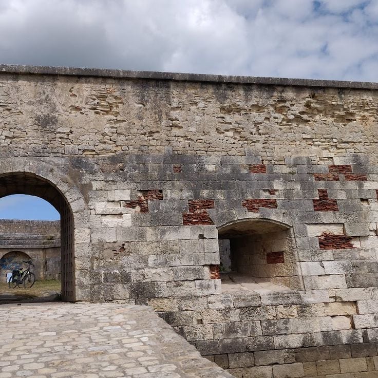
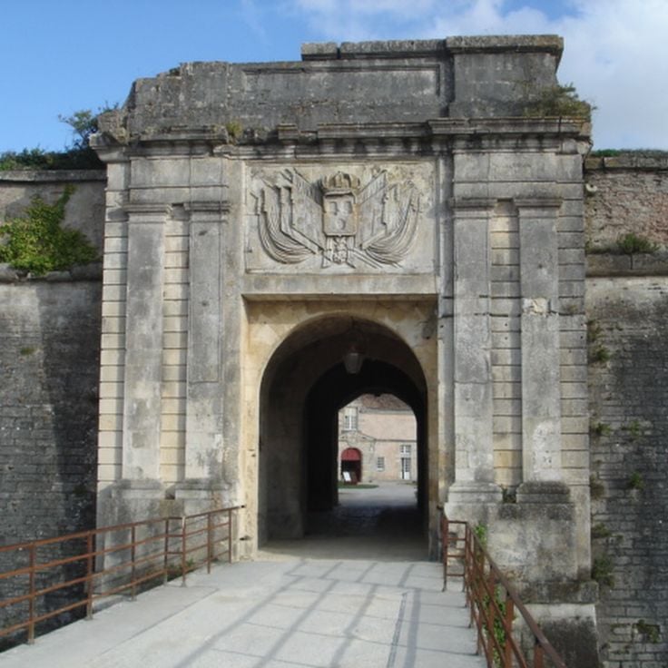
This citadel was built under Louis XIV to protect the Atlantic coast and secure the passage through the Pertuis de Maumusson against enemy vessels. The fortification forms the core of the defensive system on Oléron Island and illustrates the military architecture of the 17th century. Its bastions and ramparts reflect the strategic importance the island held within the French coastal defense during the era of Vauban.
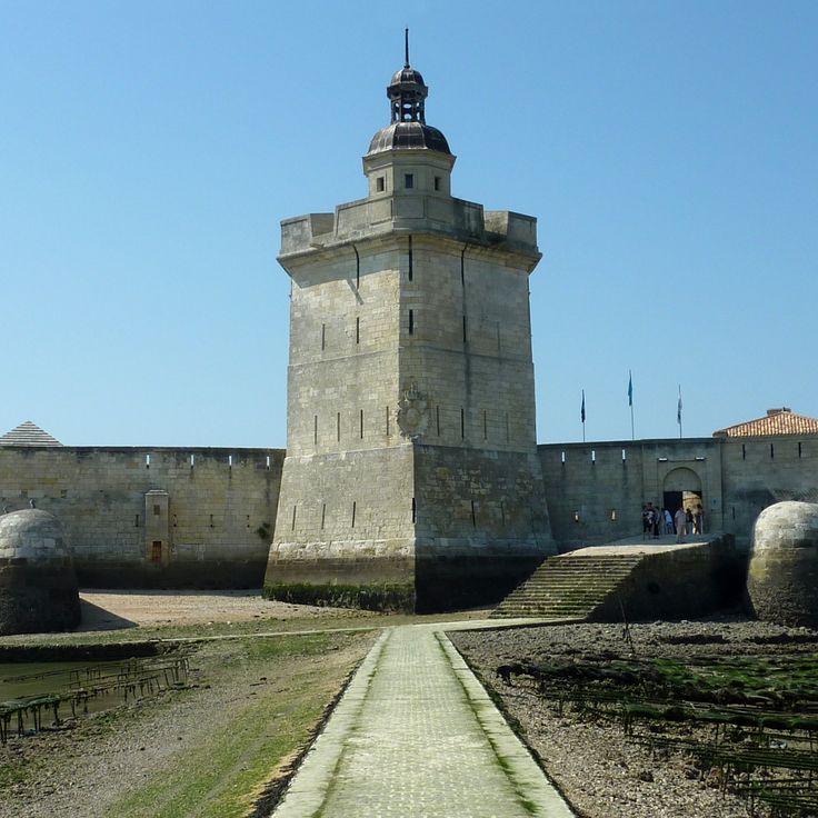
This defensive structure rises from a rocky islet off the coast of Oléron and was built in the seventeenth century under Louis XIV to protect the approaches to the Charente River. A causeway connects the fort to the mainland but floods at high tide, making access possible only at low tide or by boat. The fortification complements the military heritage of the island, which includes the Citadel of Château d'Oléron and Fort Boyard positioned offshore. Visitors can explore the ramparts, casemates, and the central building that now houses a museum.
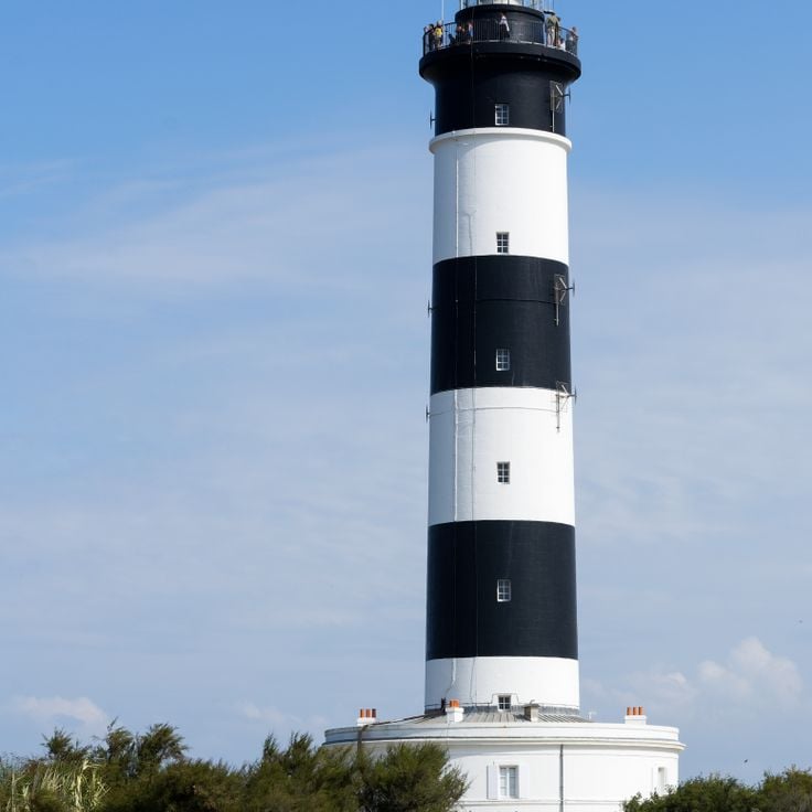
This lighthouse rises 151 feet (46 meters) above sea level at the northern tip of Oléron Island, marking the northern entrance to the Pertuis d'Antioche, which separates the mainland from the island. Built in 1836, the structure replaced an earlier tower from the seventeenth century and has served navigation in these waters characterized by currents and shoals for nearly two centuries. The black and white striped tower contains 224 steps leading to the observation platform, from which visitors can view the western coastline of the island, the Gironde estuary to the south, and on clear days the mainland coast to the east. At the base of the lighthouse, a museum provides information on the history of beacons in the region and the evolution of navigation techniques.
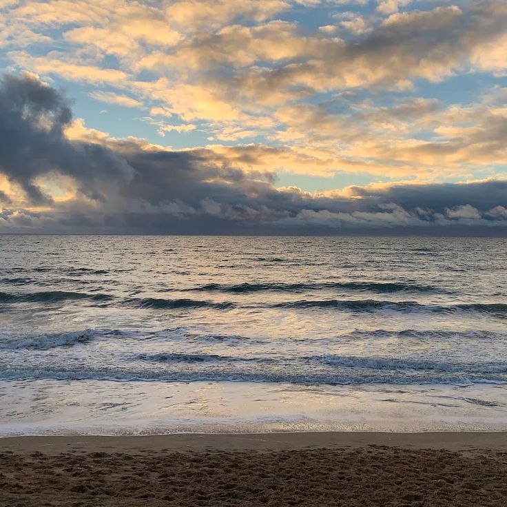
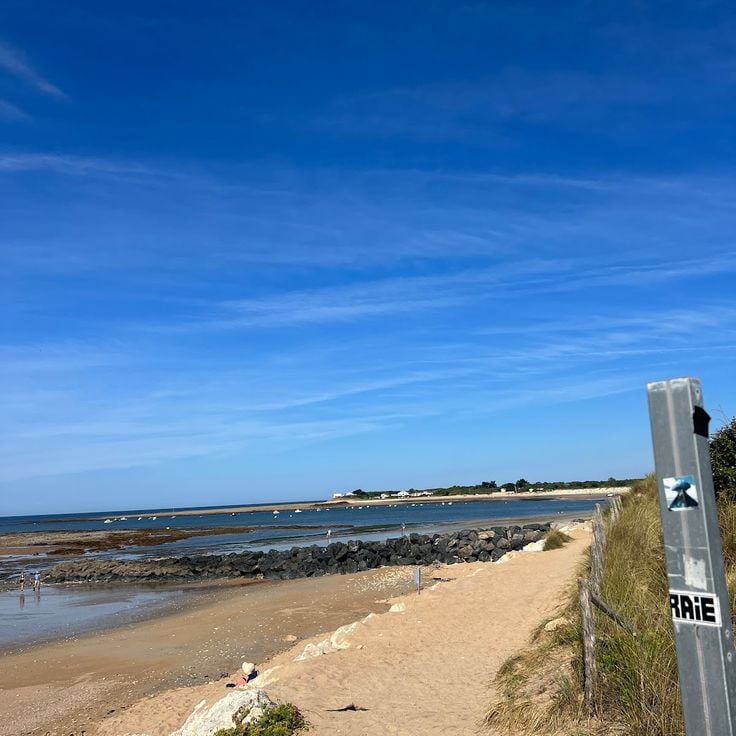
Saint-Trojan-les-Bains sits at the southern tip of Oléron Island and serves as a coastal resort where visitors find sandy beaches and an extensive maritime pine forest reaching the shoreline. This section of the island provides access to several beaches along the Atlantic coast and walking trails through the forested dunes. The town functions as a starting point for excursions into the southern natural areas of the island, where pines and holm oaks shape the landscape. The beaches extend for several miles and attract both bathers and surfers.
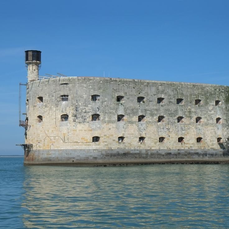
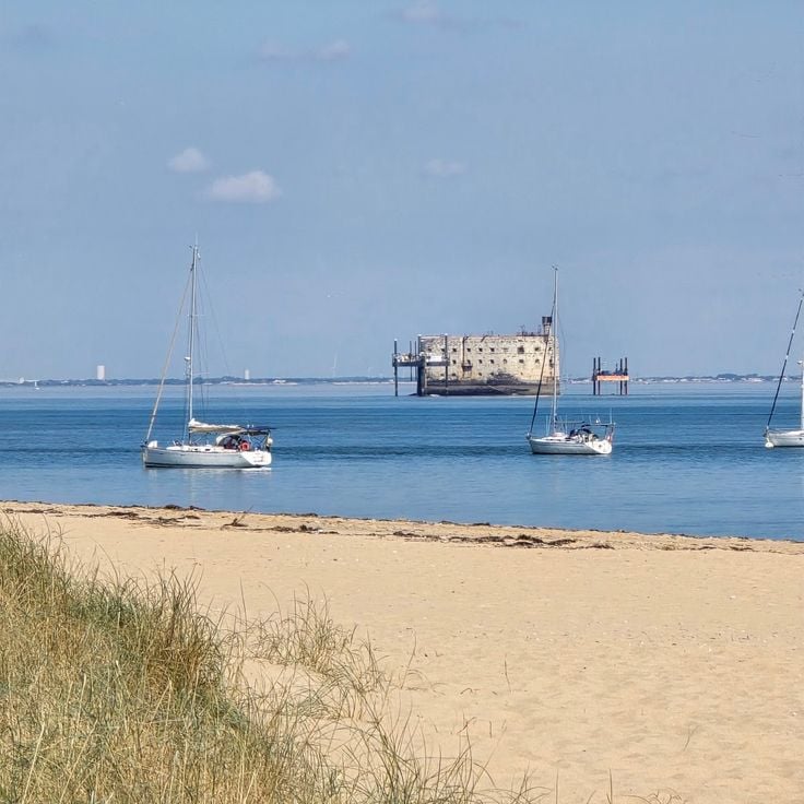
This oval military construction rises from a sandbank between Oléron Island and Île d'Aix. Fort Boyard was built over more than three decades during the nineteenth century to control access to the Charente estuary. The structure lost its strategic purpose before completion, however, and never served its intended military function. Since the 1990s the fort has housed a television production that brought it international recognition. Visitors cannot tour the interior, but numerous boat operators offer circuits around the structure, allowing travelers to observe the architecture and its exposed position in open water between the islands.
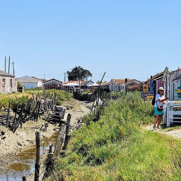
This cluster of painted wooden cabins lines the harbor basin at Château d'Oléron, where painters, sculptors and artisans have set up studios over the past few decades. Once used by fishermen for storing nets and gear, the structures now serve as workshops and sales spaces where visitors can watch the creative process and purchase original works. The cabins form a recognizable part of the island's identity and show how historic port buildings have been repurposed for artistic use while maintaining a connection to the maritime tradition of the settlement.
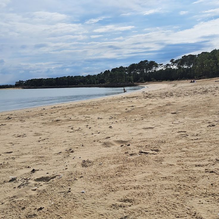
This sandy beach on the east coast of the island lies sheltered from west winds and offers views of Fort Boyard offshore. Boyardville Beach occupies a calmer side of Oléron, facing away from the open Atlantic, and draws families and visitors who prefer gentler surf. The shallow water extends across a wide expanse, allowing children to play in the shallows. From here, you can make out the oval silhouette of Fort Boyard sitting on its sandbank several hundred yards offshore.
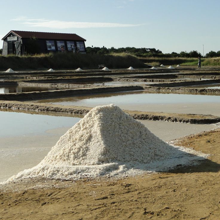
These former salt pans at the southern end of Oléron represent one of the historic production sites that shaped the island's economy for centuries. The site has been converted into an open-air museum that demonstrates traditional methods of sea salt extraction and explains the economic importance of this activity for local communities. Visitors follow a marked trail through the basins and channels, where panels detail each stage of the production process. The grounds also provide insight into the work of the paludiers who harvested salt by hand, as well as the changes this industry experienced over time.
This channel, which connects the area to the port of Château d'Oléron, is lined with colorful wooden cabins where local artists maintain their workshops and oyster farmers sell their products. The traditional maritime architecture of these structures reflects the economic history of the island, shaped for centuries by oyster farming. Visitors can walk along the waterway and observe the connection between artisan activity and maritime heritage that characterizes this part of Oléron.
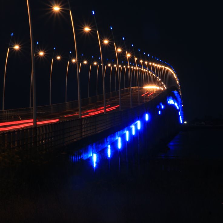
This road bridge was inaugurated in 1966 and connects the island to the French mainland over a distance of 9,390 feet (2,862 meters) with no toll. The structure ended centuries of reliance on ferry connections and enabled direct access to the continental road network. The bridge facilitates travel to the fortifications, lighthouses and natural landscapes of Oléron Island, the second largest island in mainland France after Corsica. It spans the strait between Bourcefranc-le-Chapus on the mainland and the eastern coast of the island.
This fort stands on the southeastern shore of Oléron near Bourcefranc-le-Chapus. It was built in the mid-nineteenth century to defend the coastal area and later abandoned as military priorities shifted. Today the site serves as a nature reserve that combines oyster farming operations with protected habitats for native plants and animals. Visitors explore the preserved stone structures and observe wading birds that feed in the shallow waters and salt marshes surrounding the fort. The reserve offers insight into how former military installations on the island have been adapted for ecological and economic purposes.
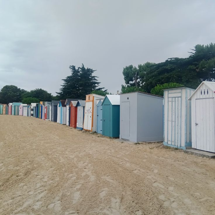
This beach sits in the northern part of the island and draws families seeking calm waters and flat terrain. The colorful beach cabins in traditional style line the shore and provide shelter from wind and sun. The area features stretches of sand that extend widely at low tide and allow for walks along the water. Infrastructure includes parking facilities and basic amenities for visitors during the summer season.
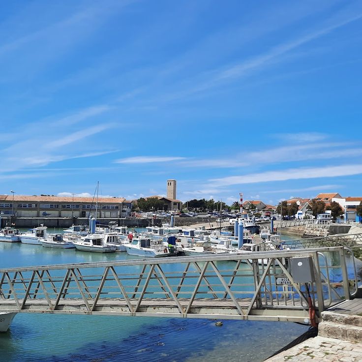
This harbor on the western coast of Oléron Island has served as a shelter for the fishing fleet since the nineteenth century. La Cotinière was equipped with jetties and breakwaters starting in the 1850s to provide vessels with a safe port of call. Fishermen working from the harbor catch sole, sea bass and other species using longlines and pots. Each morning, boats return with the catch, which is then sold at the auction hall. Visitors can watch the trawlers arrive and walk along the quay where fish merchants prepare the goods for restaurants and markets. The quay wall provides a view of the bay and the harbor entrance, while the adjoining district houses shops and restaurants specializing in seafood.
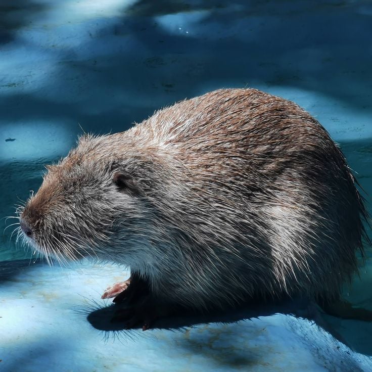
This park on the eastern side of Oléron Island has allowed visitors to observe coypus and other waterfowl in their natural habitat for over three decades. The facility extends across several ponds where visitors can watch these South American rodents swimming and feeding. In addition to coypus, the site is home to ducks, geese, and other bird species that inhabit the freshwater areas of the island. Information panels explain the biology of these animals and their establishment in the region. The park offers an alternative to the beaches and fortifications that define Oléron's tourism landscape.
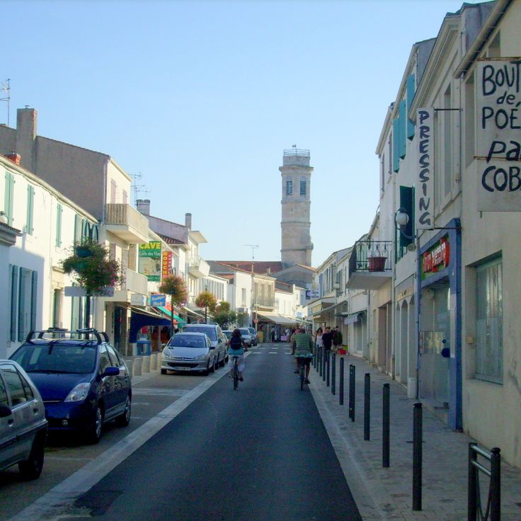
This town has served as the island's administrative center since 1852, bringing together shops, services and public facilities at a central location. The traditional market on Place Gambetta gathers vendors and producers several times a week, while commercial streets provide visitors with a practical base for supplies. A 19th-century bandstand stands in the center of the main square, illustrating the social role such structures played in community organization. The Church of Saint-Pierre, in its current form dating from the 18th century, marks the town's religious heritage.
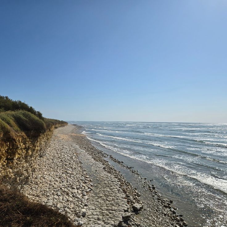
This sandy beach on the west coast of the island offers direct views of the Atlantic Ocean and is frequently used by visitors for walking. The beach extends for several miles (several kilometers) south of Saint-Trojan-les-Bains and borders an extensive pine forest that provides natural shade and shelter from the wind. Atlantic waves and tides shape the character of this coastal stretch, popular with both swimmers and surfers. The Grande Plage forms one of the longest continuous beach sections on Oléron and connects the natural environment of the island with its maritime heritage.
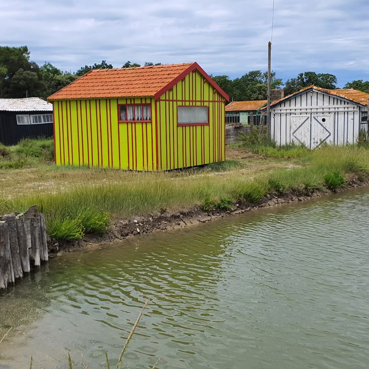
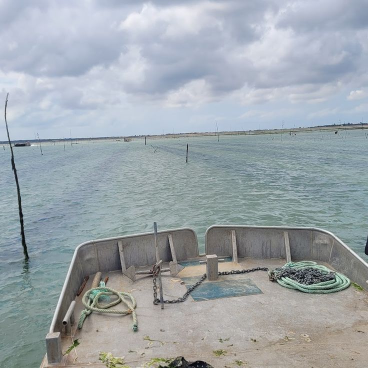
This waterway is lined with colorful oyster huts where farming has continued for generations, creating a typical scene along the coast of Oléron Island. The wooden structures, painted in shades of red, blue and green, stand on pilings above the water and serve as work spaces and sales points for oyster producers. The Chenal de la Brande is one of several channels on the island where visitors observe maritime work and purchase fresh oysters directly from growers. The site demonstrates the economic role of oyster farming for Oléron and the Charente-Maritime region.
This wreck recalls the perils of Atlantic shipping and adds to the maritime heritage of Oléron Island. The Presidente Viera, a Portuguese cargo vessel, ran aground in January 1916 and has remained off the coast of Saint-Trojan-les-Bains ever since. At low tide, the metal hull becomes visible, allowing visitors to observe the remains of the ship that became part of the regional history of maritime navigation. Access is on foot from the beach when tides permit, offering a perspective on the nautical risks faced by merchant vessels during the early twentieth century.
This beach in Saint-Trojan-les-Bains lies sheltered along the southern coast of Oléron, offering families straightforward access to fine sand. The bay benefits from calmer waters than those on the western shore, making it suitable for visitors with children. Facilities such as showers and lifeguards operate during the summer season. The beach extends for several hundred yards and borders wooded areas that provide shade. The setting combines the military and maritime elements that define Oléron with the natural coastal landscapes visitors discover throughout the island.
The Chenal d'Arceau on Oléron Island is a natural waterway lined with wooden huts where oyster farmers work and cultivate their shellfish using methods passed down through generations. This waterway reflects the traditional oyster farming that has shaped the island's economy for centuries.
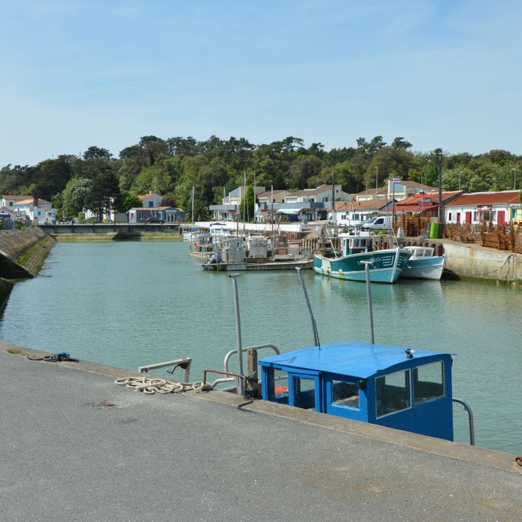
This harbor supports fishing and oyster farming activities that sustain the maritime economy of Oléron Island. Colored huts line the docks where fishermen and oyster farmers store equipment and carry out daily operations. The La Baudissière channel connects the harbor basin to open waters, providing access to oyster beds that stretch along the eastern shore of the island. Visitors observe boats being prepared, catches being unloaded, and facilities being maintained, all part of work that has supported the local community for generations.
This Atlantic beach on the northern part of Oléron offers fine sand and consistent waves that attract surfers of all levels, bodyboarders and kitesurfers throughout the year. The exposed position at the tip of the island generates regular swells that make this beach one of the most frequented spots for water sports on Oléron. The wide sandy area provides space for both beginners and experienced surfers, and facilities include parking areas and beach access points near the dunes.
This thalassotherapy center uses seawater and marine algae for therapeutic treatments focused on relaxation, physical recovery and health care. The facility offers a range of treatments including water massage, algae wraps and marine mud applications that draw on the mineral properties of the Atlantic. The center is located in Saint-Trojan-les-Bains at the southern tip of Oléron Island, where the combination of ocean climate and forested coastal landscape supports the therapeutic effects of the treatments. In addition to medical applications, the facility includes fitness areas and pools filled with heated seawater.
This headland marks the northern point of Oléron Island and forms the geographic boundary between the Atlantic Ocean and the waters of the Pertuis d'Antioche. The promontory extends into a shipping area where currents and shoals have shaped navigation and defensive installations for centuries. The Chassiron Lighthouse has stood here since 1836 and was raised several times to improve its range. Visitors can explore the grounds around the tower, where gardens featuring medicinal plants and maritime species have been established. From this point, views extend across the coastal sections of the island and neighboring landmasses.
This sandy beach on the Atlantic coast of Île d'Oléron attracts surfers who take advantage of the consistent waves that this location provides. The beach fits into the natural diversity of the island, where stretches of shoreline, dunes, and pine forests alternate. The exposed western coast of Oléron receives Atlantic swells directly, creating conditions suitable for both beginners and more experienced wave riders. Access follows paths that lead through wooded hinterland, and infrastructure remains limited to essentials.
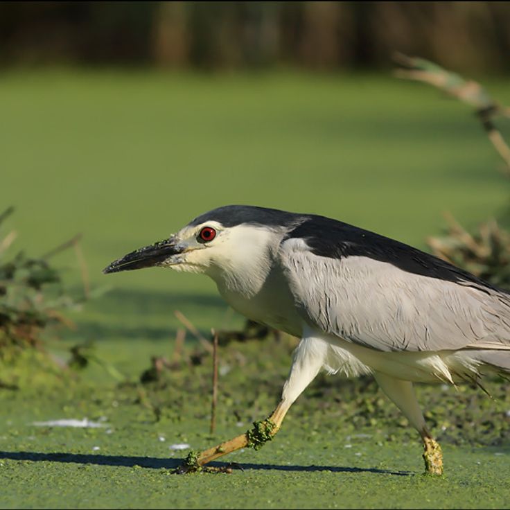
The Marais aux Oiseaux extends over one hundred twenty hectares in the center of Oléron Island and provides a protected habitat for resident and migratory birds. The area includes wetlands, ponds and reed zones where several observation posts have been installed along marked trails. Visitors discover species such as herons, ducks and shorebirds that use this environment. An educational trail informs about the habitats and conservation efforts adapted to the natural conditions of this part of the island.
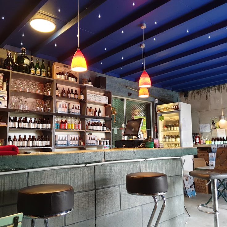
This brewery, founded in 2009 on Île d'Oléron, produces beer using traditional methods without chemical additives or artificial coloring agents. The name references Fort Boyard, positioned offshore on its sandbank near the island. The brewery offers visitors an opportunity to discover the craft of beer production, an activity that complements the culinary offerings of the largest island in mainland France after Corsica. The beers are produced in small batches and reflect the maritime tradition of this Atlantic region. Guided tours explain the various stages of production, and tasting sessions allow sampling of the different varieties created by this craft establishment.
This tourist train crosses the state forest and connects the center of Saint-Trojan-les-Bains with Grande Plage beach over a route of several miles through pine forests. Le P'tit Train has operated along this route for decades, providing visitors with transportation between the southern island area and the Atlantic coast. The journey passes through the wooded dune terrain that characterizes the southern section of Oléron and forms part of the larger forest area extending across this side of the island.
This museum presents collections on the island's history, maritime traditions, oyster farming, and the trades practiced here for centuries. The exhibits document the economic and cultural development of Oléron, from salt extraction through seafaring to present-day oyster production. Visitors explore tools, photographs, and objects that illustrate the daily life of island residents and demonstrate their connection to the Atlantic.
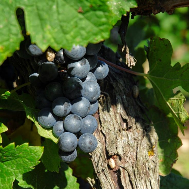
This family winery cultivates grape varieties adapted to the island's soils and produces dry white wines, light reds, and fresh rosés. The parcels are located in an area where proximity to the Atlantic influences the microclimate and salt laden air from the ocean reaches the vines. The estate offers visitors insights into growing methods and cellar techniques based on the specific conditions of this island location. Tastings allow discovery of the mineral character present in the wines produced here.
This former windmill has been restored and now houses an exhibition about milling techniques and the development of mills on Île d'Oléron. The site illustrates traditional grain processing that shaped the local economy for centuries before port facilities and salt extraction came to dominate the island. Visitors can examine the mechanics of the sails and millstones and learn how wind power was harnessed for flour production. The mill complements the island's military and maritime heritage by offering insight into the rural crafts that sustained communities across Oléron.
This beach extends for several miles along the Atlantic coast of Oléron and offers ample space with its fine sand for families during the summer season. Remigeasse Beach sits on the western side of the island and ranks among the longest coastal stretches in this area, where dunes and pine forests form the backdrop. Visitors find an open setting here for swimming and walking along the waterline, which extends over considerable distances.
This family estate produces wines on roughly seven acres (three hectares) of vineyards and offers tastings accompanied by regional products such as rillettes made from local fish. The location on Oléron Island, where maritime influences and Atlantic breezes shape the microclimate, gives the wines produced here distinctive characteristics. Visitors can tour the winery and learn about the grape varieties that thrive under the specific conditions of the island. The combination of wine tasting and regional culinary specialties provides insight into local food culture and the importance of maritime products to the island economy.
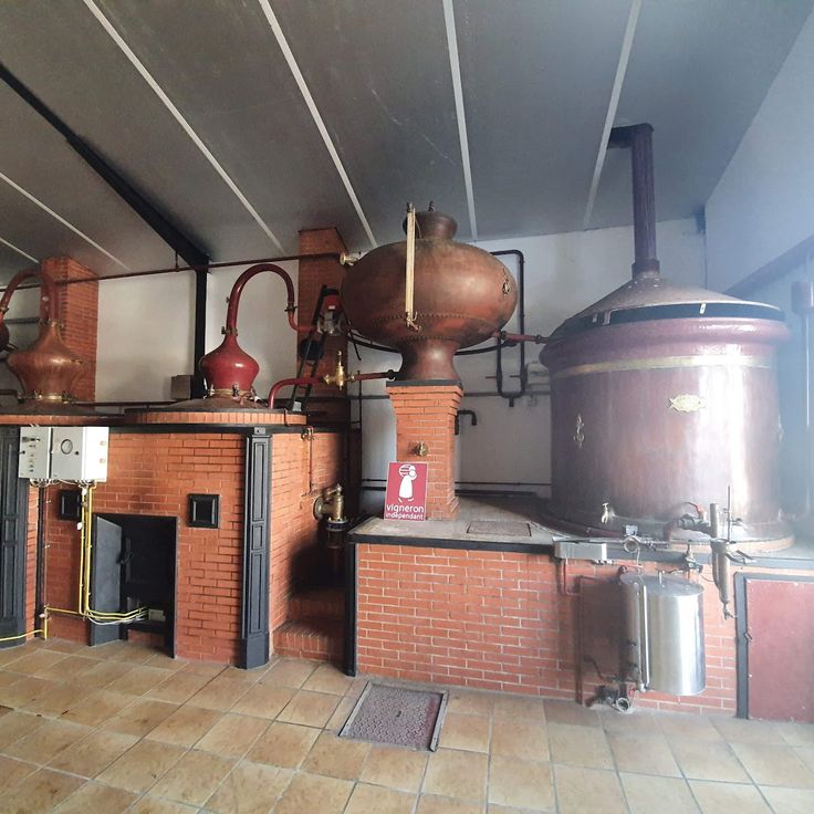
This vineyard produces red and white Pineau des Charentes using traditional methods practiced for generations across the region. The estate on Oléron invites visitors to discover local winemaking traditions and sample the fortified wine created by blending grape must with Cognac. Production follows techniques applied on the island since the nineteenth century, where the maritime climate benefits the cultivation of grape varieties. Pineau des Charentes forms part of the Charente gastronomic heritage and is enjoyed as an aperitif or accompaniment to regional specialties.
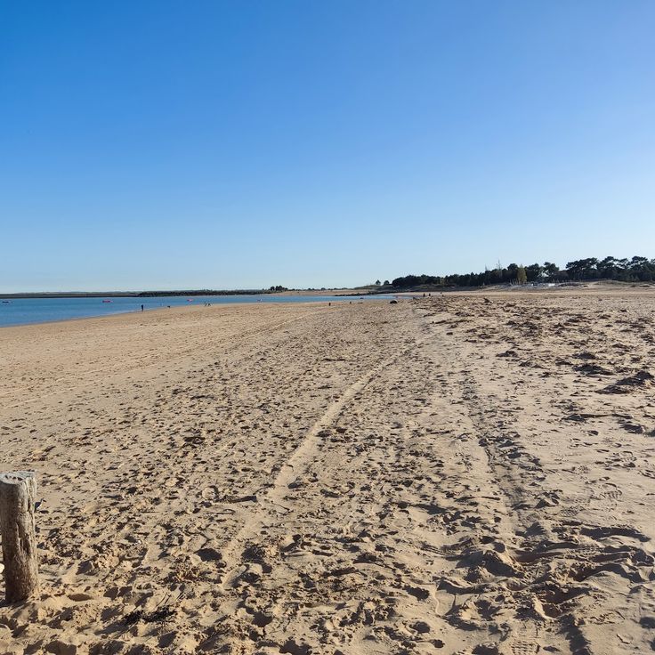
This beach runs along the eastern coast of the island and offers fine sand with access to the Atlantic. Supervised swimming areas operate during summer months. The protected eastern location makes Saumonards Beach an alternative to the more wave-exposed beaches on Oléron's western shore. The shallow waters suit families with children, while proximity to Boyardville provides dining facilities and amenities within walking distance.
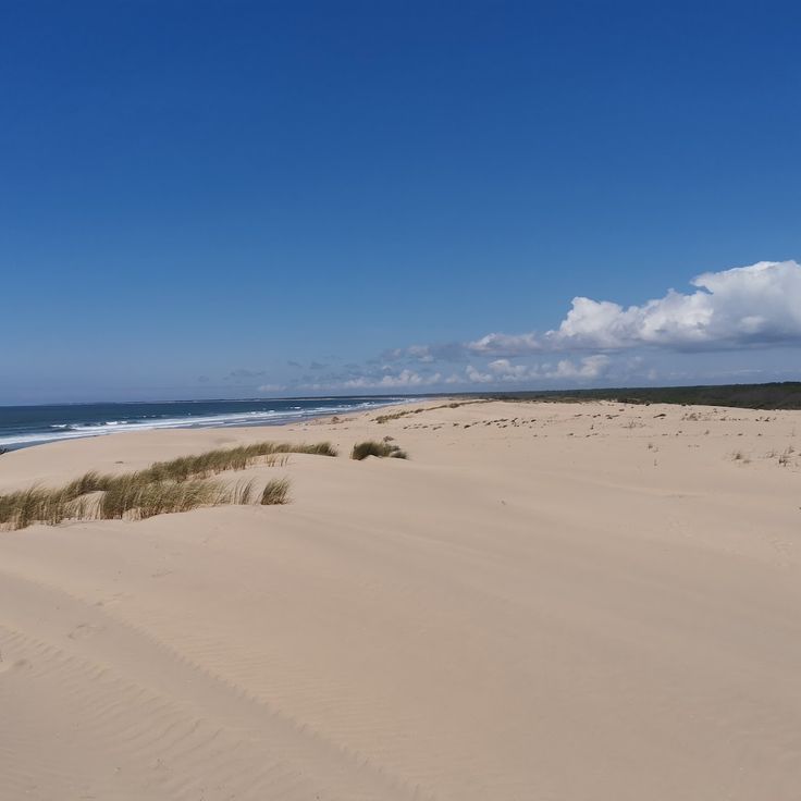
This beach is located in a protected environment and features sand dunes along with maritime vegetation, attracting families and water sports practitioners during the summer season.
This citadel was built under Louis XIV to protect the Atlantic coast and secure the passage through the Pertuis de Maumusson against enemy vessels. The fortification forms the core of the defensive system on Oléron Island and illustrates the military architecture of the 17th century. Its bastions and ramparts reflect the strategic importance the island held within the French coastal defense during the era of Vauban.
This defensive structure rises from a rocky islet off the coast of Oléron and was built in the seventeenth century under Louis XIV to protect the approaches to the Charente River. A causeway connects the fort to the mainland but floods at high tide, making access possible only at low tide or by boat. The fortification complements the military heritage of the island, which includes the Citadel of Château d'Oléron and Fort Boyard positioned offshore. Visitors can explore the ramparts, casemates, and the central building that now houses a museum.
This lighthouse rises 151 feet (46 meters) above sea level at the northern tip of Oléron Island, marking the northern entrance to the Pertuis d'Antioche, which separates the mainland from the island. Built in 1836, the structure replaced an earlier tower from the seventeenth century and has served navigation in these waters characterized by currents and shoals for nearly two centuries. The black and white striped tower contains 224 steps leading to the observation platform, from which visitors can view the western coastline of the island, the Gironde estuary to the south, and on clear days the mainland coast to the east. At the base of the lighthouse, a museum provides information on the history of beacons in the region and the evolution of navigation techniques.
Saint-Trojan-les-Bains sits at the southern tip of Oléron Island and serves as a coastal resort where visitors find sandy beaches and an extensive maritime pine forest reaching the shoreline. This section of the island provides access to several beaches along the Atlantic coast and walking trails through the forested dunes. The town functions as a starting point for excursions into the southern natural areas of the island, where pines and holm oaks shape the landscape. The beaches extend for several miles and attract both bathers and surfers.
This oval military construction rises from a sandbank between Oléron Island and Île d'Aix. Fort Boyard was built over more than three decades during the nineteenth century to control access to the Charente estuary. The structure lost its strategic purpose before completion, however, and never served its intended military function. Since the 1990s the fort has housed a television production that brought it international recognition. Visitors cannot tour the interior, but numerous boat operators offer circuits around the structure, allowing travelers to observe the architecture and its exposed position in open water between the islands.
This cluster of painted wooden cabins lines the harbor basin at Château d'Oléron, where painters, sculptors and artisans have set up studios over the past few decades. Once used by fishermen for storing nets and gear, the structures now serve as workshops and sales spaces where visitors can watch the creative process and purchase original works. The cabins form a recognizable part of the island's identity and show how historic port buildings have been repurposed for artistic use while maintaining a connection to the maritime tradition of the settlement.
This sandy beach on the east coast of the island lies sheltered from west winds and offers views of Fort Boyard offshore. Boyardville Beach occupies a calmer side of Oléron, facing away from the open Atlantic, and draws families and visitors who prefer gentler surf. The shallow water extends across a wide expanse, allowing children to play in the shallows. From here, you can make out the oval silhouette of Fort Boyard sitting on its sandbank several hundred yards offshore.
These former salt pans at the southern end of Oléron represent one of the historic production sites that shaped the island's economy for centuries. The site has been converted into an open-air museum that demonstrates traditional methods of sea salt extraction and explains the economic importance of this activity for local communities. Visitors follow a marked trail through the basins and channels, where panels detail each stage of the production process. The grounds also provide insight into the work of the paludiers who harvested salt by hand, as well as the changes this industry experienced over time.
This channel, which connects the area to the port of Château d'Oléron, is lined with colorful wooden cabins where local artists maintain their workshops and oyster farmers sell their products. The traditional maritime architecture of these structures reflects the economic history of the island, shaped for centuries by oyster farming. Visitors can walk along the waterway and observe the connection between artisan activity and maritime heritage that characterizes this part of Oléron.
This road bridge was inaugurated in 1966 and connects the island to the French mainland over a distance of 9,390 feet (2,862 meters) with no toll. The structure ended centuries of reliance on ferry connections and enabled direct access to the continental road network. The bridge facilitates travel to the fortifications, lighthouses and natural landscapes of Oléron Island, the second largest island in mainland France after Corsica. It spans the strait between Bourcefranc-le-Chapus on the mainland and the eastern coast of the island.
This fort stands on the southeastern shore of Oléron near Bourcefranc-le-Chapus. It was built in the mid-nineteenth century to defend the coastal area and later abandoned as military priorities shifted. Today the site serves as a nature reserve that combines oyster farming operations with protected habitats for native plants and animals. Visitors explore the preserved stone structures and observe wading birds that feed in the shallow waters and salt marshes surrounding the fort. The reserve offers insight into how former military installations on the island have been adapted for ecological and economic purposes.
This beach sits in the northern part of the island and draws families seeking calm waters and flat terrain. The colorful beach cabins in traditional style line the shore and provide shelter from wind and sun. The area features stretches of sand that extend widely at low tide and allow for walks along the water. Infrastructure includes parking facilities and basic amenities for visitors during the summer season.
This harbor on the western coast of Oléron Island has served as a shelter for the fishing fleet since the nineteenth century. La Cotinière was equipped with jetties and breakwaters starting in the 1850s to provide vessels with a safe port of call. Fishermen working from the harbor catch sole, sea bass and other species using longlines and pots. Each morning, boats return with the catch, which is then sold at the auction hall. Visitors can watch the trawlers arrive and walk along the quay where fish merchants prepare the goods for restaurants and markets. The quay wall provides a view of the bay and the harbor entrance, while the adjoining district houses shops and restaurants specializing in seafood.
This park on the eastern side of Oléron Island has allowed visitors to observe coypus and other waterfowl in their natural habitat for over three decades. The facility extends across several ponds where visitors can watch these South American rodents swimming and feeding. In addition to coypus, the site is home to ducks, geese, and other bird species that inhabit the freshwater areas of the island. Information panels explain the biology of these animals and their establishment in the region. The park offers an alternative to the beaches and fortifications that define Oléron's tourism landscape.
This town has served as the island's administrative center since 1852, bringing together shops, services and public facilities at a central location. The traditional market on Place Gambetta gathers vendors and producers several times a week, while commercial streets provide visitors with a practical base for supplies. A 19th-century bandstand stands in the center of the main square, illustrating the social role such structures played in community organization. The Church of Saint-Pierre, in its current form dating from the 18th century, marks the town's religious heritage.
This sandy beach on the west coast of the island offers direct views of the Atlantic Ocean and is frequently used by visitors for walking. The beach extends for several miles (several kilometers) south of Saint-Trojan-les-Bains and borders an extensive pine forest that provides natural shade and shelter from the wind. Atlantic waves and tides shape the character of this coastal stretch, popular with both swimmers and surfers. The Grande Plage forms one of the longest continuous beach sections on Oléron and connects the natural environment of the island with its maritime heritage.
This waterway is lined with colorful oyster huts where farming has continued for generations, creating a typical scene along the coast of Oléron Island. The wooden structures, painted in shades of red, blue and green, stand on pilings above the water and serve as work spaces and sales points for oyster producers. The Chenal de la Brande is one of several channels on the island where visitors observe maritime work and purchase fresh oysters directly from growers. The site demonstrates the economic role of oyster farming for Oléron and the Charente-Maritime region.
This wreck recalls the perils of Atlantic shipping and adds to the maritime heritage of Oléron Island. The Presidente Viera, a Portuguese cargo vessel, ran aground in January 1916 and has remained off the coast of Saint-Trojan-les-Bains ever since. At low tide, the metal hull becomes visible, allowing visitors to observe the remains of the ship that became part of the regional history of maritime navigation. Access is on foot from the beach when tides permit, offering a perspective on the nautical risks faced by merchant vessels during the early twentieth century.
This beach in Saint-Trojan-les-Bains lies sheltered along the southern coast of Oléron, offering families straightforward access to fine sand. The bay benefits from calmer waters than those on the western shore, making it suitable for visitors with children. Facilities such as showers and lifeguards operate during the summer season. The beach extends for several hundred yards and borders wooded areas that provide shade. The setting combines the military and maritime elements that define Oléron with the natural coastal landscapes visitors discover throughout the island.
The Chenal d'Arceau on Oléron Island is a natural waterway lined with wooden huts where oyster farmers work and cultivate their shellfish using methods passed down through generations. This waterway reflects the traditional oyster farming that has shaped the island's economy for centuries.
This harbor supports fishing and oyster farming activities that sustain the maritime economy of Oléron Island. Colored huts line the docks where fishermen and oyster farmers store equipment and carry out daily operations. The La Baudissière channel connects the harbor basin to open waters, providing access to oyster beds that stretch along the eastern shore of the island. Visitors observe boats being prepared, catches being unloaded, and facilities being maintained, all part of work that has supported the local community for generations.
This Atlantic beach on the northern part of Oléron offers fine sand and consistent waves that attract surfers of all levels, bodyboarders and kitesurfers throughout the year. The exposed position at the tip of the island generates regular swells that make this beach one of the most frequented spots for water sports on Oléron. The wide sandy area provides space for both beginners and experienced surfers, and facilities include parking areas and beach access points near the dunes.
This thalassotherapy center uses seawater and marine algae for therapeutic treatments focused on relaxation, physical recovery and health care. The facility offers a range of treatments including water massage, algae wraps and marine mud applications that draw on the mineral properties of the Atlantic. The center is located in Saint-Trojan-les-Bains at the southern tip of Oléron Island, where the combination of ocean climate and forested coastal landscape supports the therapeutic effects of the treatments. In addition to medical applications, the facility includes fitness areas and pools filled with heated seawater.
This headland marks the northern point of Oléron Island and forms the geographic boundary between the Atlantic Ocean and the waters of the Pertuis d'Antioche. The promontory extends into a shipping area where currents and shoals have shaped navigation and defensive installations for centuries. The Chassiron Lighthouse has stood here since 1836 and was raised several times to improve its range. Visitors can explore the grounds around the tower, where gardens featuring medicinal plants and maritime species have been established. From this point, views extend across the coastal sections of the island and neighboring landmasses.
This sandy beach on the Atlantic coast of Île d'Oléron attracts surfers who take advantage of the consistent waves that this location provides. The beach fits into the natural diversity of the island, where stretches of shoreline, dunes, and pine forests alternate. The exposed western coast of Oléron receives Atlantic swells directly, creating conditions suitable for both beginners and more experienced wave riders. Access follows paths that lead through wooded hinterland, and infrastructure remains limited to essentials.
The Marais aux Oiseaux extends over one hundred twenty hectares in the center of Oléron Island and provides a protected habitat for resident and migratory birds. The area includes wetlands, ponds and reed zones where several observation posts have been installed along marked trails. Visitors discover species such as herons, ducks and shorebirds that use this environment. An educational trail informs about the habitats and conservation efforts adapted to the natural conditions of this part of the island.
This brewery, founded in 2009 on Île d'Oléron, produces beer using traditional methods without chemical additives or artificial coloring agents. The name references Fort Boyard, positioned offshore on its sandbank near the island. The brewery offers visitors an opportunity to discover the craft of beer production, an activity that complements the culinary offerings of the largest island in mainland France after Corsica. The beers are produced in small batches and reflect the maritime tradition of this Atlantic region. Guided tours explain the various stages of production, and tasting sessions allow sampling of the different varieties created by this craft establishment.
This tourist train crosses the state forest and connects the center of Saint-Trojan-les-Bains with Grande Plage beach over a route of several miles through pine forests. Le P'tit Train has operated along this route for decades, providing visitors with transportation between the southern island area and the Atlantic coast. The journey passes through the wooded dune terrain that characterizes the southern section of Oléron and forms part of the larger forest area extending across this side of the island.
This museum presents collections on the island's history, maritime traditions, oyster farming, and the trades practiced here for centuries. The exhibits document the economic and cultural development of Oléron, from salt extraction through seafaring to present-day oyster production. Visitors explore tools, photographs, and objects that illustrate the daily life of island residents and demonstrate their connection to the Atlantic.
This family winery cultivates grape varieties adapted to the island's soils and produces dry white wines, light reds, and fresh rosés. The parcels are located in an area where proximity to the Atlantic influences the microclimate and salt laden air from the ocean reaches the vines. The estate offers visitors insights into growing methods and cellar techniques based on the specific conditions of this island location. Tastings allow discovery of the mineral character present in the wines produced here.
This former windmill has been restored and now houses an exhibition about milling techniques and the development of mills on Île d'Oléron. The site illustrates traditional grain processing that shaped the local economy for centuries before port facilities and salt extraction came to dominate the island. Visitors can examine the mechanics of the sails and millstones and learn how wind power was harnessed for flour production. The mill complements the island's military and maritime heritage by offering insight into the rural crafts that sustained communities across Oléron.
This beach extends for several miles along the Atlantic coast of Oléron and offers ample space with its fine sand for families during the summer season. Remigeasse Beach sits on the western side of the island and ranks among the longest coastal stretches in this area, where dunes and pine forests form the backdrop. Visitors find an open setting here for swimming and walking along the waterline, which extends over considerable distances.
This family estate produces wines on roughly seven acres (three hectares) of vineyards and offers tastings accompanied by regional products such as rillettes made from local fish. The location on Oléron Island, where maritime influences and Atlantic breezes shape the microclimate, gives the wines produced here distinctive characteristics. Visitors can tour the winery and learn about the grape varieties that thrive under the specific conditions of the island. The combination of wine tasting and regional culinary specialties provides insight into local food culture and the importance of maritime products to the island economy.
This vineyard produces red and white Pineau des Charentes using traditional methods practiced for generations across the region. The estate on Oléron invites visitors to discover local winemaking traditions and sample the fortified wine created by blending grape must with Cognac. Production follows techniques applied on the island since the nineteenth century, where the maritime climate benefits the cultivation of grape varieties. Pineau des Charentes forms part of the Charente gastronomic heritage and is enjoyed as an aperitif or accompaniment to regional specialties.
This beach runs along the eastern coast of the island and offers fine sand with access to the Atlantic. Supervised swimming areas operate during summer months. The protected eastern location makes Saumonards Beach an alternative to the more wave-exposed beaches on Oléron's western shore. The shallow waters suit families with children, while proximity to Boyardville provides dining facilities and amenities within walking distance.
This beach is located in a protected environment and features sand dunes along with maritime vegetation, attracting families and water sports practitioners during the summer season.
This citadel was built under Louis XIV to protect the Atlantic coast and secure the passage through the Pertuis de Maumusson against enemy vessels. The fortification forms the core of the defensive system on Oléron Island and illustrates the military architecture of the 17th century. Its bastions and ramparts reflect the strategic importance the island held within the French coastal defense during the era of Vauban.
This defensive structure rises from a rocky islet off the coast of Oléron and was built in the seventeenth century under Louis XIV to protect the approaches to the Charente River. A causeway connects the fort to the mainland but floods at high tide, making access possible only at low tide or by boat. The fortification complements the military heritage of the island, which includes the Citadel of Château d'Oléron and Fort Boyard positioned offshore. Visitors can explore the ramparts, casemates, and the central building that now houses a museum.
This lighthouse rises 151 feet (46 meters) above sea level at the northern tip of Oléron Island, marking the northern entrance to the Pertuis d'Antioche, which separates the mainland from the island. Built in 1836, the structure replaced an earlier tower from the seventeenth century and has served navigation in these waters characterized by currents and shoals for nearly two centuries. The black and white striped tower contains 224 steps leading to the observation platform, from which visitors can view the western coastline of the island, the Gironde estuary to the south, and on clear days the mainland coast to the east. At the base of the lighthouse, a museum provides information on the history of beacons in the region and the evolution of navigation techniques.
Saint-Trojan-les-Bains sits at the southern tip of Oléron Island and serves as a coastal resort where visitors find sandy beaches and an extensive maritime pine forest reaching the shoreline. This section of the island provides access to several beaches along the Atlantic coast and walking trails through the forested dunes. The town functions as a starting point for excursions into the southern natural areas of the island, where pines and holm oaks shape the landscape. The beaches extend for several miles and attract both bathers and surfers.
This oval military construction rises from a sandbank between Oléron Island and Île d'Aix. Fort Boyard was built over more than three decades during the nineteenth century to control access to the Charente estuary. The structure lost its strategic purpose before completion, however, and never served its intended military function. Since the 1990s the fort has housed a television production that brought it international recognition. Visitors cannot tour the interior, but numerous boat operators offer circuits around the structure, allowing travelers to observe the architecture and its exposed position in open water between the islands.
This cluster of painted wooden cabins lines the harbor basin at Château d'Oléron, where painters, sculptors and artisans have set up studios over the past few decades. Once used by fishermen for storing nets and gear, the structures now serve as workshops and sales spaces where visitors can watch the creative process and purchase original works. The cabins form a recognizable part of the island's identity and show how historic port buildings have been repurposed for artistic use while maintaining a connection to the maritime tradition of the settlement.
This sandy beach on the east coast of the island lies sheltered from west winds and offers views of Fort Boyard offshore. Boyardville Beach occupies a calmer side of Oléron, facing away from the open Atlantic, and draws families and visitors who prefer gentler surf. The shallow water extends across a wide expanse, allowing children to play in the shallows. From here, you can make out the oval silhouette of Fort Boyard sitting on its sandbank several hundred yards offshore.
These former salt pans at the southern end of Oléron represent one of the historic production sites that shaped the island's economy for centuries. The site has been converted into an open-air museum that demonstrates traditional methods of sea salt extraction and explains the economic importance of this activity for local communities. Visitors follow a marked trail through the basins and channels, where panels detail each stage of the production process. The grounds also provide insight into the work of the paludiers who harvested salt by hand, as well as the changes this industry experienced over time.
This channel, which connects the area to the port of Château d'Oléron, is lined with colorful wooden cabins where local artists maintain their workshops and oyster farmers sell their products. The traditional maritime architecture of these structures reflects the economic history of the island, shaped for centuries by oyster farming. Visitors can walk along the waterway and observe the connection between artisan activity and maritime heritage that characterizes this part of Oléron.
This road bridge was inaugurated in 1966 and connects the island to the French mainland over a distance of 9,390 feet (2,862 meters) with no toll. The structure ended centuries of reliance on ferry connections and enabled direct access to the continental road network. The bridge facilitates travel to the fortifications, lighthouses and natural landscapes of Oléron Island, the second largest island in mainland France after Corsica. It spans the strait between Bourcefranc-le-Chapus on the mainland and the eastern coast of the island.
This fort stands on the southeastern shore of Oléron near Bourcefranc-le-Chapus. It was built in the mid-nineteenth century to defend the coastal area and later abandoned as military priorities shifted. Today the site serves as a nature reserve that combines oyster farming operations with protected habitats for native plants and animals. Visitors explore the preserved stone structures and observe wading birds that feed in the shallow waters and salt marshes surrounding the fort. The reserve offers insight into how former military installations on the island have been adapted for ecological and economic purposes.
This beach sits in the northern part of the island and draws families seeking calm waters and flat terrain. The colorful beach cabins in traditional style line the shore and provide shelter from wind and sun. The area features stretches of sand that extend widely at low tide and allow for walks along the water. Infrastructure includes parking facilities and basic amenities for visitors during the summer season.
This harbor on the western coast of Oléron Island has served as a shelter for the fishing fleet since the nineteenth century. La Cotinière was equipped with jetties and breakwaters starting in the 1850s to provide vessels with a safe port of call. Fishermen working from the harbor catch sole, sea bass and other species using longlines and pots. Each morning, boats return with the catch, which is then sold at the auction hall. Visitors can watch the trawlers arrive and walk along the quay where fish merchants prepare the goods for restaurants and markets. The quay wall provides a view of the bay and the harbor entrance, while the adjoining district houses shops and restaurants specializing in seafood.
This park on the eastern side of Oléron Island has allowed visitors to observe coypus and other waterfowl in their natural habitat for over three decades. The facility extends across several ponds where visitors can watch these South American rodents swimming and feeding. In addition to coypus, the site is home to ducks, geese, and other bird species that inhabit the freshwater areas of the island. Information panels explain the biology of these animals and their establishment in the region. The park offers an alternative to the beaches and fortifications that define Oléron's tourism landscape.
This town has served as the island's administrative center since 1852, bringing together shops, services and public facilities at a central location. The traditional market on Place Gambetta gathers vendors and producers several times a week, while commercial streets provide visitors with a practical base for supplies. A 19th-century bandstand stands in the center of the main square, illustrating the social role such structures played in community organization. The Church of Saint-Pierre, in its current form dating from the 18th century, marks the town's religious heritage.
This sandy beach on the west coast of the island offers direct views of the Atlantic Ocean and is frequently used by visitors for walking. The beach extends for several miles (several kilometers) south of Saint-Trojan-les-Bains and borders an extensive pine forest that provides natural shade and shelter from the wind. Atlantic waves and tides shape the character of this coastal stretch, popular with both swimmers and surfers. The Grande Plage forms one of the longest continuous beach sections on Oléron and connects the natural environment of the island with its maritime heritage.
This waterway is lined with colorful oyster huts where farming has continued for generations, creating a typical scene along the coast of Oléron Island. The wooden structures, painted in shades of red, blue and green, stand on pilings above the water and serve as work spaces and sales points for oyster producers. The Chenal de la Brande is one of several channels on the island where visitors observe maritime work and purchase fresh oysters directly from growers. The site demonstrates the economic role of oyster farming for Oléron and the Charente-Maritime region.
This wreck recalls the perils of Atlantic shipping and adds to the maritime heritage of Oléron Island. The Presidente Viera, a Portuguese cargo vessel, ran aground in January 1916 and has remained off the coast of Saint-Trojan-les-Bains ever since. At low tide, the metal hull becomes visible, allowing visitors to observe the remains of the ship that became part of the regional history of maritime navigation. Access is on foot from the beach when tides permit, offering a perspective on the nautical risks faced by merchant vessels during the early twentieth century.
This beach in Saint-Trojan-les-Bains lies sheltered along the southern coast of Oléron, offering families straightforward access to fine sand. The bay benefits from calmer waters than those on the western shore, making it suitable for visitors with children. Facilities such as showers and lifeguards operate during the summer season. The beach extends for several hundred yards and borders wooded areas that provide shade. The setting combines the military and maritime elements that define Oléron with the natural coastal landscapes visitors discover throughout the island.
The Chenal d'Arceau on Oléron Island is a natural waterway lined with wooden huts where oyster farmers work and cultivate their shellfish using methods passed down through generations. This waterway reflects the traditional oyster farming that has shaped the island's economy for centuries.
This harbor supports fishing and oyster farming activities that sustain the maritime economy of Oléron Island. Colored huts line the docks where fishermen and oyster farmers store equipment and carry out daily operations. The La Baudissière channel connects the harbor basin to open waters, providing access to oyster beds that stretch along the eastern shore of the island. Visitors observe boats being prepared, catches being unloaded, and facilities being maintained, all part of work that has supported the local community for generations.
This Atlantic beach on the northern part of Oléron offers fine sand and consistent waves that attract surfers of all levels, bodyboarders and kitesurfers throughout the year. The exposed position at the tip of the island generates regular swells that make this beach one of the most frequented spots for water sports on Oléron. The wide sandy area provides space for both beginners and experienced surfers, and facilities include parking areas and beach access points near the dunes.
This thalassotherapy center uses seawater and marine algae for therapeutic treatments focused on relaxation, physical recovery and health care. The facility offers a range of treatments including water massage, algae wraps and marine mud applications that draw on the mineral properties of the Atlantic. The center is located in Saint-Trojan-les-Bains at the southern tip of Oléron Island, where the combination of ocean climate and forested coastal landscape supports the therapeutic effects of the treatments. In addition to medical applications, the facility includes fitness areas and pools filled with heated seawater.
This headland marks the northern point of Oléron Island and forms the geographic boundary between the Atlantic Ocean and the waters of the Pertuis d'Antioche. The promontory extends into a shipping area where currents and shoals have shaped navigation and defensive installations for centuries. The Chassiron Lighthouse has stood here since 1836 and was raised several times to improve its range. Visitors can explore the grounds around the tower, where gardens featuring medicinal plants and maritime species have been established. From this point, views extend across the coastal sections of the island and neighboring landmasses.
This sandy beach on the Atlantic coast of Île d'Oléron attracts surfers who take advantage of the consistent waves that this location provides. The beach fits into the natural diversity of the island, where stretches of shoreline, dunes, and pine forests alternate. The exposed western coast of Oléron receives Atlantic swells directly, creating conditions suitable for both beginners and more experienced wave riders. Access follows paths that lead through wooded hinterland, and infrastructure remains limited to essentials.
The Marais aux Oiseaux extends over one hundred twenty hectares in the center of Oléron Island and provides a protected habitat for resident and migratory birds. The area includes wetlands, ponds and reed zones where several observation posts have been installed along marked trails. Visitors discover species such as herons, ducks and shorebirds that use this environment. An educational trail informs about the habitats and conservation efforts adapted to the natural conditions of this part of the island.
This brewery, founded in 2009 on Île d'Oléron, produces beer using traditional methods without chemical additives or artificial coloring agents. The name references Fort Boyard, positioned offshore on its sandbank near the island. The brewery offers visitors an opportunity to discover the craft of beer production, an activity that complements the culinary offerings of the largest island in mainland France after Corsica. The beers are produced in small batches and reflect the maritime tradition of this Atlantic region. Guided tours explain the various stages of production, and tasting sessions allow sampling of the different varieties created by this craft establishment.
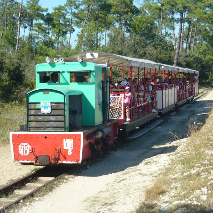
This tourist train crosses the state forest and connects the center of Saint-Trojan-les-Bains with Grande Plage beach over a route of several miles through pine forests. Le P'tit Train has operated along this route for decades, providing visitors with transportation between the southern island area and the Atlantic coast. The journey passes through the wooded dune terrain that characterizes the southern section of Oléron and forms part of the larger forest area extending across this side of the island.
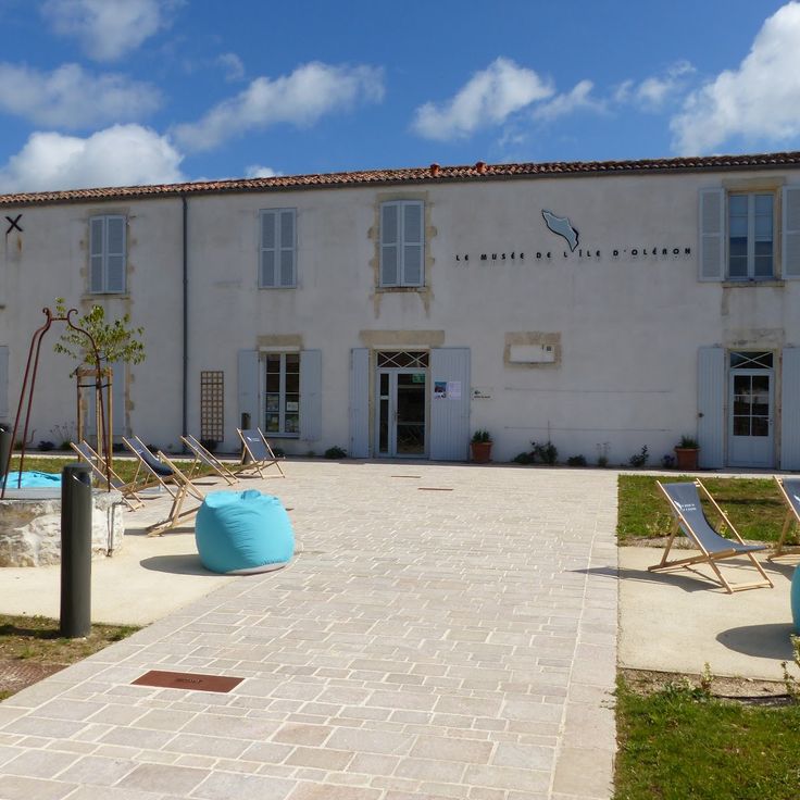
This museum presents collections on the island's history, maritime traditions, oyster farming, and the trades practiced here for centuries. The exhibits document the economic and cultural development of Oléron, from salt extraction through seafaring to present-day oyster production. Visitors explore tools, photographs, and objects that illustrate the daily life of island residents and demonstrate their connection to the Atlantic.
This family winery cultivates grape varieties adapted to the island's soils and produces dry white wines, light reds, and fresh rosés. The parcels are located in an area where proximity to the Atlantic influences the microclimate and salt laden air from the ocean reaches the vines. The estate offers visitors insights into growing methods and cellar techniques based on the specific conditions of this island location. Tastings allow discovery of the mineral character present in the wines produced here.
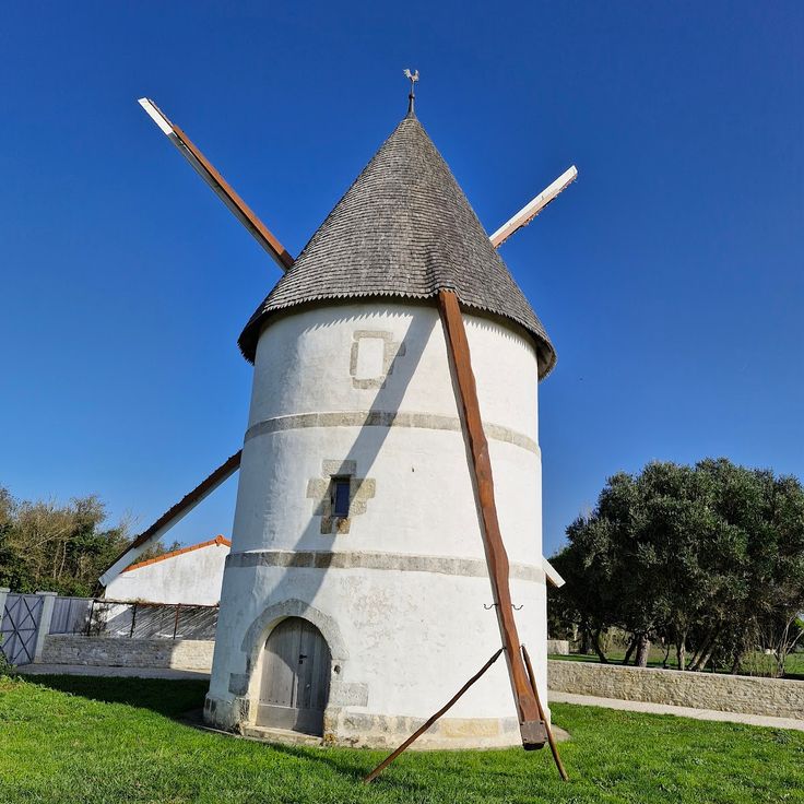
This former windmill has been restored and now houses an exhibition about milling techniques and the development of mills on Île d'Oléron. The site illustrates traditional grain processing that shaped the local economy for centuries before port facilities and salt extraction came to dominate the island. Visitors can examine the mechanics of the sails and millstones and learn how wind power was harnessed for flour production. The mill complements the island's military and maritime heritage by offering insight into the rural crafts that sustained communities across Oléron.
This beach extends for several miles along the Atlantic coast of Oléron and offers ample space with its fine sand for families during the summer season. Remigeasse Beach sits on the western side of the island and ranks among the longest coastal stretches in this area, where dunes and pine forests form the backdrop. Visitors find an open setting here for swimming and walking along the waterline, which extends over considerable distances.
This family estate produces wines on roughly seven acres (three hectares) of vineyards and offers tastings accompanied by regional products such as rillettes made from local fish. The location on Oléron Island, where maritime influences and Atlantic breezes shape the microclimate, gives the wines produced here distinctive characteristics. Visitors can tour the winery and learn about the grape varieties that thrive under the specific conditions of the island. The combination of wine tasting and regional culinary specialties provides insight into local food culture and the importance of maritime products to the island economy.
This vineyard produces red and white Pineau des Charentes using traditional methods practiced for generations across the region. The estate on Oléron invites visitors to discover local winemaking traditions and sample the fortified wine created by blending grape must with Cognac. Production follows techniques applied on the island since the nineteenth century, where the maritime climate benefits the cultivation of grape varieties. Pineau des Charentes forms part of the Charente gastronomic heritage and is enjoyed as an aperitif or accompaniment to regional specialties.
This beach runs along the eastern coast of the island and offers fine sand with access to the Atlantic. Supervised swimming areas operate during summer months. The protected eastern location makes Saumonards Beach an alternative to the more wave-exposed beaches on Oléron's western shore. The shallow waters suit families with children, while proximity to Boyardville provides dining facilities and amenities within walking distance.
This beach is located in a protected environment and features sand dunes along with maritime vegetation, attracting families and water sports practitioners during the summer season.