Chest opened
+${chestReward.xp} XP
Explorer
NOUVEAU ×${chestReward.collectible.quantity}
tapez pour fermer
Chest locked

Open chests in the app

Around Us is built for your phone — chests unlock when you walk, explore and capture nearby places.

Enable Location

We need your location to show you interesting places around you

Discover nearby places

Find interesting locations and hidden gems around you

Precise directions

Get accurate directions and distances to places

Your location is never shared with other users. It's only used when you tap the location button.

Greenbrier River

Log in to your account

Start exploring — it's free

Trusted by 72,887 travelers worldwide

Continue with Google
Continue with Apple
or

We will send you a code to connect

By continuing, you accept our Terms and Conditions and our Privacy Policy

Check your inbox

We've sent a pincode in your inbox. Please enter the code below.

Greenbrier River
Discussion Reviews 1 Photos
10.4k Popularity

Greenbrier River, River in southeastern West Virginia, United States.

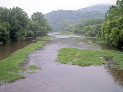
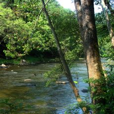
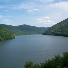
The Greenbrier River is a river in southern West Virginia that winds through forested mountain valleys before joining the New River. It passes through several counties and remains undammed along most of its course.

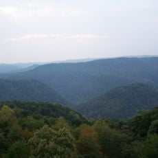
European settlers began moving into the Greenbrier valley in the early 1700s, using the river as a natural corridor through the Appalachian mountains. A railway line later followed the river, linking isolated valleys to the rest of the state.

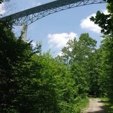
Along the Greenbrier River, an old rail corridor has been turned into a trail that connects small communities along the banks. Walking or cycling it gives a sense of how closely daily life in this part of West Virginia has always been tied to the water.

The river is accessible for paddling at several points, with spring offering higher water and summer generally providing calmer stretches. Checking water levels ahead of your visit and identifying put-in spots along the banks will help you plan a safe outing.

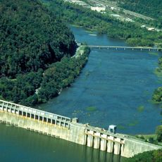
The Greenbrier River is one of the longest rivers in the eastern United States that flows without any dams along its length. This uninterrupted flow has allowed rare freshwater mussel species to survive in its waters, species that have disappeared from most other rivers in the region.

The community of curious travelers

AroundUs brings together thousands of curated places, local tips, and hidden gems, enriched daily by 60,000 contributors worldwide.

Start exploring
Location
GPS coordinates
37.65360,-80.88470
Latest update
March 3, 2026 08:21
Around this place
Pipestem Resort State Park
United States of America

Pipestem Resort State Park

16.6 km
Bluestone Lake
United States of America

Bluestone Lake

1.5 km
Phil G. McDonald Bridge
United States of America

Phil G. McDonald Bridge

18.8 km
Bluestone National Scenic River
United States of America

Bluestone National Scenic River

16 km
Bluestone State Park
United States of America

Bluestone State Park

6.2 km
Little Beaver State Park
United States of America

Little Beaver State Park

20.7 km
Camp Creek State Park
United States of America

Camp Creek State Park

27.4 km
St. Colman's Roman Catholic Church and Cemetery
United States of America

St. Colman's Roman Catholic Church and Cemetery

12.9 km
Col. James Graham House
United States of America

Col. James Graham House

13.5 km
Blue Sulphur Springs Pavilion
United States of America

Blue Sulphur Springs Pavilion

28.9 km
Indian Creek Covered Bridge
United States of America

Indian Creek Covered Bridge

29.7 km
Alexander McVeigh Miller House
United States of America

Alexander McVeigh Miller House

23.7 km
Summers County Courthouse
United States of America

Summers County Courthouse

2.2 km
Salt Sulphur Springs Historic District
United States of America

Salt Sulphur Springs Historic District

29.3 km
Laurel Creek Covered Bridge
United States of America

Laurel Creek Covered Bridge

25 km
Cook's Mill
United States of America

Cook's Mill

21.2 km
Hinton Historic District
United States of America

Hinton Historic District

2.2 km
Wildwood
United States of America

Wildwood

29.6 km
Alderson Bridge
United States of America

Alderson Bridge

22.7 km
Alderson Historic District
United States of America

Alderson Historic District

22.8 km
Pence Springs Hotel Historic District
United States of America

Pence Springs Hotel Historic District

15 km
Jordan's Chapel
United States of America

Jordan's Chapel

13.7 km
Wallace Estill, Sr., House
United States of America

Wallace Estill, Sr., House

26.7 km
Prince Brothers General Store
United States of America

Prince Brothers General Store

27.5 km
McNeer House
United States of America

McNeer House

29.4 km
Trump-Lilly Farmstead
United States of America

Trump-Lilly Farmstead

5.2 km
Sunset Hill
United States of America

Sunset Hill

22.6 km
Argabrite House
United States of America

Argabrite House

23.5 km
Show the full map
Reviews
Share your experience

No review yet

Discussions
Start a discussion...

No discussion yet

« Greenbrier River - River in southeastern West Virginia, United States » is provided by Around Us (aroundus.com). Images and texts are derived from Wikimedia project under a Creative Commons license. You are allowed to copy, distribute, and modify copies of this page, under the conditions set by the license, as long as this note is clearly visible.

Discover hidden gems everywhere you go!

From secret cafés to breathtaking viewpoints, skip the crowded tourist spots and find places that match your style. Our app makes it easy with voice search, smart filtering, route optimization, and insider tips from travelers worldwide. Download now for the complete mobile experience.

Around Us App Screenshot

A unique approach to discovering new places

Le Figaro

All the places worth exploring

France Info

A tailor-made excursion in just a few clicks

20 Minutes

Around Us
Travel Guide & Maps
Download

Send to your phone

QR Code
1

Open the camera app on your mobile.

2

Point at the QR code with your camera. A notification will appear.

3

Tap the notification to open the link.