Nilometer in Rhoda Island
Nilometer in Rhoda Island, Ancient water measurement structure in Rhoda Island, Egypt.
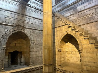
The Nilometer on Rhoda Island is an ancient water measurement structure featuring an octagonal marble column inside a stone well that changes from a rectangular top to a circular base. Carved marks on the marble column inside form a graduated scale that allowed officials to track precise water level changes.
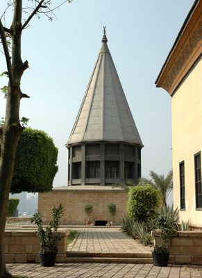
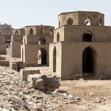
This structure was built in 861 AD under caliph Al-Mutawakkil to predict annual Nile floods and determine taxation levels for landowners and farmers. A cone-shaped dome was added much later in 1925 as the structure underwent restoration and adaptation to modern times.
The walls display Quranic inscriptions that connect water, mathematics, and prosperity, showcasing one of Egypt's oldest examples of Kufic script. These writings show how deeply the Nile, religious faith, and daily survival were intertwined for the people of that era.
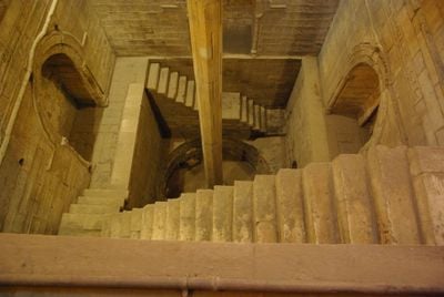
You can step into the internal chamber to view the measurement system up close, which is marked by carved lines on the marble column. The space inside is quite narrow and dim, so it helps to bring a flashlight or allow your eyes to adjust to the low light.
The structure blends three distinct architectural styles beneath its surface: a medieval well, classical measurement tools, and a 20th-century cone-shaped dome. This layering of construction methods from different eras reveals how engineering approaches to water management evolved across Egyptian history.
Location: Rhoda Island
Inception: 861
Address: Al-Miqyas Street, Southern Tip of Al-Roda Island, Cairo Governorate شارع المقياس, 264G+Q2J, الطرف الجنوبي, لجزيرة الروضة, قسم مصر القديمة، محافظة القاهرة 4240101, Egypt
Opening Hours: Monday-Sunday 09:00-15:45
Website: https://egymonuments.gov.eg/ar/monuments/rawda-island-nilometer
GPS coordinates: 30.00690,31.22501
Latest update: December 6, 2025 16:04
Cairo is home to millennia of history. The Giza Pyramids, built between 2686 and 2494 BC, stand alongside Fatimid mosques like the Ibn Tulun Mosque from 879, and Mamluk fortifications such as Saladin's Citadel from the 12th century. Religious heritage reflects community diversity: Saint Serge Church...
Al-Fustat
1.2 km
Giza Zoo
2.2 km
Hanging Church
516 m
Cairo Geniza
592 m
Manial Palace and Museum
2.3 km
National Museum of Egyptian Civilization
2.2 km
Coptic Cairo
658 m
National Museum of Egyptian Civilisation
2.2 km
Ben Ezra Synagogue
592 m
Pharaonic Village
1.4 km
Coptic Museum
556 m
Manasterly Palace
55 m
Church of St. George
602 m
Egyptian Geological Museum
1.2 km
Saints Sergius and Bacchus Church
547 m
Mohamed Ali Palace
2.3 km
Ahmed Shawki Museum
1.8 km
Saint Mercurius Church in Coptic Cairo
1.2 km
Church of Saint Menas
644 m
Umm Kulthum Museum
81 m
Sultan Qaytbay Roda Mosque
1.9 km
Powder magazine of Muhammad Ali
2.3 km
Qubbas of the seven daughters
2.3 km
German Cemetery, Cairo
1.1 km
Zoological Museum
1.8 km
Cairo War Memorial Cemetery
999 m
Salah ad-Din mosque
2.4 km
Fustat ruins
1.3 kmVisited this place? Tap the stars to rate it and share your experience / photos with the community! Try now! You can cancel it anytime.
Discover hidden gems everywhere you go!
From secret cafés to breathtaking viewpoints, skip the crowded tourist spots and find places that match your style. Our app makes it easy with voice search, smart filtering, route optimization, and insider tips from travelers worldwide. Download now for the complete mobile experience.
A unique approach to discovering new places❞
— Le Figaro
All the places worth exploring❞
— France Info
A tailor-made excursion in just a few clicks❞
— 20 Minutes