Golden Eagle Trail

Log in to your account

AroundUs is a community-driven map of interesting places, built by curious explorers like you. It grows with every review, story, and photo you share.
Connect to save your favorite spots, contribute locations, and create personalized routes.
Continue with Google
Continue with Apple
Continue with X
Continue with Facebook
Continue with email
By continuing, you accept our Terms and Conditions and our Privacy Policy
Create an account
Add to collection
Map
Suggest a change
Share

Golden Eagle Trail, Hiking trail in Lycoming County, US.

The Golden Eagle Trail is a 9.2 mile hiking route through varied landscapes with steep climbs and descents featuring 2,095 feet of elevation gain. The path includes multiple stream crossings and offers parking areas near the trailhead entrance.

The trail developed as part of Pennsylvania's outdoor recreation infrastructure, designed to connect natural landmarks across the region's wilderness. The network in Lycoming County was created to make the area's existing wild spaces more accessible.

Local hiking groups regularly meet here to explore nature together and share knowledge about regional plants and animals. The trail serves as a gathering point that connects outdoor enthusiasts from across the area.

The path is marked with orange blazes, making it easy to follow the route throughout your walk. Sturdy footwear and plenty of water are important, especially given the stream crossings and steep sections along the way.

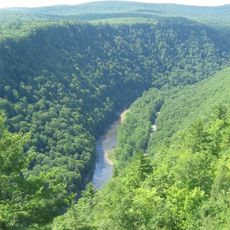
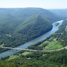
The route culminates at Raven's Horn, a summit offering broad views across Pine Creek Valley below. This high point is home to several bird species that can be spotted in their natural surroundings.

Location: Lycoming County

GPS coordinates: 41.43823,-77.51029

Latest update: December 14, 2025 09:44

Photos
Around this place
Pine Creek Gorge
United States of America

Pine Creek Gorge

24.1 km
Upper Pine Bottom State Park
United States of America

Upper Pine Bottom State Park

15.2 km
Colton Point State Park
United States of America

Colton Point State Park

29.5 km
Leonard Harrison State Park
United States of America

Leonard Harrison State Park

29.1 km
Hyner View State Park
United States of America

Hyner View State Park

15.6 km
Cogan House Covered Bridge
United States of America

Cogan House Covered Bridge

26.2 km
Ole Bull State Park
United States of America

Ole Bull State Park

20.1 km
Black Forest Trail
United States of America

Black Forest Trail

7.9 km
Sproul State Forest
United States of America

Sproul State Forest

23.5 km
Kettle Creek State Park
United States of America

Kettle Creek State Park

35.3 km
Little Pine State Park
United States of America

Little Pine State Park

15.8 km
Hammersley Wild Area
United States of America

Hammersley Wild Area

31.9 km
Hyner Run State Park
United States of America

Hyner Run State Park

13.5 km
Piper Aviation Museum
United States of America

Piper Aviation Museum

34.6 km
Forrest H. Duttlinger Natural Area
United States of America

Forrest H. Duttlinger Natural Area

30.9 km
Buttonwood Covered Bridge
United States of America

Buttonwood Covered Bridge

32.7 km
English Center Suspension Bridge
United States of America

English Center Suspension Bridge

18.5 km
Heisey House
United States of America

Heisey House

34 km
Water Street District
United States of America

Water Street District

33.8 km
Bridge in Brown Township
United States of America

Bridge in Brown Township

5.5 km
Isaac A. Packer Farm
United States of America

Isaac A. Packer Farm

30.5 km
Farrandsville Iron Furnace
United States of America

Farrandsville Iron Furnace

29.3 km
Bridge in Porter Township
United States of America

Bridge in Porter Township

34.6 km
Colton Point State Park Historic District
United States of America

Colton Point State Park Historic District

29.6 km
Jersey Shore Historic District
United States of America

Jersey Shore Historic District

33.9 km
Jay Street Bridge
United States of America

Jay Street Bridge

33.8 km
Roxy Theatre
United States of America

Roxy Theatre

34 km
Jersey Shore
United States of America

Jersey Shore

33 km
Show the full map
Reviews

Visited this place? Tap the stars to rate it and share your experience / photos with the community! Try now! You can cancel it anytime.

« Golden Eagle Trail - Hiking trail in Lycoming County, US » is provided by Around Us (aroundus.com). Images and texts are derived from Wikimedia project under a Creative Commons license. You are allowed to copy, distribute, and modify copies of this page, under the conditions set by the license, as long as this note is clearly visible.

Discover hidden gems everywhere you go!

From secret cafés to breathtaking viewpoints, skip the crowded tourist spots and find places that match your style. Our app makes it easy with voice search, smart filtering, route optimization, and insider tips from travelers worldwide. Download now for the complete mobile experience.

Around Us App Screenshot

A unique approach to discovering new places

Le Figaro

All the places worth exploring

France Info

A tailor-made excursion in just a few clicks

20 Minutes