Enable Location

We need your location to show you interesting places around you

Discover nearby places

Find interesting locations and hidden gems around you

Precise directions

Get accurate directions and distances to places

Your location is never shared with other users. It's only used when you tap the location button.

Turtle Creek High School

Log in to your account

Start exploring — it's free

Trusted by 62,449 travelers worldwide

Continue with Google
Continue with Apple
or

We will send you a code to connect

By continuing, you accept our Terms and Conditions and our Privacy Policy

Check your inbox

We've sent a pincode in your inbox. Please enter the code below.

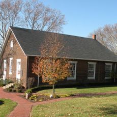
Turtle Creek High School, high school in Pennsylvania, United States

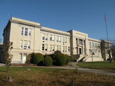
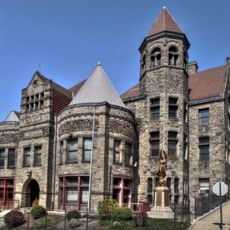
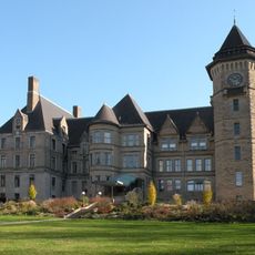
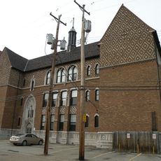
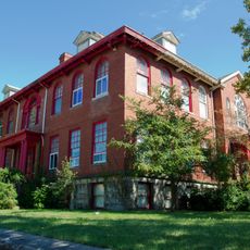
Turtle Creek High School is a high school building constructed in 1917 using neoclassical design with cream-colored bricks accented by stone and terra cotta details. Architect George Henry Schwan created the structure with clean lines and symmetrical shapes that convey strength and order.

The building opened in 1917 during World War I as Union High School serving students from multiple surrounding communities. When nearby towns established their own schools, it was renamed Turtle Creek High School and later became part of the Woodland Hills School District during the 1980s.

The building originally served high school students from multiple communities, including Turtle Creek, Wilmerding, and East Pittsburgh. Its large front lawn functions as a gathering space and remains the only substantial green area in Turtle Creek.

The building is located at 126 Monroeville Avenue in Turtle Creek near Pittsburgh and is easily accessible on foot. Today it houses Woodland Hills Academy, which serves students from kindergarten through eighth grade.

During the Great Depression, the building served dual purposes with Westinghouse workers training there at night and women earning money using sewing machines in its spaces. After closing as a regular high school, former residents and students rallied to save it, leading to its 2007 National Register of Historic Places designation.

The community of curious travelers

AroundUs brings together thousands of curated places, local tips, and hidden gems, enriched daily by 60,000 contributors worldwide.

Start exploring
Location
Architectural style
Neoclassical architecture
GPS coordinates
40.40500,-79.82389
Latest update
February 9, 2026 07:46
Around this place
Kennywood
United States of America

Kennywood

3.9 km
Steel Curtain
United States of America

Steel Curtain

3.7 km
Phantom's Revenge
United States of America

Phantom's Revenge

4 km
Carrie Furnace
United States of America

Carrie Furnace

5.7 km
Sri Venkateswara Temple
United States of America

Sri Venkateswara Temple

4.3 km
Thunderbolt
United States of America

Thunderbolt

3.9 km
Jack Rabbit
United States of America

Jack Rabbit

3.9 km
Sky Rocket
United States of America

Sky Rocket

4 km
Racer
United States of America

Racer

3.8 km
Exterminator
United States of America

Exterminator

4.1 km
George Westinghouse Bridge
United States of America

George Westinghouse Bridge

1.7 km
Carnegie Free Library of Braddock
United States of America

Carnegie Free Library of Braddock

3.5 km
Westinghouse Air Brake Company General Office Building
United States of America

Westinghouse Air Brake Company General Office Building

2 km
Braddock Locks & Dam
United States of America

Braddock Locks & Dam

3.3 km
Carrie Furnace Hot Metal Bridge
United States of America

Carrie Furnace Hot Metal Bridge

5.3 km
Pinkerton's Landing Bridge
United States of America

Pinkerton's Landing Bridge

6.3 km
Trundle Manor
United States of America

Trundle Manor

5.2 km
Rankin Bridge
United States of America

Rankin Bridge

4.8 km
Beulah Presbyterian Church
United States of America

Beulah Presbyterian Church

5.1 km
Gardner-Bailey House
United States of America

Gardner-Bailey House

6.1 km
McKeesport Connecting Railroad Bridge
United States of America

McKeesport Connecting Railroad Bridge

5.7 km
McKeesport-Duquesne Bridge
United States of America

McKeesport-Duquesne Bridge

5.5 km
PRR Port Perry Bridge
United States of America

PRR Port Perry Bridge

3.1 km
St. Colman's Catholic School
United States of America

St. Colman's Catholic School

353 m
Longfellow School
United States of America

Longfellow School

6.1 km
Bowman Homestead
United States of America

Bowman Homestead

3.8 km
Union Railroad Port Perry Bridge
United States of America

Union Railroad Port Perry Bridge

3.1 km
The Living Dead Museum & Gift Shop
United States of America

The Living Dead Museum & Gift Shop

3.5 km
Show the full map
« Turtle Creek High School - high school in Pennsylvania, United States » is provided by Around Us (aroundus.com). Images and texts are derived from Wikimedia project under a Creative Commons license. You are allowed to copy, distribute, and modify copies of this page, under the conditions set by the license, as long as this note is clearly visible.

Discover hidden gems everywhere you go!

From secret cafés to breathtaking viewpoints, skip the crowded tourist spots and find places that match your style. Our app makes it easy with voice search, smart filtering, route optimization, and insider tips from travelers worldwide. Download now for the complete mobile experience.

Around Us App Screenshot

A unique approach to discovering new places

Le Figaro

All the places worth exploring

France Info

A tailor-made excursion in just a few clicks

20 Minutes

Around Us
Travel Guide & Maps
Download

Send to your phone

QR Code
1

Open the camera app on your mobile.

2

Point at the QR code with your camera. A notification will appear.

3

Tap the notification to open the link.