Enable Location

We need your location to show you interesting places around you

Discover nearby places

Find interesting locations and hidden gems around you

Precise directions

Get accurate directions and distances to places

Your location is never shared with other users. It's only used when you tap the location button.

Millstone Bluff

Log in to your account

Start exploring — it's free

Trusted by 62,178 travelers worldwide

Continue with Google
Continue with Apple
or

We will send you a code to connect

By continuing, you accept our Terms and Conditions and our Privacy Policy

Check your inbox

We've sent a pincode in your inbox. Please enter the code below.

Millstone Bluff, mountain in United States of America

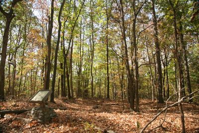
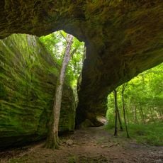
Millstone Bluff is a sandstone ridge in Pope County, Illinois that rises as a flat-topped plateau above the surrounding forest. The top of the formation shows shallow depressions where dwellings once stood, stone-lined graves carved into bedrock, and petroglyphs etched into the rock face featuring animal tracks and geometric designs.

The site was an active settlement from roughly 1350 to 1550 where Mississippian peoples built semi-subterranean homes with wooden frames and clay coverings. The community was later abandoned, possibly due to changes in climate, resource availability, or political circumstances in the region.

The site served as a gathering place where communities came together to share beliefs and practices over many centuries. The petroglyphs carved into the rock face show animal tracks, crosses, and other symbols that reflect the spiritual connection these people had to the land and sky.

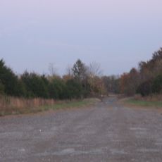
The trail is roughly three-quarters of a mile long and climbs gradually along the ridge with clear markings for easy navigation. Visitors should wear sturdy shoes due to roots and rocks, bring plenty of water and sun protection, and arrive early in the day since the site offers no water or shade.

Early American settlers quarried the bluff for millstones, removing sandstone blocks that left behind the rough surfaces still visible today and giving the place its name. This practical exploitation of the stone layer shows how the same site served different purposes across different periods of history.

The community of curious travelers

AroundUs brings together thousands of curated places, local tips, and hidden gems, enriched daily by 60,000 contributors worldwide.

Start exploring
Location
GPS coordinates
37.46944,-88.68972
Latest update
February 7, 2026 11:40
Around this place
Garden of the Gods Wilderness
United States of America

Garden of the Gods Wilderness

30.2 km
United States of America

Honeywell Uranium Hexafluoride Processing Facility

33.7 km
Ferne Clyffe State Park
United States of America

Ferne Clyffe State Park

26.7 km
Dixon Springs State Park
United States of America

Dixon Springs State Park

9.9 km
Cache River State Natural Area
United States of America

Cache River State Natural Area

26.4 km
Illinois Iron Furnace
United States of America

Illinois Iron Furnace

32.1 km
Mermet Lake State Fish and Wildlife Area
United States of America

Mermet Lake State Fish and Wildlife Area

27.1 km
Heron Pond – Little Black Slough Nature Preserve
United States of America

Heron Pond – Little Black Slough Nature Preserve

25.7 km
Mantle Rock Archeological District
United States of America

Mantle Rock Archeological District

26.5 km
Orr-Herl Mound and Village Site
United States of America

Orr-Herl Mound and Village Site

32.2 km
Vienna Public Library
United States of America

Vienna Public Library

19 km
Carrier Mills Archaeological District
United States of America

Carrier Mills Archaeological District

21.9 km
Elijah P. Curtis House
United States of America

Elijah P. Curtis House

35.7 km
Golconda Historic District
United States of America

Golconda Historic District

21.3 km
United States of America

Lusk's Ferry, Illinois

21.6 km
Saline County Poor Farm
United States of America

Saline County Poor Farm

30.3 km
Bell Smith Springs
United States of America

Bell Smith Springs

6.2 km
Willis Allen House
United States of America

Willis Allen House

35.5 km
Lusk Creek Canyon
United States of America

Lusk Creek Canyon

14.3 km
John Bridges Tavern and Store Site
United States of America

John Bridges Tavern and Store Site

29 km
Johnson County Courthouse
United States of America

Johnson County Courthouse

19.3 km
Saline County Courthouse
United States of America

Saline County Courthouse

32.8 km
Hardin County Courthouse
United States of America

Hardin County Courthouse

34.1 km
Williamson County Courthouse
United States of America

Williamson County Courthouse

36.1 km
Harrisburg City Hall
United States of America

Harrisburg City Hall

32.9 km
Massac Theatre
United States of America

Massac Theatre

35.6 km
Superman statue
United States of America

Superman statue

35.5 km
Raum Lookout Tower
United States of America

Raum Lookout Tower

15.6 km
Show the full map
« Millstone Bluff - mountain in United States of America » is provided by Around Us (aroundus.com). Images and texts are derived from Wikimedia project under a Creative Commons license. You are allowed to copy, distribute, and modify copies of this page, under the conditions set by the license, as long as this note is clearly visible.

Discover hidden gems everywhere you go!

From secret cafés to breathtaking viewpoints, skip the crowded tourist spots and find places that match your style. Our app makes it easy with voice search, smart filtering, route optimization, and insider tips from travelers worldwide. Download now for the complete mobile experience.

Around Us App Screenshot

A unique approach to discovering new places

Le Figaro

All the places worth exploring

France Info

A tailor-made excursion in just a few clicks

20 Minutes

Around Us
Travel Guide & Maps
Download

Send to your phone

QR Code
1

Open the camera app on your mobile.

2

Point at the QR code with your camera. A notification will appear.

3

Tap the notification to open the link.