Enable Location

We need your location to show you interesting places around you

Discover nearby places

Find interesting locations and hidden gems around you

Precise directions

Get accurate directions and distances to places

Your location is never shared with other users. It's only used when you tap the location button.

Log in to your account

Start exploring — it's free

Trusted by 62,932 travelers worldwide

Continue with Google
Continue with Apple
or

We will send you a code to connect

By continuing, you accept our Terms and Conditions and our Privacy Policy

Check your inbox

We've sent a pincode in your inbox. Please enter the code below.

O Kun de Kun Falls
Discussion Reviews Photo
1.5k Popularity

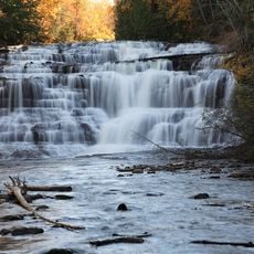
O Kun de Kun Falls, Waterfall in Ontonagon County, Michigan, United States.

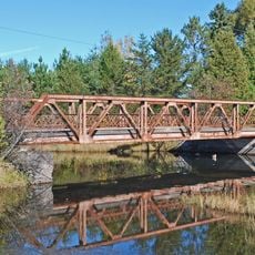
O Kun de Kun Falls consists of multiple cascades along the Baltimore River, crossed by a suspension bridge downstream from the main drop. The water tumbles through several sections, creating different views depending on where visitors stand along the waterway.

The waterfall takes its name from a Chippewa leader who lived in the Ontonagon area. This location has been a natural landmark within the region's landscape for generations.

The name comes from a local Chippewa leader whose memory remains connected to this area. Visitors walking here become part of a landscape shaped by both natural forces and indigenous heritage.

The trail starts from a parking area north of Bruce Crossing and moves through forest to reach the falls. Visitors should wear sturdy shoes and be ready for typical woodland path conditions.

A suspension bridge allows visitors to view the falls from multiple positions and discover an upper section of cascades. This vantage point reveals how the water flows through different levels, showing more than what is visible from the main trail.

The community of curious travelers

AroundUs brings together thousands of curated places, local tips, and hidden gems, enriched daily by 60,000 contributors worldwide.

Start exploring
GPS coordinates
46.64892,-89.15034
Latest update
December 14, 2025 14:42
Around this place
Porcupine Mountains
United States of America

Porcupine Mountains

47.6 km
Copper mining in Michigan
United States of America

Copper mining in Michigan

32.9 km
Bond Falls
United States of America

Bond Falls

26.7 km
Sylvania Wilderness
United States of America

Sylvania Wilderness

49.5 km
Agate Falls Scenic Site
United States of America

Agate Falls Scenic Site

19.3 km
Ontonagon School
United States of America

Ontonagon School

27.3 km
Twin Lakes State Park
United States of America

Twin Lakes State Park

35 km
United States of America

Sturgeon River Gorge Wilderness

34.5 km
United States of America

Agate Beach

46.5 km
Hebard – Ford Summer House
United States of America

Hebard – Ford Summer House

62 km
Ontonagon Light
United States of America

Ontonagon Light

28.1 km
Herman and Anna Hanka Farm
United States of America

Herman and Anna Hanka Farm

54 km
Canyon Falls Bridge
United States of America

Canyon Falls Bridge

52 km
Ontonagon Harbor Piers Historic District
United States of America

Ontonagon Harbor Piers Historic District

28.2 km
Ontonagon County Courthouse
United States of America

Ontonagon County Courthouse

27.9 km
Kaleva Temple
United States of America

Kaleva Temple

60.7 km
Zeba Indian United Methodist Church
United States of America

Zeba Indian United Methodist Church

57.4 km
Saint Henry's Evangelical Lutheran Church and Cemetery
United States of America

Saint Henry's Evangelical Lutheran Church and Cemetery

30.8 km
Old US 41–Backwater Creek Bridge
United States of America

Old US 41–Backwater Creek Bridge

51.4 km
County Road C117–Pike River Bridge
United States of America

County Road C117–Pike River Bridge

62.8 km
Forest Route 157–Tamarack River Bridge
United States of America

Forest Route 157–Tamarack River Bridge

46.6 km
Bergland Administrative Site
United States of America

Bergland Administrative Site

33.3 km
Robert T. Brown Nature Sanctuary
United States of America

Robert T. Brown Nature Sanctuary

52.4 km
Lake Gogebic State Park
United States of America

Lake Gogebic State Park

38.9 km
Porcupine Mountains Wilderness State Park
United States of America

Porcupine Mountains Wilderness State Park

48.4 km
Lake Gogebic
United States of America

Lake Gogebic

37 km
Most Holy Name of Jesus--Saint Blessed Kateri Tekakwitha Catholic Church
United States of America

Most Holy Name of Jesus--Saint Blessed Kateri Tekakwitha Catholic Church

54.6 km
James W. Toumey Nursery
United States of America

James W. Toumey Nursery

42 km
Show the full map
Reviews
Share your experience

No review yet

Discussions
Start a discussion...

No discussion yet

« O Kun de Kun Falls - Waterfall in Ontonagon County, Michigan, United States » is provided by Around Us (aroundus.com). Images and texts are derived from Wikimedia project under a Creative Commons license. You are allowed to copy, distribute, and modify copies of this page, under the conditions set by the license, as long as this note is clearly visible.

Discover hidden gems everywhere you go!

From secret cafés to breathtaking viewpoints, skip the crowded tourist spots and find places that match your style. Our app makes it easy with voice search, smart filtering, route optimization, and insider tips from travelers worldwide. Download now for the complete mobile experience.

Around Us App Screenshot

A unique approach to discovering new places

Le Figaro

All the places worth exploring

France Info

A tailor-made excursion in just a few clicks

20 Minutes

Around Us
Travel Guide & Maps
Download

Send to your phone

QR Code
1

Open the camera app on your mobile.

2

Point at the QR code with your camera. A notification will appear.

3

Tap the notification to open the link.