Cerro De La Mask, Archaeological site in El Fuerte, Mexico.
Cerro de la Mask is an archaeological site in El Fuerte with hundreds of rock carvings spread across a large area. The engravings cover rhyolite stone formations and display geometric patterns, human figures, and designs inspired by nature.
People lived at this site for many centuries, from around 1000 BCE until medieval times. The rock carvings were created over an extremely long period, showing how generations left their marks here.
This was a sacred place for the Mayo-Yoreme people, who held ceremonies here and carved their stories into stone. The rock carvings show figures and patterns that locals named after what they saw—like "The Mask," "The Queen," and "The Scorpion."
This location is in a rural area and is best reached on an organized walking tour. The path goes over a stone-paved trail and crosses a suspension bridge, so bring sturdy shoes and plenty of water.
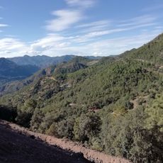
From an observation point, you can see across the entire Fuerte Valley and the landscape that ancient people knew. Modern LED lighting makes it possible to see fine details of the carvings even in low light.
The community of curious travelers
AroundUs brings together thousands of curated places, local tips, and hidden gems, enriched daily by 60,000 contributors worldwide.