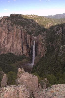
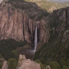
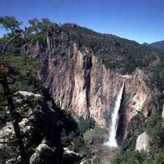
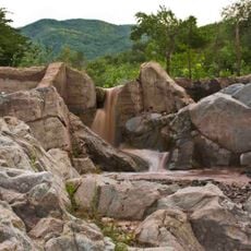
Basaseachic Falls, Waterfall in Ocampo, Mexico.
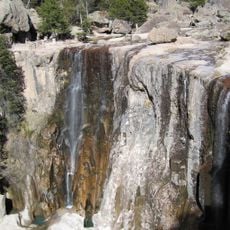
Basaseachic Falls lie in the Sierra Madre Occidental mountains of northern Mexico, where two streams join and drop 246 meters (807 feet) over a cliff edge into the Candameña Canyon. A fine mist forms at the point of impact and catches the light differently depending on the time of day and angle of the sun.
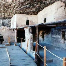
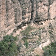
European travelers documented the waterfall in the 18th century, which led to the founding of the first settlement near the Mission of Tomochi. The area was later declared a national park to protect the forests and canyon from uncontrolled logging.
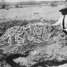
The name comes from the Rarámuri language and means place of the wolves, with Basachí referring to coyotes. Hikers today still encounter members of the indigenous community who live in the Sierra and have known the area for centuries.
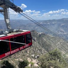
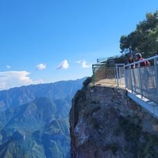
Several hiking trails lead to the rim or down into the canyon, with the shortest path taking about 15 minutes to the upper viewpoint. The descent to the canyon floor is longer and follows narrow trails that can become slippery after rain.
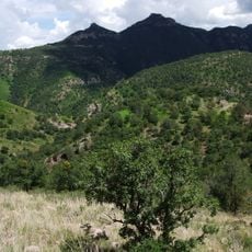
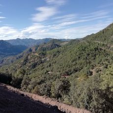
The surrounding national park is home to over 90 species of conifers and more than 70 species of oak, making it one of the most diverse forest regions in North America. Mountain lions and white-tailed deer move through these woods and are occasionally visible from the trails.
Location: Ocampo
Location: Chihuahua
Elevation above the sea: 1,943 m
GPS coordinates: 28.17417,-108.21278
Latest update: December 5, 2025 22:27
Waterfalls draw you in through your senses. You hear the roar of falling water, feel the mist on your skin, and watch light dance across the spray. Many of the most powerful examples are found in places that stay relatively untouched, where reaching them is half the reward. These destinations give...
Ferrocarril Chihuahua al Pacífico
80.3 km
Cuarenta Casas
153.6 km
Copper Canyon Adventure Park
82.4 km
Cumbres de Majalca National Park
183 km
Basaseachic Falls National Park
5.9 km
Esperanza Stone
145.5 km
Cascada de Cusárare
88.1 km
Huápoca
113.7 km
Piedra Volada
82 km
Sierra de Alamos - Río Cuchujaqui
132.8 km
Iglesia de la Purísima Concepción
146.7 km
Sacred Heart of Jesus Cathedral, Ciudad Obregón
185.4 km
Teleférico de las Barrancas del Cobre
82.5 km
Valley of Mushrooms
76.7 km
Álamos city hall
146.8 km
Plaza de Armas of Alamos
146.6 km
Capilla de Zapopan
146.4 km
Lake Oviáchic
170.6 km
Área de Protección de Flora y Fauna Tutuaca
36.3 km
Temple of Saint Rose of Lima
196.6 km
Customs Museum of Sonora
146.6 km
Temple of Our Father of Saint Ignatius of Loyola
147 km
Biblioteca Doctor Alfonso Ortiz Tirado
146.7 km
Temple of Saint Joseph
146.7 km
Mirador Cerro de Gallego
107.9 km
Bacanora State Museum
147 km
Recowata Hot Springs
81.3 km
Historic centre of Alamos
146.8 kmVisited this place? Tap the stars to rate it and share your experience / photos with the community! Try now! You can cancel it anytime.
Discover hidden gems everywhere you go!
From secret cafés to breathtaking viewpoints, skip the crowded tourist spots and find places that match your style. Our app makes it easy with voice search, smart filtering, route optimization, and insider tips from travelers worldwide. Download now for the complete mobile experience.
A unique approach to discovering new places❞
— Le Figaro
All the places worth exploring❞
— France Info
A tailor-made excursion in just a few clicks❞
— 20 Minutes