Chest opened
+${chestReward.xp} XP
Explorer
NOUVEAU ×${chestReward.collectible.quantity}
tapez pour fermer
Chest locked

Open chests in the app

Around Us is built for your phone — chests unlock when you walk, explore and capture nearby places.

Enable Location

We need your location to show you interesting places around you

Discover nearby places

Find interesting locations and hidden gems around you

Precise directions

Get accurate directions and distances to places

Your location is never shared with other users. It's only used when you tap the location button.

Log in to your account

Start exploring — it's free

Trusted by 72,993 travelers worldwide

Continue with Google
Continue with Apple
or

We will send you a code to connect

By continuing, you accept our Terms and Conditions and our Privacy Policy

Check your inbox

We've sent a pincode in your inbox. Please enter the code below.

San Vicente Mountain Park
Discussion Reviews Photo
2k Popularity

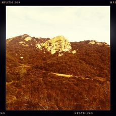
San Vicente Mountain Park, Hilltop park in Santa Monica Mountains, Los Angeles, United States.

San Vicente Mountain Park spreads across 10.2 acres with mountain biking trails, hiking paths, and equestrian routes through natural terrain along Mulholland Drive. The grounds feature several trails of varying difficulty that wind through the hillside landscape.

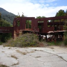
From 1956 to 1968, the location served as one of sixteen Nike-Ajax missile installations protecting Los Angeles from aircraft during the Cold War. The facility was a key part of the region's air defense network.

The site serves as a gathering space where locals come to exercise and learn, with information panels explaining Cold War defense technology and native plant and animal life.

Access requires a ten-minute walk on a dirt road from the parking area, with the park open from sunrise to sunset daily. Bring sturdy shoes and water, especially during warmer months, as shade is limited on many trails.

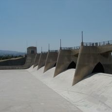
The original radar tower still stands at the site, offering views across the Santa Monica Mountains, Encino Reservoir, San Fernando Valley, and Los Angeles Basin. This structure serves as a visible reminder of the location's military past.

The community of curious travelers

AroundUs brings together thousands of curated places, local tips, and hidden gems, enriched daily by 60,000 contributors worldwide.

Start exploring
GPS coordinates
34.12900,-118.51300
Latest update
December 14, 2025 09:44
Around this place
Mulholland Drive
United States of America

Mulholland Drive

2.1 km
Getty Center
United States of America

Getty Center

6.7 km
J. Paul Getty Museum
United States of America

J. Paul Getty Museum

6.8 km
Riviera Country Club
United States of America

Riviera Country Club

8.9 km
Chartwell Mansion
United States of America

Chartwell Mansion

8 km
Sheats Goldstein Residence
United States of America

Sheats Goldstein Residence

8.2 km
Murphy Ranch
United States of America

Murphy Ranch

6.3 km
Sepulveda Dam
United States of America

Sepulveda Dam

5.6 km
George Sturges House
United States of America

George Sturges House

7.5 km
Will Rogers State Historic Park
United States of America

Will Rogers State Historic Park

8.3 km
Topanga State Park
United States of America

Topanga State Park

5 km
Bel-Air Country Club
United States of America

Bel-Air Country Club

8.1 km
Thomas Mann House
United States of America

Thomas Mann House

7.9 km
UCLA Drake Track and Field Stadium
United States of America

UCLA Drake Track and Field Stadium

8.7 km
Bel Air Presbyterian Church
United States of America

Bel Air Presbyterian Church

2.6 km
The Japanese Garden
United States of America

The Japanese Garden

6.8 km
United States of America

Stone Canyon Reservoir

5.8 km
Los Encinos State Historic Park
United States of America

Los Encinos State Historic Park

3.7 km
Wallis Annenberg Stadium
United States of America

Wallis Annenberg Stadium

8.8 km
United States of America

Van Nuys City Hall

8.7 km
Valley Beth Shalom
United States of America

Valley Beth Shalom

4.4 km
Landfair Apartments
United States of America

Landfair Apartments

8.9 km
Cathedral of St. Mary Byzantine Catholic Church
United States of America

Cathedral of St. Mary Byzantine Catholic Church

6 km
Van Nuys Branch
United States of America

Van Nuys Branch

8.5 km
Eagle Rock
United States of America

Eagle Rock

5.8 km
UCLA University Residence
United States of America

UCLA University Residence

8.8 km
UCLA Straus Stadium
United States of America

UCLA Straus Stadium

8.8 km
Playtime Co.
United States of America

Playtime Co.

8.3 km
Show the full map
Reviews
Share your experience

No review yet

Discussions
Start a discussion...

No discussion yet

« San Vicente Mountain Park - Hilltop park in Santa Monica Mountains, Los Angeles, United States » is provided by Around Us (aroundus.com). Images and texts are derived from Wikimedia project under a Creative Commons license. You are allowed to copy, distribute, and modify copies of this page, under the conditions set by the license, as long as this note is clearly visible.

Discover hidden gems everywhere you go!

From secret cafés to breathtaking viewpoints, skip the crowded tourist spots and find places that match your style. Our app makes it easy with voice search, smart filtering, route optimization, and insider tips from travelers worldwide. Download now for the complete mobile experience.

Around Us App Screenshot

A unique approach to discovering new places

Le Figaro

All the places worth exploring

France Info

A tailor-made excursion in just a few clicks

20 Minutes

Around Us
Travel Guide & Maps
Download

Send to your phone

QR Code
1

Open the camera app on your mobile.

2

Point at the QR code with your camera. A notification will appear.

3

Tap the notification to open the link.