Morro da Igreja, Mountain peak in Santa Catarina, Brazil.
Morro da Igreja is a mountain peak in the Serra Geral range reaching 1,822 meters (5,977 feet) and is the highest inhabited point in Santa Catarina. The summit hosts radar and radio equipment operated by the Brazilian Air Force for regional air traffic management.
The peak gained attention in 1996 when Brazil's lowest unofficial temperature of -17.8 degrees Celsius was recorded there. This extreme weather event brought the location into wider recognition beyond the local region.
Military installations operate at the summit for air traffic control across Brazil's southern region. The presence of these facilities shapes how locals and visitors experience this high mountain location.
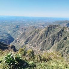
You can drive to the summit via SC 439 road from Urubici, where a paved route extends 18 kilometers to the peak. The journey usually takes one to two hours depending on weather and road conditions.
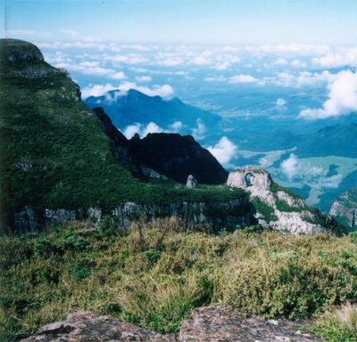
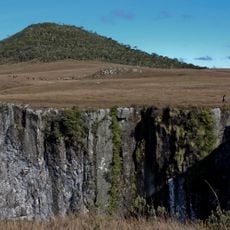
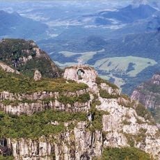
A natural stone arch called Pedra Furada is visible from the summit and marks the landscape. The mountain receives regular snowfall during winter months, which is rare for Brazil.
Location: Santa Catarina
Elevation above the sea: 1,822 m
GPS coordinates: -28.12591,-49.47456
Latest update: December 6, 2025 16:03
The South Region of Brazil brings together nature reserves, waterfalls, beaches, and mountain peaks. Here you find geological formations such as canyons and caves, plus islands with archaeological sites. The landscape ranges from the Atlantic coast to inland highlands, where subtropical rainforest...
Guarda do Embaú
90 km
Santa Marta Lighthouse
83.8 km
Serra do Rio do Rastro
26 km
Pico do Monte Negro
63.5 km
Serra do Tabuleiro State Park
66.7 km
São Joaquim National Park
7.4 km
Museum Anita Garibaldi
78.4 km
Cascata do Avencal
16.5 km
Museu Casa de Anita
78.8 km
Parque Estadual da Serra Furada
9.2 km
Museu Willy Zumblick
59.3 km
St. Joseph's Cathedral, Criciúma
62.2 km
Cachoeira que Congela
43.4 km
Memorial Nereu Ramos
90.6 km
Baleia Franca Environmental Protection Area
79.9 km
Araranguá Lighthouse
90.7 km
Imbituba lighthouse
82.1 km
Museu da Colonização Uberto Brüning Schlickmann
36.3 km
Praia do Rosa
82.2 km
Casa Pinto D'Ulisséa
78.8 km
Marco do Tratado de Tordesilhas
78.3 km
Imóvel situado à Av. Presidente Vargas, 43
46.6 km
Imóvel situado à Estrada Geral de Pedrinhas
45.2 km
Santo Ofício
85 km
Monument to Anita Garibaldi
78.5 km
Cine Show Tubarão
60.7 km
Historic center of Laguna
78.5 km
Cascata Encantada
74.3 kmVisited this place? Tap the stars to rate it and share your experience / photos with the community! Try now! You can cancel it anytime.
Discover hidden gems everywhere you go!
From secret cafés to breathtaking viewpoints, skip the crowded tourist spots and find places that match your style. Our app makes it easy with voice search, smart filtering, route optimization, and insider tips from travelers worldwide. Download now for the complete mobile experience.
A unique approach to discovering new places❞
— Le Figaro
All the places worth exploring❞
— France Info
A tailor-made excursion in just a few clicks❞
— 20 Minutes