See the monuments around you in AROpen chests in the app
Around Us is built for your phone — point your camera at the streets and discover the monuments and places around you in augmented reality.Around Us is built for your phone — chests unlock when you walk, explore and capture nearby places.
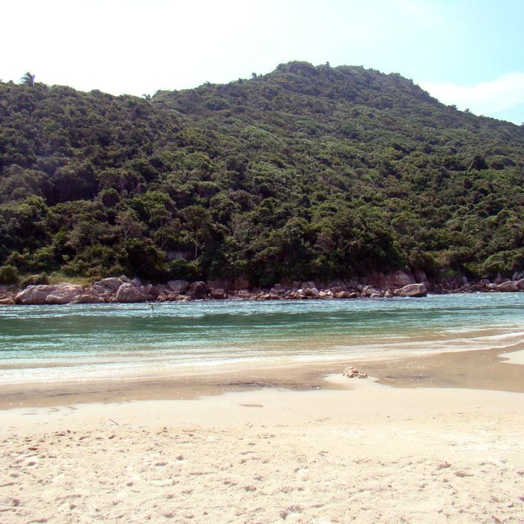
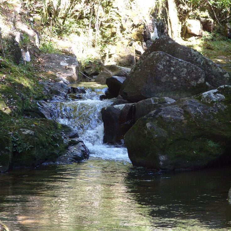
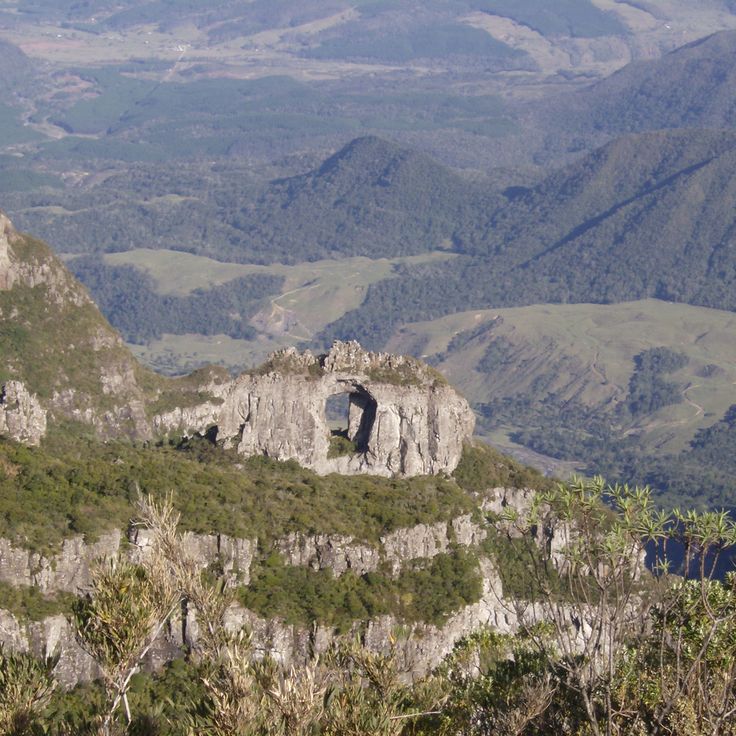
The South Region of Brazil brings together nature reserves, waterfalls, beaches, and mountain peaks. Here you find geological formations such as canyons and caves, plus islands with archaeological sites. The landscape ranges from the Atlantic coast to inland highlands, where subtropical rainforest grows and rivers run through gorges.
The region offers surf areas like Guarda do Embaú and Praia do Rosa, hiking trails through Cânion Itaimbezinho and Cânion Fortaleza, and mountain destinations such as Pico Paraná and Morro da Igreja. Nature parks like Parque Nacional de Aparados da Serra and Reserva Natural Salto Morato protect native species and ecosystems. Visitors can explore sandstone formations at Parque Estadual de Vila Velha, walk through caves like Gruta de Botuverá, or visit islands such as Ilha do Campeche. Serra do Rio do Rastro winds through curves into the mountains, while waterfalls like Cachoeira do Avencal and Cascata Encantada drop through forests.
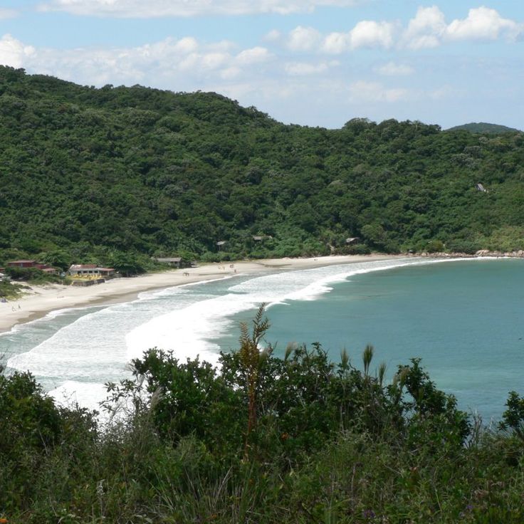
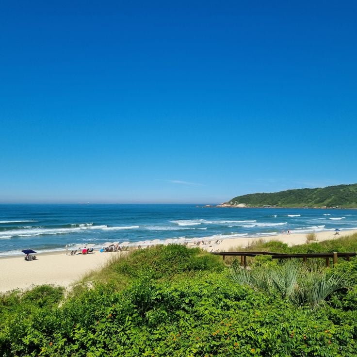
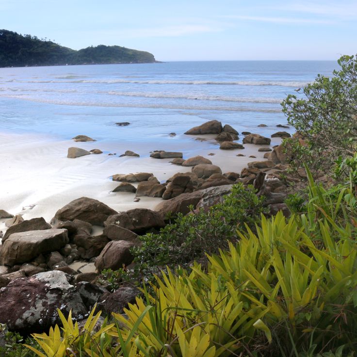
This beach near Palhoça offers gentle waves for beginning and intermediate surfers. The river mouth forms a sheltered lagoon where water flows more calmly. Guarda do Embaú sits among forested hills of Atlantic rainforest that reach down to the shore. Fishermen cross the river in small boats, and walkers follow the sandy path along the coast. The area feels secluded, with few houses and simple restaurants by the water.
This mountain road runs through the Serra Geral and connects the coastal plain with the highland plateau of Santa Catarina. The route was built in the 1920s and winds through dense subtropical rainforest. From the viewpoints along the road you can see the coast and the forested slopes. On clear days the view reaches across several valleys. The curves are tight and the drive takes about an hour. Along the route there are small stands selling regional products.
This island within South Brazil's natural and cultural sites preserves prehistoric rock carvings that are thousands of years old. The shallow, clear waters around Ilha do Campeche are excellent for snorkeling. Sandy beaches run along the coast. Visitors reach the island by boat from Florianópolis. The rock formations show patterns and symbols from earlier inhabitants. A trail runs through low vegetation to the archaeological sites. The number of daily visitors is limited to protect the surroundings.
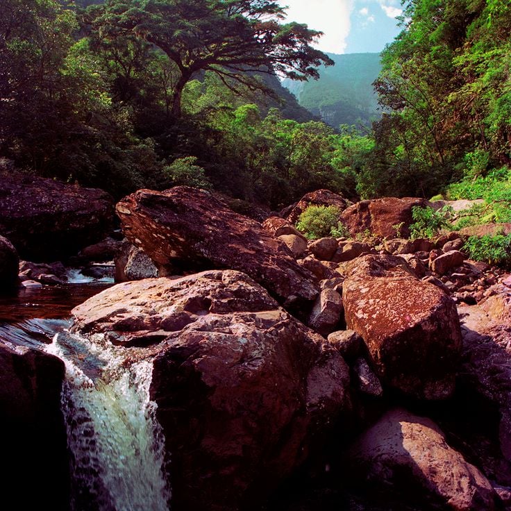
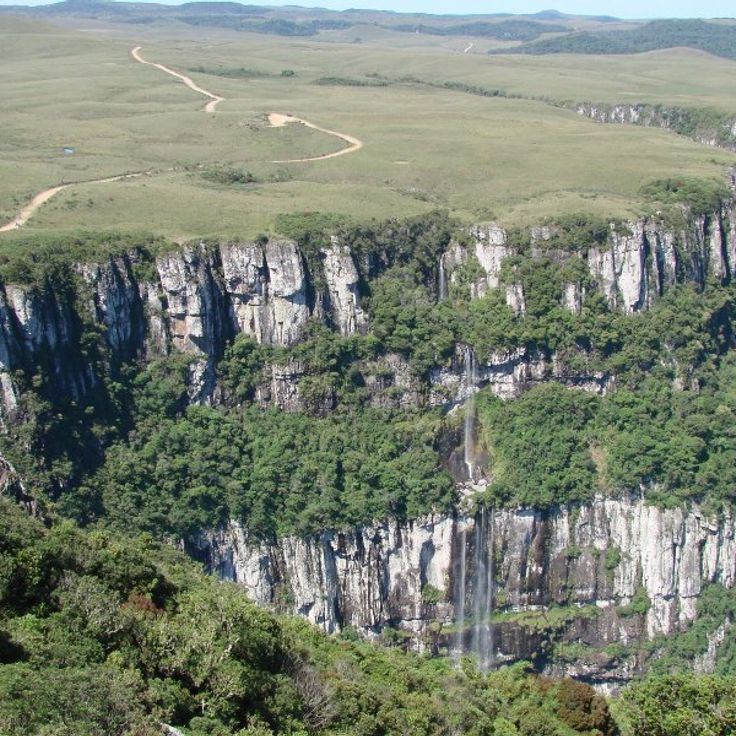
The Cânion Malacara is one of the natural sites found in South Brazil's mountain region. This canyon features rock walls rising 720 meters (2,360 feet) in height. A waterfall flows through red sandstone formations. The area sits where deep gorges and subtropical rainforest meet. Trails lead through the valley, where the river runs between steep walls and spills into natural pools.
Rota das Cachoeiras is a hiking route near Corupá that passes through 14 waterfalls in the Atlantic rainforest of South Brazil. The trail leads through dense vegetation, past streams and forest sections where the sound of falling water can be heard from afar. The waterfalls vary in height and form natural pools at the base of the rocks. Walking this route shows the landscape of the subtropical rainforest and connects nature reserves with the region's hiking trails.
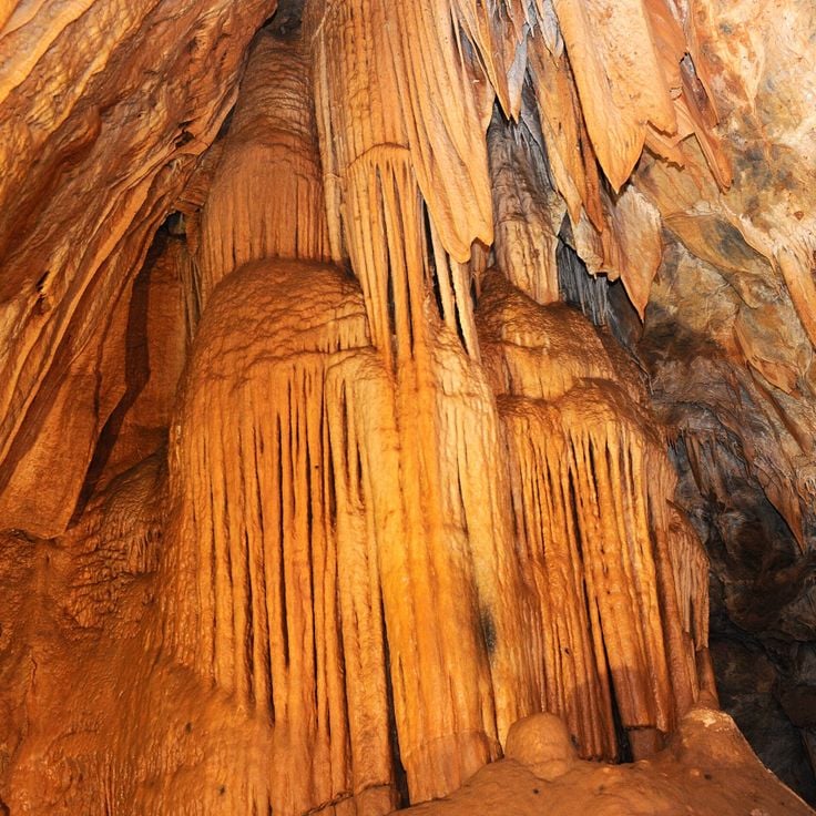
Gruta de Botuverá is a cave that leads through an underground complex where stalactites, stalagmites and calcite formations appear across several chambers. The marked path extends for 200 meters and reveals geological structures formed over thousands of years by water deposits. The interior remains cool and damp, with irregular walls and ceilings that reflect the slow growth of mineral formations. Visitors follow a set route through the darkness while artificial light brings out the textures and shapes of the deposits.
This mountain in Urubici rises to 1822 meters (5978 feet) and features a rock formation with a natural opening near the summit. Morro da Igreja sits in the highlands of Santa Catarina and is often wrapped in thick fog that covers the landscape and limits visibility. Temperatures here can be cool even in summer, and snow occasionally falls in winter. Access is by unpaved roads that pass through grassland and low vegetation. From the top, on clear days, you can see across the surrounding valleys and hills. The rock formation with the hole is a popular subject for visitors who hike to the summit.
This waterfall in the highland region of South Brazil drops one hundred meters over a rock face. The trail to reach it runs through subtropical forest and covers about two kilometers. Visitors can walk the path on foot or choose a horseback tour that also leads to the base of the falls. Cachoeira do Avencal sits in an area known for its geological formations and hiking opportunities.
This waterfall lies within the Atlantic Rainforest of southern Brazil. The grounds around Cascata Encantada offer seating areas where visitors can rest and listen to the water flowing through the forest. The site fits within the South Region's collection of nature reserves, waterfalls, beaches, and mountain peaks that stretch from the Atlantic coast to inland highlands.
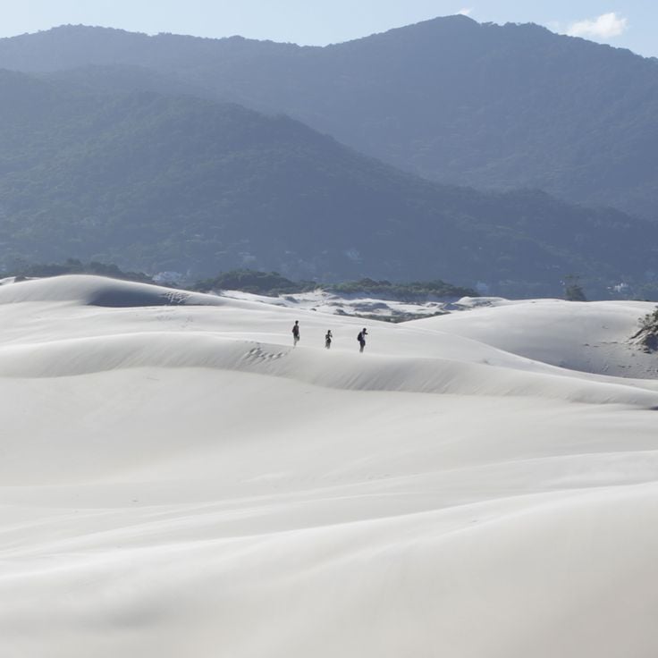
Dunas da Joaquina sits on the southern part of Santa Catarina Island and represents the dune formations that shape the geology of South Brazil. Wind and coastal forces have molded these sand hills, which rise to 40 meters (130 feet) above sea level and stretch for several kilometers along the eastern shore. Visitors ride sandboards down the slopes, while others take in views of the Atlantic or simply walk across the rolling terrain. The fine, light sand catches sunlight and shifts color as the day passes. Late in the afternoon, people gather here to watch the sunset before heading to the beach nearby.
The stone arch of Pedra Furada rises above the ocean and shows prehistoric paintings on its walls. This site is reached along marked paths that lead through the vegetation. The natural opening in the rock formed over thousands of years through wind and waves. At low tide you can step closer to the base and see traces of human settlement from earlier times. Pedra Furada belongs to the natural and cultural sites of South Brazil, where geological formations and human history meet.
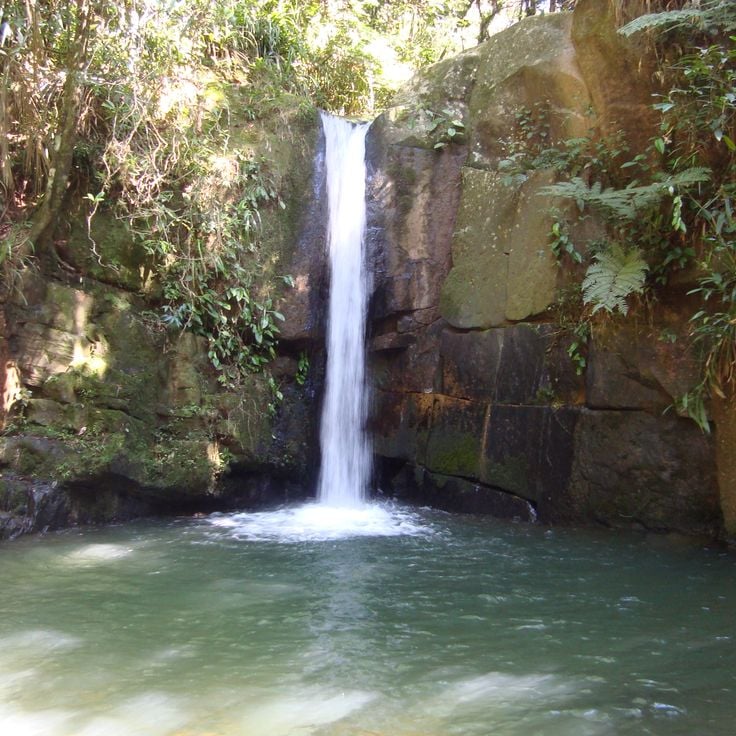
Tigre Preto Waterfall in Santa Catarina drops 60 meters over granite rocks and is surrounded by dense forest that shelters native plants and many bird species. After a hike through subtropical rainforest, this waterfall offers a refreshing natural experience with clear water and moss-covered stones in the mountains of Santa Catarina.
This canyon is part of the natural and cultural sites found across South Brazil's landscape, which ranges from the Atlantic coast to inland highlands. The Cânion Fortaleza offers rock walls that drop about 900 meters (3000 feet). Several hiking trails lead to viewing platforms at different heights, from where you can see the surrounding area. The trails are marked and pass through vegetation adapted to the elevation. The rock shows layers formed over long periods, and the edges fall sharply into the depths.
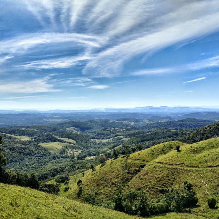
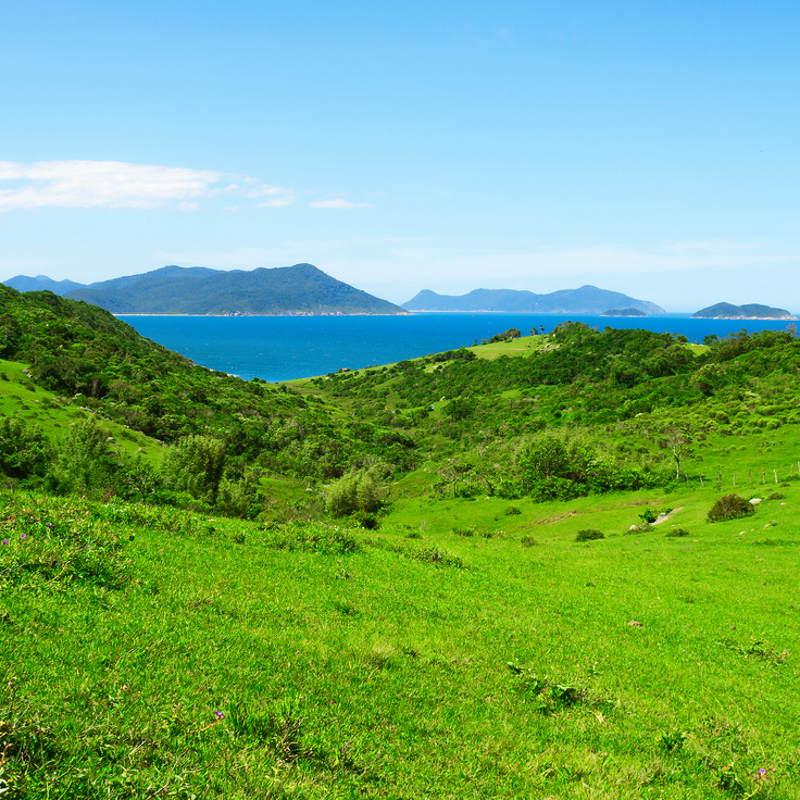
This valley lies south of Florianópolis and displays a landscape of meadows, forested hills and gentle rises. The terrain shifts between open areas and denser woodland sections where subtropical plant species grow. Walking paths lead through the different vegetation zones, and you can notice the changes in topography as you move through. The surroundings are used by local communities who come here to walk or explore the nature. The Vale da Utopia is one of the natural areas in South Brazil where mountains, forests and coastal proximity meet.
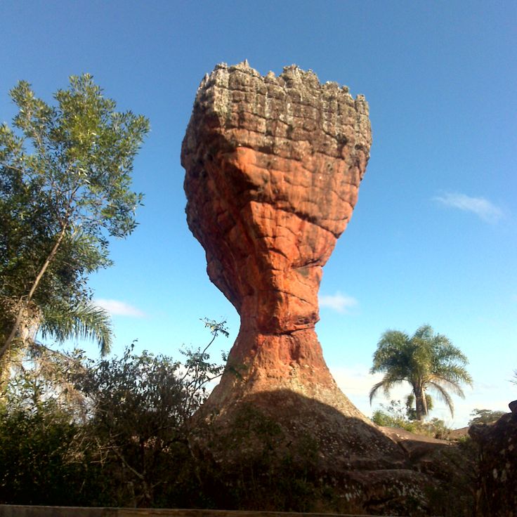
Parque Estadual de Vila Velha displays red sandstone formations shaped by wind and rain over millions of years. The rocks stand like natural pillars across the landscape and carry names that reflect their shapes. Plants native to the region grow between the stones, and local birds use the caves for shelter. Visitors walk along marked trails through the grounds and see the different structures up close.
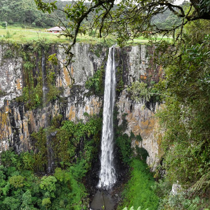
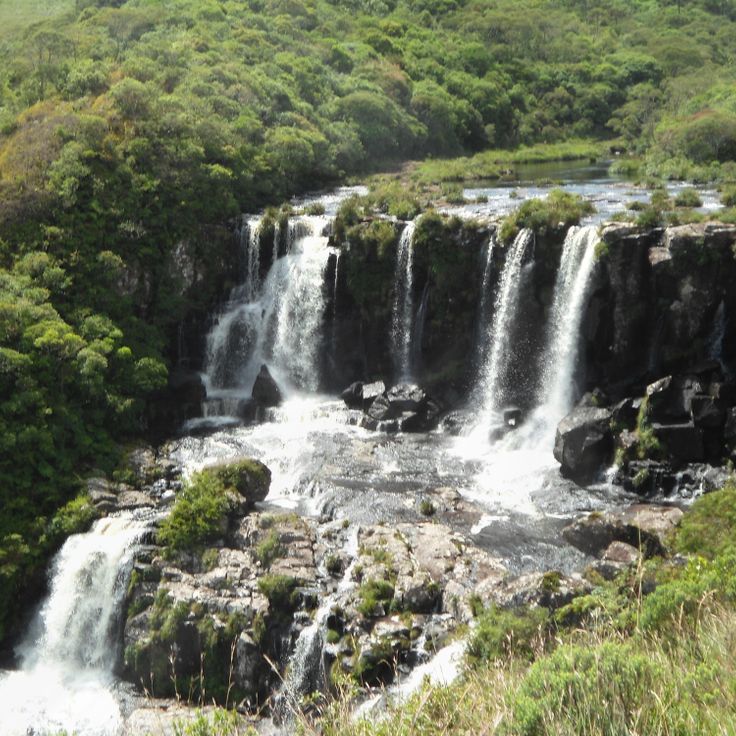
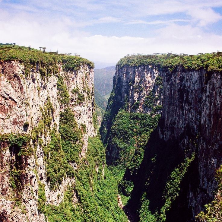
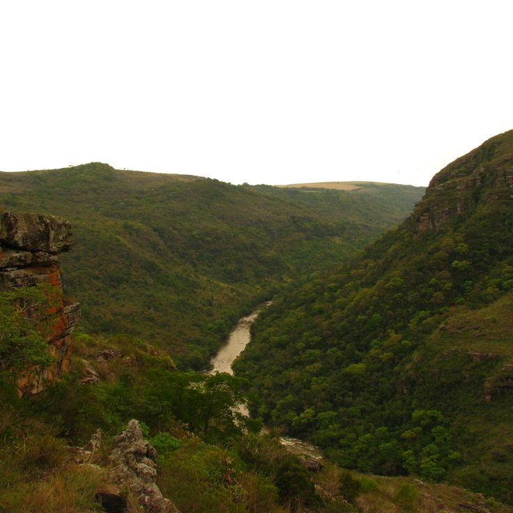
This canyon cuts into the highland plateau of Rio Grande do Sul with steep rock walls dropping more than 700 meters below. Two waterfalls cascade year-round over the cliffs, while hiking trails wind through Atlantic rainforest and Araucaria woodland along the upper rim and down to the canyon floor. The base of Cânion Itaimbezinho lies covered in thick vegetation between parallel rock walls extending about six kilometers. Fog drifts through the gorge, shifting the view across to the opposite walls. Visitors follow marked paths that lead to different viewpoints along the cliff edge and to one descent reaching the canyon bottom. This geological formation arose through erosion of basalt rock from volcanic origins that shaped the landscape millions of years ago.
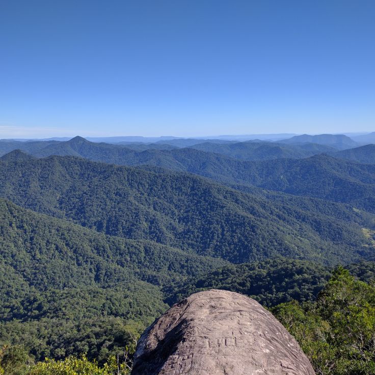
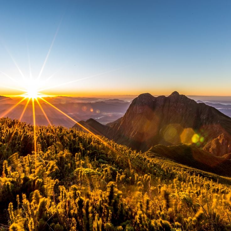
This granite rock rises to 1160 meters (3800 feet) and ranks among the most recognized mountain formations in the southern Brazilian highlands. The steep rock faces attract climbers from different regions, who find routes with varying levels of difficulty here. From the top of Pedra do Baú, views open across the forested slopes of the Mantiqueira range, where valleys and additional peaks extend to the horizon.
Morro Spitzkopf is a mountain within this collection of natural sites in South Brazil, rising 915 meters (3,000 feet) above the city of Blumenau and the Itajaí Valley. The climb passes through subtropical rainforest that shifts to cloud forest at higher elevations. Several trails of different difficulty levels reach the summit, where visitors often watch clouds drift below. On clear days, the view stretches to surrounding mountain ranges. The vegetation changes with elevation, from dense trees at lower levels to more open areas near the peak. Morning and evening light offers favorable conditions for viewing. Rock faces provide several climbing routes.
This summit in the Serra do Mar rises to 1856 meters (6088 feet) and offers hiking trails through Atlantic rainforest. Pico Caratuva sits surrounded by dense vegetation that shifts with altitude. Mist often moves through the upper slopes, wrapping the treetops in damp air. The climb follows rocky paths and roots, passing ferns and mosses along the way. At the top, views open over the surrounding ridges and valleys. Temperature drops as you gain height, and wind is common along the crest. This mountain forms part of the natural and cultural sites in South Brazil, where mountain formations meet subtropical forest.
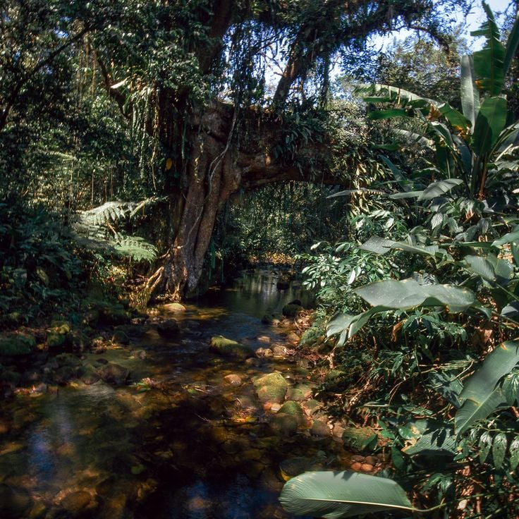
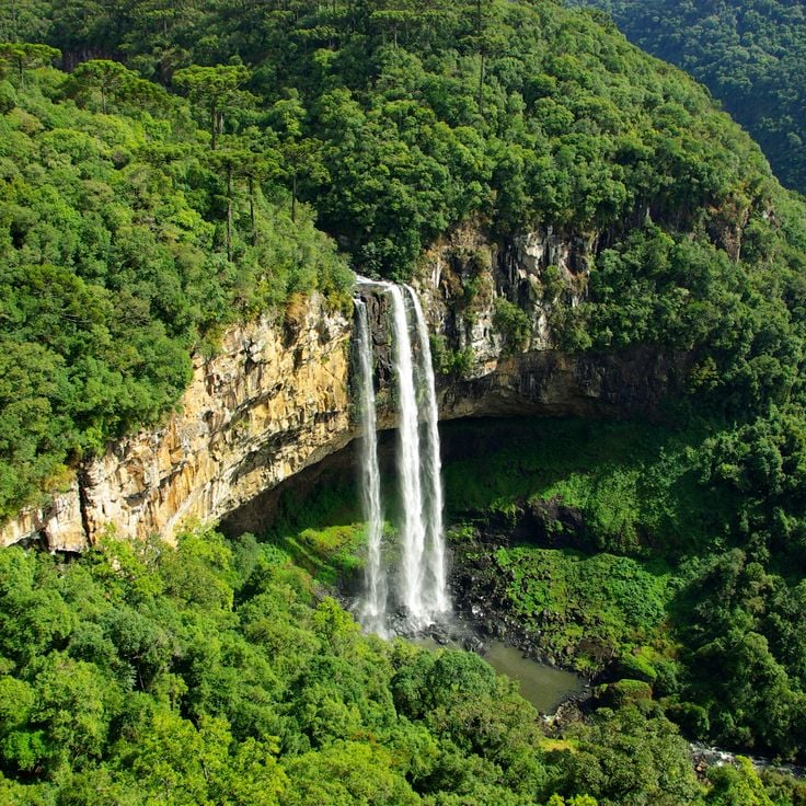
This nature reserve protects over 2,300 hectares of Atlantic rainforest in the coastal mountain range of South Brazil. A 130-meter waterfall drops through dense forest and forms the centerpiece of the reserve. Trails lead through forest sections where more than 300 bird species live. Visitors hear the sound of rushing water from a distance and can explore different vegetation zones. The reserve shows how the Atlantic rainforest grows without human interference and which animal species find natural habitat here.
This national park lies on a high plateau along the border between the Brazilian states of Rio Grande do Sul and Santa Catarina. The landscape is shaped by deep canyons carved from dark basalt rock, with walls that drop more than 700 meters in some places. Waterfalls tumble over the edges and disappear into the dense subtropical rainforest at the canyon floors. Hiking trails run along the rim and offer views of the forested slopes. Pumas, deer, and many bird species live in the forests. Mist often moves through the canyons and wraps the rock faces in damp air.
This rocky island in the Atlantic Ocean shelters South American fur seals and seabirds. Ilha dos Lobos lies off the coast of Torres and forms part of the nature reserves in South Brazil. Visitors watch the seal colonies from shore, as the island itself remains protected. The surrounding waters draw fishermen and nearby beaches belong to known surf areas. Rough cliffs and open water define the character of this coastal landscape.
Praia do Rosa is a sandy beach where surfers gather to ride the strong waves. Southern right whales arrive in the bay from July to November and stay close to the coast. You can watch these animals from the beach or take boats to see them up close. The water is cool and the currents run strong. Between the rocks you find calmer spots for swimming. Green hills reach down to the shore and frame the coastline.
Parque Estadual do Turvo protects subtropical rainforest in the north of Rio Grande do Sul. Jaguars, tapirs, toucans, and howler monkeys live in this park. The Yucumã waterfall on the Uruguay River drops across roughly 1800 meters (nearly 6000 feet), forming one of the longest horizontal cascades in the world. Walking trails lead through the forest and to viewpoints along the river.
This mountain stands in the Atlantic coastal ranges of Paraná and reaches 1,877 meters (6,157 feet), making it the highest point in southern Brazil. Pico Paraná lies within a protected area covered in dense Atlantic rainforest, where mist and clouds often wrap around the landscape. The climbing routes move through steep rock faces and require alpine equipment and experience in mountaineering. The ascent begins in a valley and crosses different vegetation zones before reaching the rocky sections near the summit. From the highest point, you can see the surrounding mountains and forested valleys on clear days.
Caracol Falls is a waterfall that drops 130 meters over dark basalt cliffs into a forested valley within the South Region's collection of natural sites. The water strikes granite formations at the base of the falls and sends a fine mist into the air. A panoramic walkway leads to several viewing platforms where you can see the full height of the cascade. Birds such as toucans and parrots fly between the trees along the edge of the gorge. The path winds through subtropical rainforest where ferns and bromeliads grow on tree trunks. On sunny days a rainbow often appears in the spray from the waterfall.
The Parque das Aves is located in Foz do Iguaçu in the south of the region and forms part of South Brazil's network of nature reserves and forest landscapes. This park sits within subtropical rainforest and houses more than 1400 birds from about 150 species in large aviaries designed to mirror their natural habitats. Butterflies and reptiles also thrive here. The paths wind through thick forest where parrots and toucans fly through the canopy.
This waterfall drops into the depths and often disappears into mist before reaching the bottom. The surrounding area is home to native plants and animals that live among the moist rock walls and forests nearby. Walking trails lead through the vegetation to viewpoints where you can watch the water as it tumbles into the canyon. This site is part of South Brazil's natural and cultural areas, where waterfalls cascade through forests and rivers run through gorges.
This island lies off the coast between the Atlantic rainforest and the open ocean. Ilha do Cardoso protects mangrove forests, undisturbed beaches, and dense woods where toucans, parrots, and other tropical birds make their home. The reserve preserves one of the last continuous coastal rainforests in the region and allows visitors to paddle through quiet bays or walk trails to observe the diversity of life. Small fishing villages on the island show the traditional ways of coastal communities, while the shores are washed by Atlantic waves.
Guartelá Canyon cuts through a landscape of tall rock walls and dense green covering much of the floor below. Hiking paths lead over uneven ground and offer views into the gorge and across the surrounding plateaus. The stone shows layers formed over long periods, and some sections are steep and rocky. Those who walk here often hear birds and see small streams running between the stones. Vegetation shifts from open areas to wooded slopes, and in places trees grow from the ledges. The trail requires attention, but the perspectives into the depth and the expanse make the effort worthwhile. This canyon is one of the geological formations that define the South Region of Brazil, where you encounter gorges, waterfalls, and forested mountains.
Naufragados Beach stretches three kilometers along the coast of Florianópolis with light, fine sand. The 19th century lighthouse stands at the end of the beach and has guided ships for over a hundred years. The water here is usually calm. The paths to reach the beach lead through dense subtropical rainforest, making access somewhat difficult. Few visitors come on an ordinary day. The name recalls shipwrecks that happened when the coast had no beacons. This beach is part of South Brazil's natural and cultural sites, where shores and lighthouses tell stories of the sea.
This beach near Palhoça offers gentle waves for beginning and intermediate surfers. The river mouth forms a sheltered lagoon where water flows more calmly. Guarda do Embaú sits among forested hills of Atlantic rainforest that reach down to the shore. Fishermen cross the river in small boats, and walkers follow the sandy path along the coast. The area feels secluded, with few houses and simple restaurants by the water.
This mountain road runs through the Serra Geral and connects the coastal plain with the highland plateau of Santa Catarina. The route was built in the 1920s and winds through dense subtropical rainforest. From the viewpoints along the road you can see the coast and the forested slopes. On clear days the view reaches across several valleys. The curves are tight and the drive takes about an hour. Along the route there are small stands selling regional products.
This island within South Brazil's natural and cultural sites preserves prehistoric rock carvings that are thousands of years old. The shallow, clear waters around Ilha do Campeche are excellent for snorkeling. Sandy beaches run along the coast. Visitors reach the island by boat from Florianópolis. The rock formations show patterns and symbols from earlier inhabitants. A trail runs through low vegetation to the archaeological sites. The number of daily visitors is limited to protect the surroundings.
The Cânion Malacara is one of the natural sites found in South Brazil's mountain region. This canyon features rock walls rising 720 meters (2,360 feet) in height. A waterfall flows through red sandstone formations. The area sits where deep gorges and subtropical rainforest meet. Trails lead through the valley, where the river runs between steep walls and spills into natural pools.
Rota das Cachoeiras is a hiking route near Corupá that passes through 14 waterfalls in the Atlantic rainforest of South Brazil. The trail leads through dense vegetation, past streams and forest sections where the sound of falling water can be heard from afar. The waterfalls vary in height and form natural pools at the base of the rocks. Walking this route shows the landscape of the subtropical rainforest and connects nature reserves with the region's hiking trails.
Gruta de Botuverá is a cave that leads through an underground complex where stalactites, stalagmites and calcite formations appear across several chambers. The marked path extends for 200 meters and reveals geological structures formed over thousands of years by water deposits. The interior remains cool and damp, with irregular walls and ceilings that reflect the slow growth of mineral formations. Visitors follow a set route through the darkness while artificial light brings out the textures and shapes of the deposits.
This mountain in Urubici rises to 1822 meters (5978 feet) and features a rock formation with a natural opening near the summit. Morro da Igreja sits in the highlands of Santa Catarina and is often wrapped in thick fog that covers the landscape and limits visibility. Temperatures here can be cool even in summer, and snow occasionally falls in winter. Access is by unpaved roads that pass through grassland and low vegetation. From the top, on clear days, you can see across the surrounding valleys and hills. The rock formation with the hole is a popular subject for visitors who hike to the summit.
This waterfall in the highland region of South Brazil drops one hundred meters over a rock face. The trail to reach it runs through subtropical forest and covers about two kilometers. Visitors can walk the path on foot or choose a horseback tour that also leads to the base of the falls. Cachoeira do Avencal sits in an area known for its geological formations and hiking opportunities.
This waterfall lies within the Atlantic Rainforest of southern Brazil. The grounds around Cascata Encantada offer seating areas where visitors can rest and listen to the water flowing through the forest. The site fits within the South Region's collection of nature reserves, waterfalls, beaches, and mountain peaks that stretch from the Atlantic coast to inland highlands.
Dunas da Joaquina sits on the southern part of Santa Catarina Island and represents the dune formations that shape the geology of South Brazil. Wind and coastal forces have molded these sand hills, which rise to 40 meters (130 feet) above sea level and stretch for several kilometers along the eastern shore. Visitors ride sandboards down the slopes, while others take in views of the Atlantic or simply walk across the rolling terrain. The fine, light sand catches sunlight and shifts color as the day passes. Late in the afternoon, people gather here to watch the sunset before heading to the beach nearby.
The stone arch of Pedra Furada rises above the ocean and shows prehistoric paintings on its walls. This site is reached along marked paths that lead through the vegetation. The natural opening in the rock formed over thousands of years through wind and waves. At low tide you can step closer to the base and see traces of human settlement from earlier times. Pedra Furada belongs to the natural and cultural sites of South Brazil, where geological formations and human history meet.
Tigre Preto Waterfall in Santa Catarina drops 60 meters over granite rocks and is surrounded by dense forest that shelters native plants and many bird species. After a hike through subtropical rainforest, this waterfall offers a refreshing natural experience with clear water and moss-covered stones in the mountains of Santa Catarina.
This canyon is part of the natural and cultural sites found across South Brazil's landscape, which ranges from the Atlantic coast to inland highlands. The Cânion Fortaleza offers rock walls that drop about 900 meters (3000 feet). Several hiking trails lead to viewing platforms at different heights, from where you can see the surrounding area. The trails are marked and pass through vegetation adapted to the elevation. The rock shows layers formed over long periods, and the edges fall sharply into the depths.
This valley lies south of Florianópolis and displays a landscape of meadows, forested hills and gentle rises. The terrain shifts between open areas and denser woodland sections where subtropical plant species grow. Walking paths lead through the different vegetation zones, and you can notice the changes in topography as you move through. The surroundings are used by local communities who come here to walk or explore the nature. The Vale da Utopia is one of the natural areas in South Brazil where mountains, forests and coastal proximity meet.
Parque Estadual de Vila Velha displays red sandstone formations shaped by wind and rain over millions of years. The rocks stand like natural pillars across the landscape and carry names that reflect their shapes. Plants native to the region grow between the stones, and local birds use the caves for shelter. Visitors walk along marked trails through the grounds and see the different structures up close.
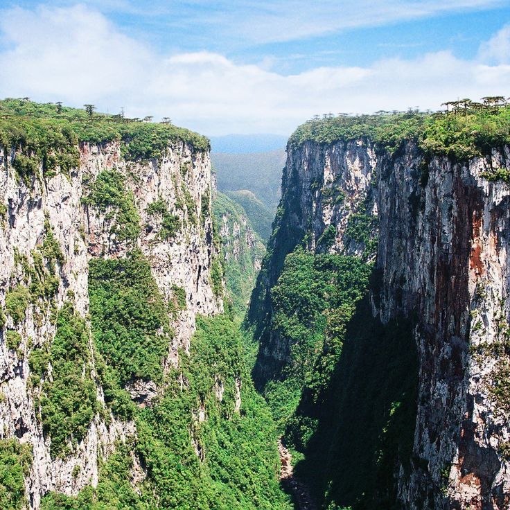
This canyon cuts into the highland plateau of Rio Grande do Sul with steep rock walls dropping more than 700 meters below. Two waterfalls cascade year-round over the cliffs, while hiking trails wind through Atlantic rainforest and Araucaria woodland along the upper rim and down to the canyon floor. The base of Cânion Itaimbezinho lies covered in thick vegetation between parallel rock walls extending about six kilometers. Fog drifts through the gorge, shifting the view across to the opposite walls. Visitors follow marked paths that lead to different viewpoints along the cliff edge and to one descent reaching the canyon bottom. This geological formation arose through erosion of basalt rock from volcanic origins that shaped the landscape millions of years ago.
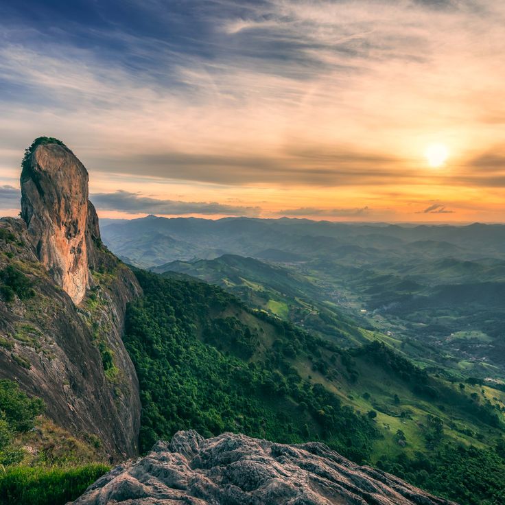
This granite rock rises to 1160 meters (3800 feet) and ranks among the most recognized mountain formations in the southern Brazilian highlands. The steep rock faces attract climbers from different regions, who find routes with varying levels of difficulty here. From the top of Pedra do Baú, views open across the forested slopes of the Mantiqueira range, where valleys and additional peaks extend to the horizon.
Morro Spitzkopf is a mountain within this collection of natural sites in South Brazil, rising 915 meters (3,000 feet) above the city of Blumenau and the Itajaí Valley. The climb passes through subtropical rainforest that shifts to cloud forest at higher elevations. Several trails of different difficulty levels reach the summit, where visitors often watch clouds drift below. On clear days, the view stretches to surrounding mountain ranges. The vegetation changes with elevation, from dense trees at lower levels to more open areas near the peak. Morning and evening light offers favorable conditions for viewing. Rock faces provide several climbing routes.
This summit in the Serra do Mar rises to 1856 meters (6088 feet) and offers hiking trails through Atlantic rainforest. Pico Caratuva sits surrounded by dense vegetation that shifts with altitude. Mist often moves through the upper slopes, wrapping the treetops in damp air. The climb follows rocky paths and roots, passing ferns and mosses along the way. At the top, views open over the surrounding ridges and valleys. Temperature drops as you gain height, and wind is common along the crest. This mountain forms part of the natural and cultural sites in South Brazil, where mountain formations meet subtropical forest.
This nature reserve protects over 2,300 hectares of Atlantic rainforest in the coastal mountain range of South Brazil. A 130-meter waterfall drops through dense forest and forms the centerpiece of the reserve. Trails lead through forest sections where more than 300 bird species live. Visitors hear the sound of rushing water from a distance and can explore different vegetation zones. The reserve shows how the Atlantic rainforest grows without human interference and which animal species find natural habitat here.
This national park lies on a high plateau along the border between the Brazilian states of Rio Grande do Sul and Santa Catarina. The landscape is shaped by deep canyons carved from dark basalt rock, with walls that drop more than 700 meters in some places. Waterfalls tumble over the edges and disappear into the dense subtropical rainforest at the canyon floors. Hiking trails run along the rim and offer views of the forested slopes. Pumas, deer, and many bird species live in the forests. Mist often moves through the canyons and wraps the rock faces in damp air.
This rocky island in the Atlantic Ocean shelters South American fur seals and seabirds. Ilha dos Lobos lies off the coast of Torres and forms part of the nature reserves in South Brazil. Visitors watch the seal colonies from shore, as the island itself remains protected. The surrounding waters draw fishermen and nearby beaches belong to known surf areas. Rough cliffs and open water define the character of this coastal landscape.
Praia do Rosa is a sandy beach where surfers gather to ride the strong waves. Southern right whales arrive in the bay from July to November and stay close to the coast. You can watch these animals from the beach or take boats to see them up close. The water is cool and the currents run strong. Between the rocks you find calmer spots for swimming. Green hills reach down to the shore and frame the coastline.
Parque Estadual do Turvo protects subtropical rainforest in the north of Rio Grande do Sul. Jaguars, tapirs, toucans, and howler monkeys live in this park. The Yucumã waterfall on the Uruguay River drops across roughly 1800 meters (nearly 6000 feet), forming one of the longest horizontal cascades in the world. Walking trails lead through the forest and to viewpoints along the river.
This mountain stands in the Atlantic coastal ranges of Paraná and reaches 1,877 meters (6,157 feet), making it the highest point in southern Brazil. Pico Paraná lies within a protected area covered in dense Atlantic rainforest, where mist and clouds often wrap around the landscape. The climbing routes move through steep rock faces and require alpine equipment and experience in mountaineering. The ascent begins in a valley and crosses different vegetation zones before reaching the rocky sections near the summit. From the highest point, you can see the surrounding mountains and forested valleys on clear days.
Caracol Falls is a waterfall that drops 130 meters over dark basalt cliffs into a forested valley within the South Region's collection of natural sites. The water strikes granite formations at the base of the falls and sends a fine mist into the air. A panoramic walkway leads to several viewing platforms where you can see the full height of the cascade. Birds such as toucans and parrots fly between the trees along the edge of the gorge. The path winds through subtropical rainforest where ferns and bromeliads grow on tree trunks. On sunny days a rainbow often appears in the spray from the waterfall.
The Parque das Aves is located in Foz do Iguaçu in the south of the region and forms part of South Brazil's network of nature reserves and forest landscapes. This park sits within subtropical rainforest and houses more than 1400 birds from about 150 species in large aviaries designed to mirror their natural habitats. Butterflies and reptiles also thrive here. The paths wind through thick forest where parrots and toucans fly through the canopy.
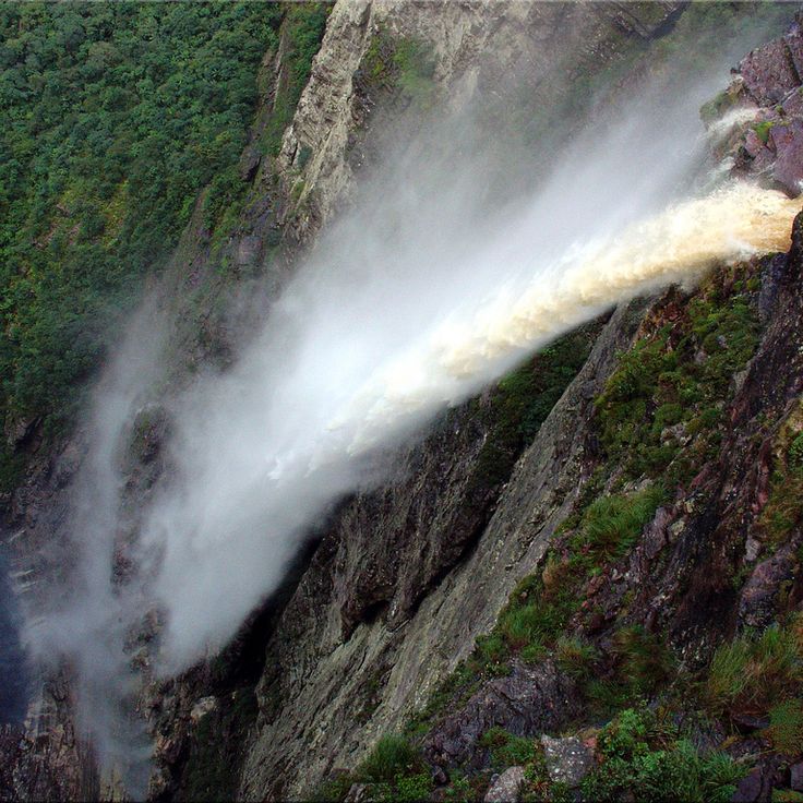
This waterfall drops into the depths and often disappears into mist before reaching the bottom. The surrounding area is home to native plants and animals that live among the moist rock walls and forests nearby. Walking trails lead through the vegetation to viewpoints where you can watch the water as it tumbles into the canyon. This site is part of South Brazil's natural and cultural areas, where waterfalls cascade through forests and rivers run through gorges.
This island lies off the coast between the Atlantic rainforest and the open ocean. Ilha do Cardoso protects mangrove forests, undisturbed beaches, and dense woods where toucans, parrots, and other tropical birds make their home. The reserve preserves one of the last continuous coastal rainforests in the region and allows visitors to paddle through quiet bays or walk trails to observe the diversity of life. Small fishing villages on the island show the traditional ways of coastal communities, while the shores are washed by Atlantic waves.
Guartelá Canyon cuts through a landscape of tall rock walls and dense green covering much of the floor below. Hiking paths lead over uneven ground and offer views into the gorge and across the surrounding plateaus. The stone shows layers formed over long periods, and some sections are steep and rocky. Those who walk here often hear birds and see small streams running between the stones. Vegetation shifts from open areas to wooded slopes, and in places trees grow from the ledges. The trail requires attention, but the perspectives into the depth and the expanse make the effort worthwhile. This canyon is one of the geological formations that define the South Region of Brazil, where you encounter gorges, waterfalls, and forested mountains.
Naufragados Beach stretches three kilometers along the coast of Florianópolis with light, fine sand. The 19th century lighthouse stands at the end of the beach and has guided ships for over a hundred years. The water here is usually calm. The paths to reach the beach lead through dense subtropical rainforest, making access somewhat difficult. Few visitors come on an ordinary day. The name recalls shipwrecks that happened when the coast had no beacons. This beach is part of South Brazil's natural and cultural sites, where shores and lighthouses tell stories of the sea.
This beach near Palhoça offers gentle waves for beginning and intermediate surfers. The river mouth forms a sheltered lagoon where water flows more calmly. Guarda do Embaú sits among forested hills of Atlantic rainforest that reach down to the shore. Fishermen cross the river in small boats, and walkers follow the sandy path along the coast. The area feels secluded, with few houses and simple restaurants by the water.
This mountain road runs through the Serra Geral and connects the coastal plain with the highland plateau of Santa Catarina. The route was built in the 1920s and winds through dense subtropical rainforest. From the viewpoints along the road you can see the coast and the forested slopes. On clear days the view reaches across several valleys. The curves are tight and the drive takes about an hour. Along the route there are small stands selling regional products.
This island within South Brazil's natural and cultural sites preserves prehistoric rock carvings that are thousands of years old. The shallow, clear waters around Ilha do Campeche are excellent for snorkeling. Sandy beaches run along the coast. Visitors reach the island by boat from Florianópolis. The rock formations show patterns and symbols from earlier inhabitants. A trail runs through low vegetation to the archaeological sites. The number of daily visitors is limited to protect the surroundings.
The Cânion Malacara is one of the natural sites found in South Brazil's mountain region. This canyon features rock walls rising 720 meters (2,360 feet) in height. A waterfall flows through red sandstone formations. The area sits where deep gorges and subtropical rainforest meet. Trails lead through the valley, where the river runs between steep walls and spills into natural pools.
Rota das Cachoeiras is a hiking route near Corupá that passes through 14 waterfalls in the Atlantic rainforest of South Brazil. The trail leads through dense vegetation, past streams and forest sections where the sound of falling water can be heard from afar. The waterfalls vary in height and form natural pools at the base of the rocks. Walking this route shows the landscape of the subtropical rainforest and connects nature reserves with the region's hiking trails.
Gruta de Botuverá is a cave that leads through an underground complex where stalactites, stalagmites and calcite formations appear across several chambers. The marked path extends for 200 meters and reveals geological structures formed over thousands of years by water deposits. The interior remains cool and damp, with irregular walls and ceilings that reflect the slow growth of mineral formations. Visitors follow a set route through the darkness while artificial light brings out the textures and shapes of the deposits.
This mountain in Urubici rises to 1822 meters (5978 feet) and features a rock formation with a natural opening near the summit. Morro da Igreja sits in the highlands of Santa Catarina and is often wrapped in thick fog that covers the landscape and limits visibility. Temperatures here can be cool even in summer, and snow occasionally falls in winter. Access is by unpaved roads that pass through grassland and low vegetation. From the top, on clear days, you can see across the surrounding valleys and hills. The rock formation with the hole is a popular subject for visitors who hike to the summit.
This waterfall in the highland region of South Brazil drops one hundred meters over a rock face. The trail to reach it runs through subtropical forest and covers about two kilometers. Visitors can walk the path on foot or choose a horseback tour that also leads to the base of the falls. Cachoeira do Avencal sits in an area known for its geological formations and hiking opportunities.
This waterfall lies within the Atlantic Rainforest of southern Brazil. The grounds around Cascata Encantada offer seating areas where visitors can rest and listen to the water flowing through the forest. The site fits within the South Region's collection of nature reserves, waterfalls, beaches, and mountain peaks that stretch from the Atlantic coast to inland highlands.
Dunas da Joaquina sits on the southern part of Santa Catarina Island and represents the dune formations that shape the geology of South Brazil. Wind and coastal forces have molded these sand hills, which rise to 40 meters (130 feet) above sea level and stretch for several kilometers along the eastern shore. Visitors ride sandboards down the slopes, while others take in views of the Atlantic or simply walk across the rolling terrain. The fine, light sand catches sunlight and shifts color as the day passes. Late in the afternoon, people gather here to watch the sunset before heading to the beach nearby.
The stone arch of Pedra Furada rises above the ocean and shows prehistoric paintings on its walls. This site is reached along marked paths that lead through the vegetation. The natural opening in the rock formed over thousands of years through wind and waves. At low tide you can step closer to the base and see traces of human settlement from earlier times. Pedra Furada belongs to the natural and cultural sites of South Brazil, where geological formations and human history meet.
Tigre Preto Waterfall in Santa Catarina drops 60 meters over granite rocks and is surrounded by dense forest that shelters native plants and many bird species. After a hike through subtropical rainforest, this waterfall offers a refreshing natural experience with clear water and moss-covered stones in the mountains of Santa Catarina.
This canyon is part of the natural and cultural sites found across South Brazil's landscape, which ranges from the Atlantic coast to inland highlands. The Cânion Fortaleza offers rock walls that drop about 900 meters (3000 feet). Several hiking trails lead to viewing platforms at different heights, from where you can see the surrounding area. The trails are marked and pass through vegetation adapted to the elevation. The rock shows layers formed over long periods, and the edges fall sharply into the depths.
This valley lies south of Florianópolis and displays a landscape of meadows, forested hills and gentle rises. The terrain shifts between open areas and denser woodland sections where subtropical plant species grow. Walking paths lead through the different vegetation zones, and you can notice the changes in topography as you move through. The surroundings are used by local communities who come here to walk or explore the nature. The Vale da Utopia is one of the natural areas in South Brazil where mountains, forests and coastal proximity meet.
Parque Estadual de Vila Velha displays red sandstone formations shaped by wind and rain over millions of years. The rocks stand like natural pillars across the landscape and carry names that reflect their shapes. Plants native to the region grow between the stones, and local birds use the caves for shelter. Visitors walk along marked trails through the grounds and see the different structures up close.
This canyon cuts into the highland plateau of Rio Grande do Sul with steep rock walls dropping more than 700 meters below. Two waterfalls cascade year-round over the cliffs, while hiking trails wind through Atlantic rainforest and Araucaria woodland along the upper rim and down to the canyon floor. The base of Cânion Itaimbezinho lies covered in thick vegetation between parallel rock walls extending about six kilometers. Fog drifts through the gorge, shifting the view across to the opposite walls. Visitors follow marked paths that lead to different viewpoints along the cliff edge and to one descent reaching the canyon bottom. This geological formation arose through erosion of basalt rock from volcanic origins that shaped the landscape millions of years ago.
This granite rock rises to 1160 meters (3800 feet) and ranks among the most recognized mountain formations in the southern Brazilian highlands. The steep rock faces attract climbers from different regions, who find routes with varying levels of difficulty here. From the top of Pedra do Baú, views open across the forested slopes of the Mantiqueira range, where valleys and additional peaks extend to the horizon.
Morro Spitzkopf is a mountain within this collection of natural sites in South Brazil, rising 915 meters (3,000 feet) above the city of Blumenau and the Itajaí Valley. The climb passes through subtropical rainforest that shifts to cloud forest at higher elevations. Several trails of different difficulty levels reach the summit, where visitors often watch clouds drift below. On clear days, the view stretches to surrounding mountain ranges. The vegetation changes with elevation, from dense trees at lower levels to more open areas near the peak. Morning and evening light offers favorable conditions for viewing. Rock faces provide several climbing routes.
This summit in the Serra do Mar rises to 1856 meters (6088 feet) and offers hiking trails through Atlantic rainforest. Pico Caratuva sits surrounded by dense vegetation that shifts with altitude. Mist often moves through the upper slopes, wrapping the treetops in damp air. The climb follows rocky paths and roots, passing ferns and mosses along the way. At the top, views open over the surrounding ridges and valleys. Temperature drops as you gain height, and wind is common along the crest. This mountain forms part of the natural and cultural sites in South Brazil, where mountain formations meet subtropical forest.
This nature reserve protects over 2,300 hectares of Atlantic rainforest in the coastal mountain range of South Brazil. A 130-meter waterfall drops through dense forest and forms the centerpiece of the reserve. Trails lead through forest sections where more than 300 bird species live. Visitors hear the sound of rushing water from a distance and can explore different vegetation zones. The reserve shows how the Atlantic rainforest grows without human interference and which animal species find natural habitat here.
This national park lies on a high plateau along the border between the Brazilian states of Rio Grande do Sul and Santa Catarina. The landscape is shaped by deep canyons carved from dark basalt rock, with walls that drop more than 700 meters in some places. Waterfalls tumble over the edges and disappear into the dense subtropical rainforest at the canyon floors. Hiking trails run along the rim and offer views of the forested slopes. Pumas, deer, and many bird species live in the forests. Mist often moves through the canyons and wraps the rock faces in damp air.
This rocky island in the Atlantic Ocean shelters South American fur seals and seabirds. Ilha dos Lobos lies off the coast of Torres and forms part of the nature reserves in South Brazil. Visitors watch the seal colonies from shore, as the island itself remains protected. The surrounding waters draw fishermen and nearby beaches belong to known surf areas. Rough cliffs and open water define the character of this coastal landscape.
Praia do Rosa is a sandy beach where surfers gather to ride the strong waves. Southern right whales arrive in the bay from July to November and stay close to the coast. You can watch these animals from the beach or take boats to see them up close. The water is cool and the currents run strong. Between the rocks you find calmer spots for swimming. Green hills reach down to the shore and frame the coastline.
Parque Estadual do Turvo protects subtropical rainforest in the north of Rio Grande do Sul. Jaguars, tapirs, toucans, and howler monkeys live in this park. The Yucumã waterfall on the Uruguay River drops across roughly 1800 meters (nearly 6000 feet), forming one of the longest horizontal cascades in the world. Walking trails lead through the forest and to viewpoints along the river.
This mountain stands in the Atlantic coastal ranges of Paraná and reaches 1,877 meters (6,157 feet), making it the highest point in southern Brazil. Pico Paraná lies within a protected area covered in dense Atlantic rainforest, where mist and clouds often wrap around the landscape. The climbing routes move through steep rock faces and require alpine equipment and experience in mountaineering. The ascent begins in a valley and crosses different vegetation zones before reaching the rocky sections near the summit. From the highest point, you can see the surrounding mountains and forested valleys on clear days.
Caracol Falls is a waterfall that drops 130 meters over dark basalt cliffs into a forested valley within the South Region's collection of natural sites. The water strikes granite formations at the base of the falls and sends a fine mist into the air. A panoramic walkway leads to several viewing platforms where you can see the full height of the cascade. Birds such as toucans and parrots fly between the trees along the edge of the gorge. The path winds through subtropical rainforest where ferns and bromeliads grow on tree trunks. On sunny days a rainbow often appears in the spray from the waterfall.
The Parque das Aves is located in Foz do Iguaçu in the south of the region and forms part of South Brazil's network of nature reserves and forest landscapes. This park sits within subtropical rainforest and houses more than 1400 birds from about 150 species in large aviaries designed to mirror their natural habitats. Butterflies and reptiles also thrive here. The paths wind through thick forest where parrots and toucans fly through the canopy.
This waterfall drops into the depths and often disappears into mist before reaching the bottom. The surrounding area is home to native plants and animals that live among the moist rock walls and forests nearby. Walking trails lead through the vegetation to viewpoints where you can watch the water as it tumbles into the canyon. This site is part of South Brazil's natural and cultural areas, where waterfalls cascade through forests and rivers run through gorges.
This island lies off the coast between the Atlantic rainforest and the open ocean. Ilha do Cardoso protects mangrove forests, undisturbed beaches, and dense woods where toucans, parrots, and other tropical birds make their home. The reserve preserves one of the last continuous coastal rainforests in the region and allows visitors to paddle through quiet bays or walk trails to observe the diversity of life. Small fishing villages on the island show the traditional ways of coastal communities, while the shores are washed by Atlantic waves.
Guartelá Canyon cuts through a landscape of tall rock walls and dense green covering much of the floor below. Hiking paths lead over uneven ground and offer views into the gorge and across the surrounding plateaus. The stone shows layers formed over long periods, and some sections are steep and rocky. Those who walk here often hear birds and see small streams running between the stones. Vegetation shifts from open areas to wooded slopes, and in places trees grow from the ledges. The trail requires attention, but the perspectives into the depth and the expanse make the effort worthwhile. This canyon is one of the geological formations that define the South Region of Brazil, where you encounter gorges, waterfalls, and forested mountains.
Naufragados Beach stretches three kilometers along the coast of Florianópolis with light, fine sand. The 19th century lighthouse stands at the end of the beach and has guided ships for over a hundred years. The water here is usually calm. The paths to reach the beach lead through dense subtropical rainforest, making access somewhat difficult. Few visitors come on an ordinary day. The name recalls shipwrecks that happened when the coast had no beacons. This beach is part of South Brazil's natural and cultural sites, where shores and lighthouses tell stories of the sea.