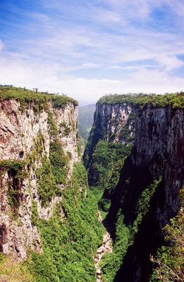
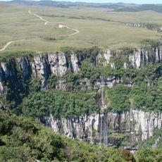
Itaimbezinho, Canyon in Cambara do Sul, Brazil
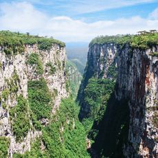
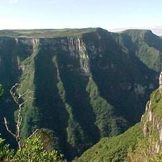
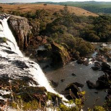
Itaimbezinho is a canyon with vertical rock walls that plunge about 720 meters deep, extending over a considerable length. Two main trails run along the upper edge and provide views of the towering cliffs and the landscape below.
The region was protected through the establishment of Aparados da Serra National Park, which safeguards the geological formations and natural ecosystems. This protection has helped preserve the canyon landscape over time.
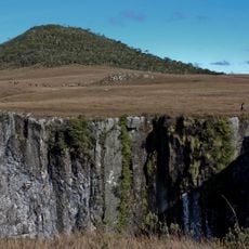
The name comes from the Tupi-Guarani language, meaning sharp stone, which reflects the steep rock walls visible throughout the site. Visitors can sense this linguistic connection to the landscape as they walk along the dramatic cliffs.
Marked trails allow visitors to explore the canyon, with one path about 1.4 kilometers long and suitable for most fitness levels. Bring adequate water and sun protection, as the exposed edges can be exposed to strong sun and wind.
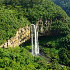
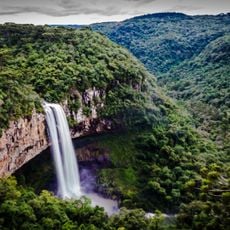
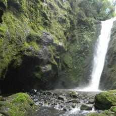
A waterfall called Cascade of the Swallows flows through a rock formation that serves as a nesting place for swallows. This combination of flowing water and rock creates a lively habitat within the canyon walls.
Location: Rio Grande do Sul
GPS coordinates: -29.17500,-50.09167
Latest update: December 6, 2025 16:04
The South Region of Brazil brings together nature reserves, waterfalls, beaches, and mountain peaks. Here you find geological formations such as canyons and caves, plus islands with archaeological sites. The landscape ranges from the Atlantic coast to inland highlands, where subtropical rainforest...
Cathedral of Our Lady of Lourdes
72.8 km
Aparados da Serra National Park
2 km
Mini Mundo
79.6 km
Caracol Falls
75.6 km
Serra Geral National Park
14.9 km
Caracol State Park
75.6 km
Pico do Monte Negro
68.1 km
Mundo a Vapor
75.1 km
Khadro Ling Buddhist Temple
72.2 km
Fortaleza Canyon
18.1 km
Praia da Guarita
40.2 km
Parque Estadual José Lutzenberger
40.2 km
Igreja Matriz de São Domingos
39.9 km
Tainhas State Park
28.5 km
São Francisco de Paula National Forest
39.7 km
Dreamland Gramado
76.4 km
Itapeva State Park
38.7 km
Igreja Gabriel
81.1 km
Araranguá Lighthouse
75.8 km
Morro de Osório Protected Area
81.7 km
Capão da Canoa Lighthouse
64 km
Mampituba North Mole Lighthouse
40.5 km
Mampituba South Mole Lighthouse
40.7 km
Torres Lighthouse
40 km
Fonte Imperial
82.6 km
Biblioteca Pública Municipal Júlio Costa
82.7 km
Torres Lighthouse
40 km
Museu da Via Férrea e Antropológico de Osório
81.2 kmVisited this place? Tap the stars to rate it and share your experience / photos with the community! Try now! You can cancel it anytime.
Discover hidden gems everywhere you go!
From secret cafés to breathtaking viewpoints, skip the crowded tourist spots and find places that match your style. Our app makes it easy with voice search, smart filtering, route optimization, and insider tips from travelers worldwide. Download now for the complete mobile experience.
A unique approach to discovering new places❞
— Le Figaro
All the places worth exploring❞
— France Info
A tailor-made excursion in just a few clicks❞
— 20 Minutes