Ngada, Administrative region in East Nusa Tenggara, Indonesia
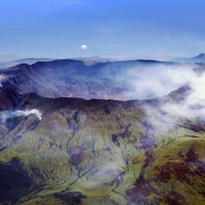
Ngada is an administrative region in East Nusa Tenggara comprising multiple districts with Bajawa as its capital at roughly 500 meters elevation. The region is characterized by hills dotted with traditional villages scattered across the landscape.
The region came under Dutch control when Captain Christoffel established presence in Bajawa in 1907, following Dutch takeover of Larantuka and Sikka areas. This colonial period shaped administrative structures that remain today.
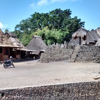
The communities here maintain traditions through distinctive houses with specific layouts that reflect ancestral values and social hierarchies. These structures shape the appearance of villages and show how local people preserve their identity today.
The region receives moderate rainfall from May to October and heavy rainfall from November to April, so visitors should pack accordingly depending on the season. The location is accessible via airports, and the elevation means the climate is cooler than in lower-lying coastal areas.
Roman Catholic practices blend naturally with local customs here, creating an unusual spiritual mix not seen in many other places. This merging of beliefs shows itself in daily rituals and how people celebrate festivals and interact with one another.
The community of curious travelers
AroundUs brings together thousands of curated places, local tips, and hidden gems, enriched daily by 60,000 contributors worldwide.