Chest opened
+${chestReward.xp} XP
Explorer
NOUVEAU ×${chestReward.collectible.quantity}
tapez pour fermer
Chest locked

Open chests in the app

Around Us is built for your phone — chests unlock when you walk, explore and capture nearby places.

Enable Location

We need your location to show you interesting places around you

Discover nearby places

Find interesting locations and hidden gems around you

Precise directions

Get accurate directions and distances to places

Your location is never shared with other users. It's only used when you tap the location button.

Providence Bay

Log in to your account

Start exploring — it's free

Trusted by 72,881 travelers worldwide

Continue with Google
Continue with Apple
or

We will send you a code to connect

By continuing, you accept our Terms and Conditions and our Privacy Policy

Check your inbox

We've sent a pincode in your inbox. Please enter the code below.

Providence Bay
Discussion Reviews 1 Photos
12.4k Popularity

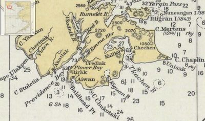
Providence Bay, Natural bay in Chukotka Autonomous Okrug, Russia.

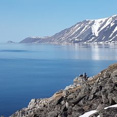
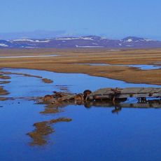
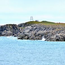
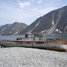
Providence Bay is a natural bay along the Chukotka Peninsula that extends about 34 kilometers inland from the coast. The shoreline features steep cliffs that rise 600 to 800 meters above sea level, giving the bay a dramatic landscape.

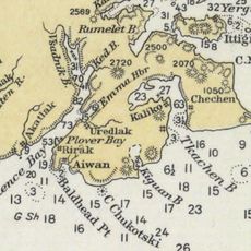
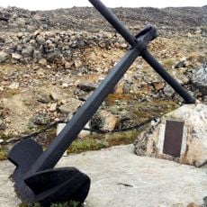
The bay gained historical importance when the British ship HMS Plover wintered at Emma Harbor in 1848-1849 while searching for the lost Franklin Expedition. This event marked the bay as a significant stop for Arctic explorers.

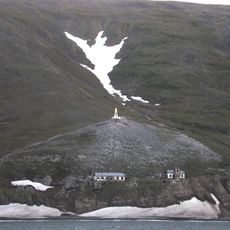
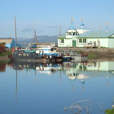
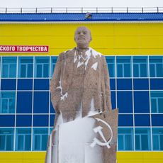
The bay serves as a center for local fishing and hunting traditions that shape daily life in the surrounding settlements. These practices remain visible in how residents use the waters and depend on the marine environment.

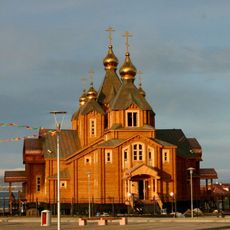
The bay remains ice-free from May to October, allowing access to port facilities at Emma Harbor and the settlement of Provideniya. Plan visits during these warmer months when navigation is possible.

The bay reaches depths of around 150 meters near its entrance, making it one of the deepest natural harbors along northeastern Asia's coast. This depth allowed large vessels to find shelter even in harsh conditions.

The community of curious travelers

AroundUs brings together thousands of curated places, local tips, and hidden gems, enriched daily by 60,000 contributors worldwide.

Start exploring
Part of
Bering Sea
GPS coordinates
64.41667,-173.40000
Latest update
December 7, 2025 20:45
Around this place
Naukan
Russian Federation

Naukan

247.8 km
Whale Bone Alley
Russian Federation

Whale Bone Alley

49 km
Beringia National Park
Russian Federation

Beringia National Park

7.4 km
Trinity Cathedral
Russian Federation

Trinity Cathedral

434.9 km
Monument to Semyon Dezhnev
Russian Federation

Monument to Semyon Dezhnev

247.9 km
Pilgrim Hot Springs
United States of America

Pilgrim Hot Springs

409.1 km
Cape Nome Mining District Discovery Sites
United States of America

Cape Nome Mining District Discovery Sites

385 km
Council City and Solomon River Railroad
United States of America

Council City and Solomon River Railroad

429.9 km
Old St. Joseph's Catholic Church
United States of America

Old St. Joseph's Catholic Church

383.5 km
Nome River
United States of America

Nome River

389.3 km
Snake River
United States of America

Snake River

380.4 km
Wales Site
United States of America

Wales Site

282.8 km
Cape Vankarem
Russian Federation

Cape Vankarem

397 km
Kougarok River
United States of America

Kougarok River

426.2 km
Kuzitrin River
United States of America

Kuzitrin River

437 km
Swanberg Dredge
United States of America

Swanberg Dredge

385.5 km
Solomon Roadhouse
United States of America

Solomon Roadhouse

429.5 km
Niukluk River
United States of America

Niukluk River

454.5 km
Shishmaref Inlet
United States of America

Shishmaref Inlet

404.8 km
Noxapaga River
United States of America

Noxapaga River

457.5 km
Slavyanka Cove
Russian Federation

Slavyanka Cove

6.1 km
Историко-культурный комплекс Пловер
Russian Federation

Историко-культурный комплекс Пловер

6.6 km
Памятный знак в честь 250-летия Первой Камчатской экспедиции (Провидения)
Russian Federation

Памятный знак в честь 250-летия Первой Камчатской экспедиции (Провидения)

7.3 km
Дворец Пионеров (Анадырь)
Russian Federation

Дворец Пионеров (Анадырь)

434.8 km
Историко-этнографический памятник «Коса Святого Александра» (Анадырь)
Russian Federation

Историко-этнографический памятник «Коса Святого Александра» (Анадырь)

434.4 km
Мемориальный комплекс «Памятник первым Ревкомовцам» (Анадырь)
Russian Federation

Мемориальный комплекс «Памятник первым Ревкомовцам» (Анадырь)

435.3 km
Памятник В. И. Ленину (Анадырь)
Russian Federation

Памятник В. И. Ленину (Анадырь)

434.8 km
Памятник «Авиаторам — первопроходцам и защитникам неба Чукотки» (Угольные Копи)
Russian Federation

Памятник «Авиаторам — первопроходцам и защитникам неба Чукотки» (Угольные Копи)

427 km
Show the full map
Reviews
Share your experience

No review yet

Discussions
Start a discussion...

No discussion yet

« Providence Bay - Natural bay in Chukotka Autonomous Okrug, Russia » is provided by Around Us (aroundus.com). Images and texts are derived from Wikimedia project under a Creative Commons license. You are allowed to copy, distribute, and modify copies of this page, under the conditions set by the license, as long as this note is clearly visible.

Discover hidden gems everywhere you go!

From secret cafés to breathtaking viewpoints, skip the crowded tourist spots and find places that match your style. Our app makes it easy with voice search, smart filtering, route optimization, and insider tips from travelers worldwide. Download now for the complete mobile experience.

Around Us App Screenshot

A unique approach to discovering new places

Le Figaro

All the places worth exploring

France Info

A tailor-made excursion in just a few clicks

20 Minutes

Around Us
Travel Guide & Maps
Download

Send to your phone

QR Code
1

Open the camera app on your mobile.

2

Point at the QR code with your camera. A notification will appear.

3

Tap the notification to open the link.