Nome River, Brook in Nome, Alaska
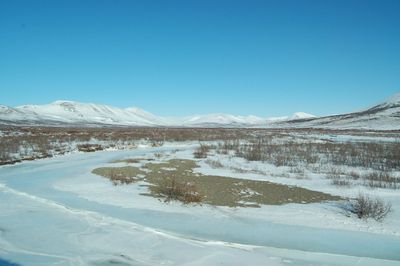
Nome River is a watercourse in Alaska that flows approximately 40 miles from the Kigluaik Mountains through a wide valley before reaching Norton Sound and the Bering Sea. Water depth varies significantly along its length, creating diverse habitats for fish and aquatic life.
The region became the center of a gold rush in the late 1800s when miners focused their operations primarily on the western side of the waterway. This period shaped the development and legacy of the surrounding area.
The river serves as a gathering place where local residents practice traditional fishing methods that have been part of their life for many years. People continue to rely on its waters for sustenance and daily routines.
The waterway can be accessed at multiple points along its course, and visitors should be prepared for changing weather conditions common to the region. Proper equipment and appropriate clothing are important for anyone spending time along or near the water.
Water depth shifts dramatically throughout the course, ranging from quite shallow to over 50 feet deep, which attracts different fish species and creates varied conditions for fishing. This variation allows the waterway to support diverse habitats within a relatively compact area.
The community of curious travelers
AroundUs brings together thousands of curated places, local tips, and hidden gems, enriched daily by 60,000 contributors worldwide.