Selawik River

Log in to your account

AroundUs is a community-driven map of interesting places, built by curious explorers like you. It grows with every review, story, and photo you share.
Connect to save your favorite spots, contribute locations, and create personalized routes.
Continue with Google
Continue with Apple
Continue with X
Continue with Facebook
Continue with email
By continuing, you accept our Terms and Conditions and our Privacy Policy
Create an account
Add to collection
Map
Suggest a change
Share

Selawik River, Brook in Purcell Mountains, US

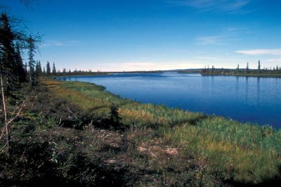
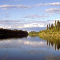
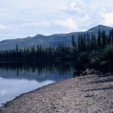
The Selawik River is a waterway in Alaska that flows westward through the Purcell Mountains and surrounding terrain toward Selawik Lake at sea level. It transitions from highland areas to tundra lowlands over its course.

This river was designated as a National Wild and Scenic River in 1980, formally recognizing its environmental importance. The designation protects its natural condition from commercial development.

The name Selawik comes from the Iñupiat language and means 'place of sheefish', showing how vital this waterway has been to local communities for fishing.

Visitors should use small motorized boats in the lower sections of the river, while upper areas require non-motorized watercraft only. Reaching the upper portions requires arriving by aircraft, as no road access exists.

The river undergoes a striking transformation along its course: in the highlands it runs clear over gravel, while in the lower tundra sections it becomes slow-moving and stained brown by tannins with a silty bottom. This change reflects the different geology and plant life encountered downstream.

GPS coordinates: 66.50156,-158.37710

Latest update: December 14, 2025 16:43

Photos
Around this place
Kobuk Valley National Park
United States of America

Kobuk Valley National Park

123.2 km
Gates of the Arctic Wilderness
United States of America

Gates of the Arctic Wilderness

289.1 km
Nowitna River
United States of America

Nowitna River

329.5 km
Mount Igikpak
United States of America

Mount Igikpak

179.9 km
Arrigetch Peaks
United States of America

Arrigetch Peaks

209.4 km
Trail Creek Caves
United States of America

Trail Creek Caves

240.2 km
Noatak Wilderness
United States of America

Noatak Wilderness

181.2 km
Kanuti National Wildlife Refuge
United States of America

Kanuti National Wildlife Refuge

291 km
John River
United States of America

John River

294.4 km
Koyukuk National Wildlife Refuge
United States of America

Koyukuk National Wildlife Refuge

132.8 km
Selawik National Wildlife Refuge
United States of America

Selawik National Wildlife Refuge

36.2 km
Nowitna National Wildlife Refuge
United States of America

Nowitna National Wildlife Refuge

286.7 km
Unalakleet River
United States of America

Unalakleet River

288.9 km
Chamisso Wilderness
United States of America

Chamisso Wilderness

156.9 km
Onion Portage Archeological District
United States of America

Onion Portage Archeological District

66.4 km
Kougarok River
United States of America

Kougarok River

308.5 km
Squirrel River
United States of America

Squirrel River

147.5 km
Kuzitrin River
United States of America

Kuzitrin River

303.6 km
Walker Lake
United States of America

Walker Lake

189.2 km
Kanuti River
United States of America

Kanuti River

306.4 km
Niukluk River
United States of America

Niukluk River

307.8 km
Iyatayet Site
United States of America

Iyatayet Site

274.3 km
Kugruk River
United States of America

Kugruk River

202.2 km
Shishmaref Inlet
United States of America

Shishmaref Inlet

335.8 km
Salmon River
United States of America

Salmon River

127.6 km
Noxapaga River
United States of America

Noxapaga River

276.3 km
Bureau of Indian Affairs Unalakleet School
United States of America

Bureau of Indian Affairs Unalakleet School

313.6 km
Kugururok River
United States of America

Kugururok River

239.5 km
Show the full map
Reviews

Visited this place? Tap the stars to rate it and share your experience / photos with the community! Try now! You can cancel it anytime.

« Selawik River - Brook in Purcell Mountains, US » is provided by Around Us (aroundus.com). Images and texts are derived from Wikimedia project under a Creative Commons license. You are allowed to copy, distribute, and modify copies of this page, under the conditions set by the license, as long as this note is clearly visible.

Discover hidden gems everywhere you go!

From secret cafés to breathtaking viewpoints, skip the crowded tourist spots and find places that match your style. Our app makes it easy with voice search, smart filtering, route optimization, and insider tips from travelers worldwide. Download now for the complete mobile experience.

Around Us App Screenshot

A unique approach to discovering new places

Le Figaro

All the places worth exploring

France Info

A tailor-made excursion in just a few clicks

20 Minutes