Enable Location

We need your location to show you interesting places around you

Discover nearby places

Find interesting locations and hidden gems around you

Precise directions

Get accurate directions and distances to places

Your location is never shared with other users. It's only used when you tap the location button.

Walker Lake

Log in to your account

Start exploring — it's free

Trusted by 62,297 travelers worldwide

Continue with Google
Continue with Apple
or

We will send you a code to connect

By continuing, you accept our Terms and Conditions and our Privacy Policy

Check your inbox

We've sent a pincode in your inbox. Please enter the code below.

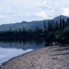
Walker Lake, lake in the United States of America

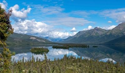
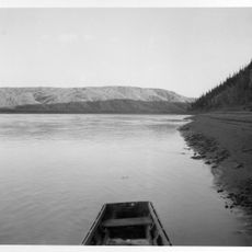
Walker Lake is a large glacially-formed body of water on the south slope of the Brooks Range in northwest Alaska. The lake stretches about 14 miles long and a mile wide on average, filling a basin carved by ancient ice and bounded by moraines of rock and soil.

The lake was explored in 1885 during an expedition led by John C. Cantwell, organized by the Revenue Marine, an early precursor to the Coast Guard. In 1968, it was designated a National Natural Landmark to recognize its natural significance and later incorporated into Gates of the Arctic National Park.

Local Inupiat people call the lake Qalugluktuaq, while the Denaakk'e language names it Taah K'ehoolaanh. Traditional stories describe legendary fish in the waters, with the indigenous name itself meaning Big Fish Lake, reflecting generations of connection to this place.

Access to the lake is typically by small airplane or on foot, as there are no roads to reach it. Visitors should bring adequate supplies and be prepared for rapidly changing weather, cold temperatures, and the remote wilderness conditions that define the area.

Local legend tells of a giant fish that a native hunter once tried to catch using a hook made from reindeer antlers and a whole goose as bait. This Inupiat tale reveals how the water held deep meaning and mystery for the people who have lived here for generations.

The community of curious travelers

AroundUs brings together thousands of curated places, local tips, and hidden gems, enriched daily by 60,000 contributors worldwide.

Start exploring
GPS coordinates
67.12670,-154.36300
Latest update
February 9, 2026 07:42
Around this place
Kobuk Valley National Park
United States of America

Kobuk Valley National Park

216.2 km
Mears Memorial Bridge
United States of America

Mears Memorial Bridge

372.7 km
E. L. Patton Yukon River Bridge
United States of America

E. L. Patton Yukon River Bridge

249 km
Gates of the Arctic Wilderness
United States of America

Gates of the Arctic Wilderness

121.5 km
Nowitna River
United States of America

Nowitna River

341.5 km
Yukon Flats National Wildlife Refuge
United States of America

Yukon Flats National Wildlife Refuge

377.9 km
Mount Igikpak
United States of America

Mount Igikpak

41 km
Arrigetch Peaks
United States of America

Arrigetch Peaks

33.6 km
White Mountains National Recreation Area
United States of America

White Mountains National Recreation Area

350.4 km
Noatak Wilderness
United States of America

Noatak Wilderness

243.6 km
Kanuti National Wildlife Refuge
United States of America

Kanuti National Wildlife Refuge

136.3 km
John River
United States of America

John River

105.3 km
Koyukuk National Wildlife Refuge
United States of America

Koyukuk National Wildlife Refuge

196.5 km
Selawik National Wildlife Refuge
United States of America

Selawik National Wildlife Refuge

218.7 km
Nowitna National Wildlife Refuge
United States of America

Nowitna National Wildlife Refuge

274.3 km
North Fork Koyukuk River
United States of America

North Fork Koyukuk River

155.5 km
Selawik River
United States of America

Selawik River

189.2 km
Chamisso Wilderness
United States of America

Chamisso Wilderness

343.6 km
Gallagher Flint Station Archeological Site
United States of America

Gallagher Flint Station Archeological Site

341.4 km
Onion Portage Archeological District
United States of America

Onion Portage Archeological District

170.4 km
Itkillik River
United States of America

Itkillik River

283.9 km
Squirrel River
United States of America

Squirrel River

291.4 km
Kanuti River
United States of America

Kanuti River

159.8 km
Rampart Canyon
United States of America

Rampart Canyon

248.7 km
Salmon River
United States of America

Salmon River

235.8 km
Dall River
United States of America

Dall River

236.7 km
Tolovana River
United States of America

Tolovana River

327.1 km
Kugururok River
United States of America

Kugururok River

323.7 km
Show the full map
« Walker Lake - lake in the United States of America » is provided by Around Us (aroundus.com). Images and texts are derived from Wikimedia project under a Creative Commons license. You are allowed to copy, distribute, and modify copies of this page, under the conditions set by the license, as long as this note is clearly visible.

Discover hidden gems everywhere you go!

From secret cafés to breathtaking viewpoints, skip the crowded tourist spots and find places that match your style. Our app makes it easy with voice search, smart filtering, route optimization, and insider tips from travelers worldwide. Download now for the complete mobile experience.

Around Us App Screenshot

A unique approach to discovering new places

Le Figaro

All the places worth exploring

France Info

A tailor-made excursion in just a few clicks

20 Minutes

Around Us
Travel Guide & Maps
Download

Send to your phone

QR Code
1

Open the camera app on your mobile.

2

Point at the QR code with your camera. A notification will appear.

3

Tap the notification to open the link.